
Cyclones have a range of severity right from being Tropical storms to intensifying into Super Cyclones. To understand the strength of these Cyclones, the factors that we look for include Wind Field, Eye Structure, and Cloud Top Temperature.
Wind Field: When the wind field around the centre of the storm becomes compact and organized, it shows a sign of strengthening. However, when the same becomes increasingly broad and asymmetric, it indicates the weakening of the storm.
Significant wind speed is anything in excess of 60 kmph. In a storm, there is a core of winds wrapped around the eye of the storm, which can cover an area of as much as 500 km as well.
Also, winds are not the same all over, it has an inner ring, and the outer ring. The wind speed varies as per the distance and the direction. There is a differential of winds in the storm, with respect to the eye, as far as directions and distance is concerned. For a significant Cyclone, the wind field should be compact and organized, which thereby indicates the strengthening of the storm.
Talking about the wind speed of storms in order of their organization.
Cyclonic Storm: 62 kmph - 88kmph
Severe Cyclonic Storm: 89 kmph – 117 kmph
Very Severe Cyclonic Storm: 118 kmph- 166 kmph
Extremely Severe Cyclonic Storm: 167 kmph – 221 kmph
Super Cyclone: in excess of 221 kmph
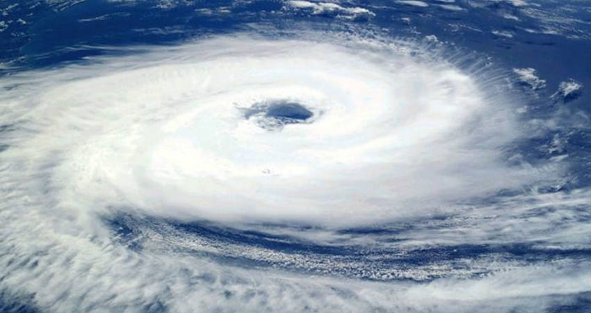
Eye Structure: The Cyclonic Storms in the beginning when they start getting organized, the cloud mass in the centre starts to take circular shape, which is called as Cloud Dense Overcast. Thereafter, because of the centrifugal force of strong winds around the centre of the storm, clouds get thrown away. Thus, the centre of the storm is free of clouds, and has calm winds, which is called the eye of the storm. Eye of the storm is also indicative of the strength of the storm
Every storm may not develop an eye, if it is a Cyclonic Storm, we generally do not see an eye. However, the eye develop after the system intensifies into a Severe Cyclonic Storm and onward. The Severe Cyclones have a ragged eye, Very Severe Cyclones have an oblong eye. Purely Circular eye is seen in Extremely Severe Cyclones and Super Cyclones.
Any sharpening and warming of the eye is indicative of the strengthening of the storm. Also, the eye extends right from the lower level, up to the height of the storm, which could be vertically around 30,000 feet and even beyond at times.
Cloud Top Temperature: Severe storms are associated with turbulent clouds around them extending up to Tropospheric levels.
The Tropical Cyclones do not always have uniform strength all around wherein some sides may be stronger than the other. The stronger the storm, the higher is its extent into the troposphere. There are small cells in the Cyclonic Storms have a relatively large vertical extent. The coldest cloud temperature is indicative of the strength of the storm.
These are the three most sort after parameters to identify the strength and the velocity of the storm.
Image Credit: wikipedia
Please Note: Any information picked from here must be attributed to skymetweather.com
