
 Ocean atmosphere interaction dictates quantum of rain distribution over various parts of the globe. Anomalous warming of central and east Pacific Ocean every 2-7 years results in episodes of El Niño. Out of them, few are followed by La Niña.
Oceans when heated up, retain the warmth for a duration of 6-12 months and the atmosphere keeps responding to these changes in the due course. These interactions generate weather cycles over different parts of the globe. Warming of Pacific Ocean results in trade wind reversal and accordingly, the thunderstorm activity shifts from the West Pacific to East and Central Pacific.
[yuzo_related]
Commencing 2010, this decade has seen extended episodes of cooling and warming in the Pacific. While the cooling phase from June 2010 lasted nearly for two years till May 2012, a warming phase caused one of the longest and strongest El Niño episode from Oct 2014 to May 2016. Also, the year 2016 saw unprecedented contrast phases with first half being warm and the second one becoming cold by equal margin. Oceanic Niño Index (ONI) witnessed a rapid swing from El Niño to La Niña conditions. The year 2017 also observed similar fluctuations but on somewhat smaller scale.

Between El Niño, Neutral and La Niña conditions there are no established linkages. There have been instances of La Niña following El Niño years like 1969-70, 1972-73, 1987-88 and 2009-10. Also, there are few cases on record that observed three consecutive La Niña years like 1973-74-75 and 1998-99-2000. On the other hand, El Niño has the longest history of lasting for 20 months from Oct 2014 to May 2016.
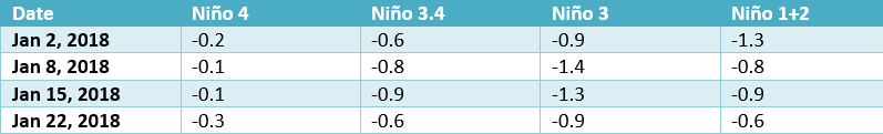
NOAA had issued La Niña watch earlier for the fall and winter of 2017-18 with chances of La Niña event at 55-60%. La Niña watch is issued when conditions are favorable for the development of La Niña with in the next six months. Presently the equatorial sea surface temperatures (SST’s) are below the average across central and eastern Pacific Ocean. La Niña is likely (85-95%) through Northern Hemisphere winters with a transition to ENSO – neutral expected during the spring. Niño indices in the Pacific for the last one month are as in the table.
January data of the Pacific Ocean starts providing initial indicators of health of Monsoon in the subsequent months. However, the credibility of data during February and March suffer due to ‘spring barrier’. More authentic and reliable information towards prediction of Monsoon rains emerge in April.
Just a gentle reminder to refresh our memories, may be at the cost of repetition, El Niño and La Niña bring both the good and bad news for different parts of the globe. While El Niño finds strong linkages with the poor Indian Monsoon rains, the La Niña event could end up ushering bountiful rains during the season.
Strong El Niño, in general, results in shadow of dampening rains for the Southeast Asia, including drought in some pockets. El Niño event also brings relief from the drought conditions over the far west in United State including California. This mischievous event reduces the number of hurricanes in the tropical Atlantic, Caribbean Sea and Gulf of Mexico. La Niña could bring more cheers than the grief around the globe.
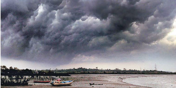
IMAGE CREDIT: Wikipedia
Any information taken from here should be credited to skymetweather.com
