
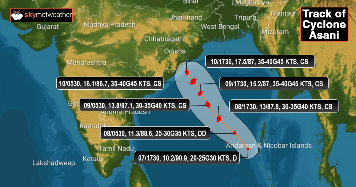
Updated on May 7, 2022, 05:30 PM: Well marked low pressure area over Andaman Sea has intensified to a depression. Weather system is centered around 9.6 degree North and 91.0 degree East, about 350 km westsouthwest of Port Blair.
It is likely to strengthen further to a deep depression tonight and a tropical storm by early tomorrow morning. The depression will move northwestward for nearly 48hr and move over central parts of Bay of Bengal, closer to the eastern shore.
Rough sea conditions with heavy to very heavy rains will be confined to the deep sea area, away from the chain of Bay Islands. Coastline of Andhra Pradesh will start experiencing outer peripherals of cloud bands later tomorrow.
Strong winds of the order of 50-60kmh and gusting to 70kmh are associated in the core area of the depression. System is to be watched for rapid intensification over the next 24hours.
Published on May 7, 2022, 12:30 PM: Low pressure area in the Bay of Bengal has deepened to become well marked. It is centered around 9.5 degree North and 91.5degree East. Associated cyclonic circulation has become increasingly well defined and compact. The convective cloud cluster is spread over South Andaman Sea over an area of 300 x 300 km. This area of convection has moved in the close proximity of chain of Bay Islands and also extended to cover parts of Southeast Bay of Bengal.
Invest area is now located in a favorable environment of low vertical wind shear and very warm sea surface temperature. Low pressure is likely to move northwestward and also intensify to a depression anytime soon. Potential for further intensification is very high and strengthening to a tropical storm is expected by early tomorrow. In the next 48-72 hours, it is likely to shift to West Central Bay of Bengal first and later over Northwest Bay, aligned with North Coastal Andhra Pradesh and South Odisha. Cyclone once established will be named as 'ASANI', as proposed by Sri Lanka.
Potential cyclone continue to throw a challenge for fixing its landfall position. Multiple variables of numerical model remain indecisive to pin point track and strike at this juncture. More clarity and precision likely to flow in the next about 36hr. Weather system remains under observation for predicting timings, track and intensity. Update at regular intervals will be shared by Skymet.
