
Severe Cyclonic Storm Gaja crossed Tamil Nadu Coast today early morning near Vedaranyam with a wind speed of about 100 kmph gusting up to 120 kmph. In fact, the storm defied the assumption and logic that it would weaken before crossing the coast.
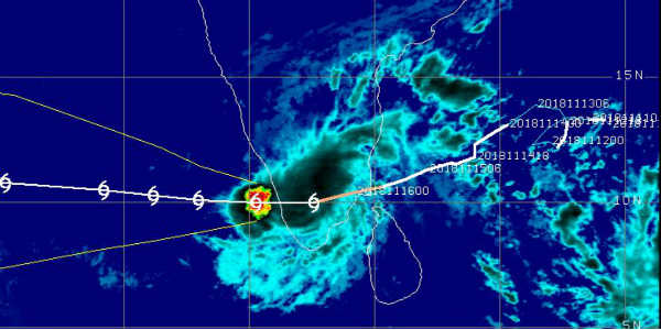
The cloud configuration this to be a very compact storm affecting mostly central parts and moving inland in west direction towards interior parts of Tamil Nadu.
In wake of this system, heavy to very heavy rains lashed the state of Tamil Nadu. In fact, since morning Cuddalore has recorded 87 mm of rain, followed by Puducherry 65 mm, Nagapattinam 64 mm, Parangipettai 62 mm, Kodaikanal 61 mm, Karaikal 54 mm, Pamban 47 mm and Thondi 34 mm.
Around 05:30 am today, the severe cyclonic storm weakened into a cyclonic storm and continued to move in west direction. Moreover, around 11:30 am today, Cyclonic Storm Gaja weakened into a deep-depression.
Further also this weakening trend is expected to continue and by today evening while heading towards Kerala across Tamil Nadu border, this system is expected to become depression.
The cloud configuration is clearly depicting its journey from cyclonic storm to depression moving through and through Tamil Nadu and entering Kerala. In fact, the peripherals of this storm in terms of inflow and outflow have also been clearly depicted.
The dense circular cloud mass has now degenerated to an amorphous bunch of clouds over parts of Tamil Nadu and Kerala.
Image Credits - cimss
Please Note: Any information picked from here must be attributed to skymetweather.com
