

As predicted by Skymet Weather, heavy with exceptionally heavy rains were observed by a few stations of Madhya Pradesh on the last day. Rains initiated from the southeastern parts of the state, after which Monsoon rains got activated over the south-western regions.
However, the southern portion of the state started witnessing rains after the arrival of July. On the past day, too rains were observed by most parts of the state. The intensity of these rains remained confined to the western half of the state, meanwhile, parts of East Madhya Pradesh received comparatively lesser rains.
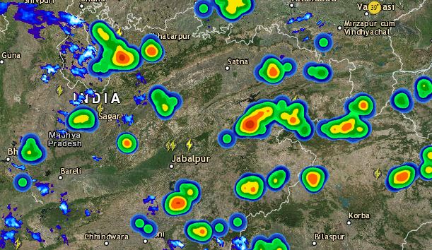
In the last 24 hours, from 08:30 am on Tuesday, Ujjain recorded extremely heavy three-digit rains to the tune of 110 mm, followed by Khandwa with 55 mm of rains, Datia 40 mm, Nowgong 38 mm, Ratlam 38 mm, Umaria 36 mm, Jabalpur 35 mm, Guna 32 mm, Sidhi 30 mm, Sagar 26 mm, Tikamgarh 18 mm, Khargone 11 mm, Sheopur 10 mm, Bhopal 5 mm and Indore recorded 2 mm of rains.
Click here to get the live lightning and thunderstorm status across Madhya Pradesh
As of now, the Axis of Monsoon trough is passing through North Madhya Pradesh, due to which, the rain belt has shifted towards north and north-western parts of the state.
Apart from this, a cyclonic circulation can also be marked over the southeastern parts of Madhya Pradesh. With the effect of these seasonal systems, there is a possibility of moderate to heavy rains in many areas of the state.
According to Skymet Weather, there are chances of heavy to very heavy rains over Jabalpur, Guna, Gwalior, Tikamgarh, Sagar, Damoh, Umaria, Rewa, Satna, Ratlam and Ujjain in the west and northwest parts of the state. This period of rain would continue for the next 2-3 days.
Moreover, the south and southeastern parts of the state, in cities like Khandwa, Indore, Bhopal, Betul, and Hoshangabad may also witness light to moderate rains. Isolated pockets of the state may also record some heavy showers.
According to weather experts, these weather systems are expected to remain active and thus Monsoon would continue to be effective for the next 2-3 days.
Due to the heavy rains, the temperatures would remain below normal in most cities of the state, giving extensive relief from the heat. However, there is a possibility of the swelling of the rivers and the water levels reaching above danger level, thereby alarming flood like condition.
Image Credit: Daily Bhaskar
Any information taken from here should be credited to skymetweather.com
