°C
Current temperature
5:30 AM, Jan 01, 1970Hourly
7 Days
15 Days

Weather buddy
Over the next 15 days, expect a series of thunderstorms followed by light rain. Temperatures will remain relatively high with an average ranging from 26.0°C to 30.0°C for most days in this forecast period; there is no significant rise in temperature expected after the initial few days, nor are we expecting a heatwave of 40°C or higher. In fact, temperatures do not reach highs that would indicate any severe heat waves exceeding 45°C daily maximum either. The highest recorded average will be on June 23rd at 30.9°C with some rainfall expected throughout the period, particularly towards the end of your stay starting from June 26th to July 1st. Prepare for thunder and light rain showers in these days as well.


Rainfall probability

Wind speed


Humidity
Sunrise/Sunset

Moonrise/Moonset


Weather buddy
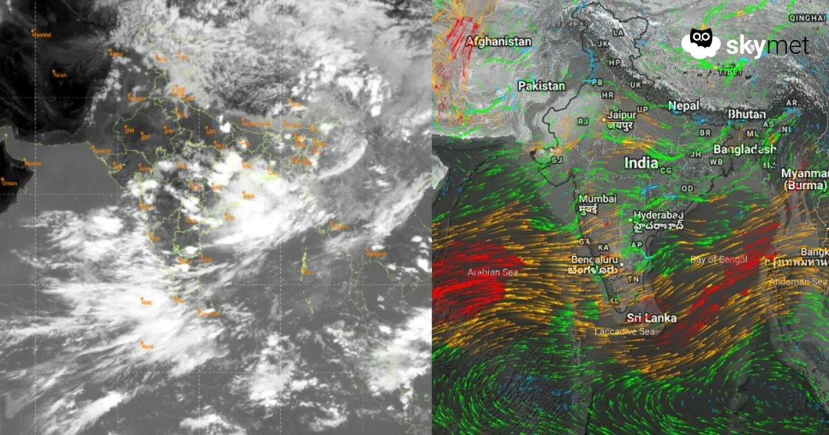
Today's weather will be marked by intense heat and significant thunderstorm activity. Morning temperatures are expected to range between 30°C to 35°C, with high humidity levels at 70%-88%. Early cloud cover remains minimal at only 5%, but this period is characterized by a thunderstorm that may impact outdoor plans. Moving into the evening, temperatures are forecasted to hover between 31°C and 35°C with slightly lower humidity levels of 69%-81%. Cloud cover will be minimal at around 4%, but rainfall is anticipated at about 3mm accompanied by strong winds reaching up to 29km/h, indicative of ongoing thunderstorm conditions. Nighttime temperatures are expected to drop slightly between 28°C and 30°C with high humidity levels rising from 86% to 92%. Cloud cover will remain low at around 4%, yet the presence of a night-time thunderstorm persists, although no precipitation is forecasted. It's advisable for residents to stay indoors during these times and keep an eye on weather updates.
 Temp (Min/Max)
THUNDER STORM Humidity
86%
 Dew Point
27°C
Highly Humid
 Wind speed
19 km/h
Wind Speed