

Delayed Arrival of Monsoon For Delhi Likely: Thunderstorm-Dust Storm Till Weekend


Key Takeaways:
- Southwest monsoon is likely to miss its normal onset date of June 27 over Delhi this year.
- The monsoon flow has stalled over Konkan and Muzaffarpur, slowing further advancement.
- Delhi will continue to witness light pre-monsoon showers and thunderstorms this week.
- Temperatures are expected to remain below 40°C with highs staying in the upper 30s till Sunday.
Advertisement
The normal date of southwest monsoon onset over Delhi is 27th June. Earlier, the onset date used to be 29th June and was revised in 2020. The monsoon has been arriving within ±5 days of its normal date for the last four years. However, there was an exception in 2021, when the monsoon reached Delhi on 13th July. This was the second most delayed onset over the national capital. The most delayed onset remains 1987, an El Niño year, when the monsoon arrived on 26th July, almost a month late.
Advertisement
Last year, the monsoon arrived over Delhi on 29th June along with the remaining parts of the country, completing coverage of the entire nation nearly a week ahead of the scheduled date of 8th July.
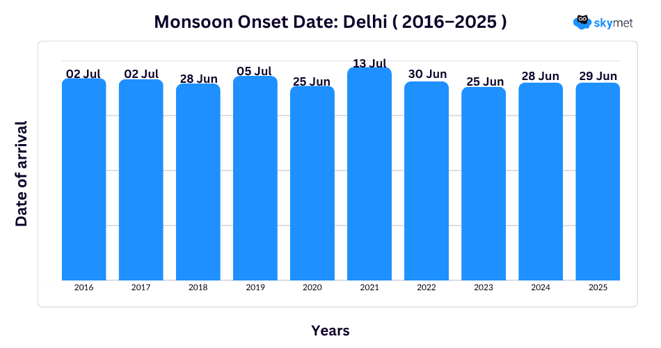
Monsoon is unlikely to arrive on or before the due date this season. The western end of the monsoon has stalled over the Konkan region. The eastern end, driven by the Bay of Bengal branch, has remained stationary near Muzaffarpur in Bihar for the last five days. No major advancement is likely on either end of the Northern Limit of Monsoon (NLM) for the next five days. Even after that, the progress is expected to remain slow and sluggish. Therefore, the arrival of monsoon over Delhi is likely to be delayed beyond the scheduled date of 27th June.
Despite the delayed onset, pre-monsoon activity will continue during the week. Rain and thunderstorm activity will remain short-lived and light in intensity. These weather systems will keep temperatures under check, and the mercury is unlikely to touch the 40°C mark.
Delhi recorded light to moderate showers yesterday morning. Palam and Safdarjung observatories registered 9 mm and 3 mm rainfall respectively, while Najafgarh recorded the highest rainfall of 24 mm. The base station Safdarjung recorded a maximum temperature of just 33.3°C yesterday, nearly 6°C below normal and the lowest daytime temperature recorded so far this month. Even the minimum temperature remained around 4°C below normal. A marginal rise in temperatures is expected over the next 3–4 days, with the mercury likely to stay in the higher 30s till Sunday.
Trending:



