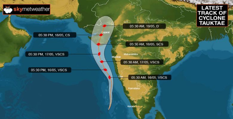
Updated on May 17 6:00 PM:Cyclone Tauktae landfall starts, extremely heavy rains and strong winds lash the Gujarat and Diu coast
Extremely Severe Cyclone Storm Tauktae landfall process started around 8.30pm and is likely to go on till 11pm. The eye of the cyclone could be seen with 40km diameter just short of the coast, though becoming ragged. The cyclone is making landfall east of Diu by about 35km in the Bhavnagar district.
The landfall process gets complete when the rear portion of the inner ring os storm crosses over to land which is likely by 11pm.
Extremely heavy rainfall accompanied with gale speed winds are expected over Diu, Amreli, Bhavnagar, Mahuva, Gir Somnath, Veraval and Junagadh. Next 6 hrs, heavy rainfall belt will cover Rajkot, Morbi, Ahmedabad, Anand, Gandhinagar and further on to North Gujarat.
Updated on May 17 6:00 PM:Cyclone Tauktae intensified to become an extremely severe cyclonic storm
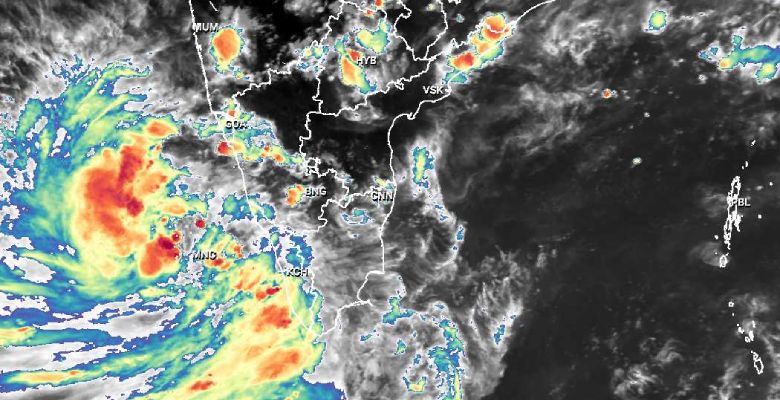
Cyclone Tauktae has further intensified to an Extremely Severe Cyclonic Storm with wind speed going up to 200kmh in the inner ring. The storm is centered around 19 Degree North and 73.1 Degree East and has moved northwest in the past 6 hours with a speed of about 16kmh. Cyclone Tauktae is abeam Mumbai about 120km away over the East Central Arabian Sea and a little over 200km from Veraval. The cyclonic storm will move more of northward heading for the Gujarat coast.
The cyclone is an extremely severe system, equivalent to Cat-IV hurricane, just one stop short of the topmost category Super Cyclone. It is still intensifying and increasing its wind potential.
The storm continues to have an eye of about 25km in diameter which is well defined but is likely to become ragged in the next 6 hours.
The storm continues to be in favorable environmental conditions with low vertical wind shear and high Sea Surface Temperature (31 degrees). The storms also remain compact with cloud bands wrapped tightly around the center.
The cyclone will be heading a little rapidly towards the Saurashtra coast and possible landfall in the late evening or early night today (1900 - 2200 hr), between Diu and Bhavnagar, somewhere close to Jafarabad in Amreli district. Extremely strong winds in excess of 150kmh and touching 180kmh are expected along with torrential rains over Mahuva, Bhavnagar, Amreli, Diu, Junagarh, Gir Somnath, and Porbandar districts.
Updated on May 17 9:00 AM:Cyclone Tauktae intensified to become an extremely severe cyclonic storm
Updated on May 16 9:00 PM:Cyclone Tauktae intensified to become severe cyclonic storm
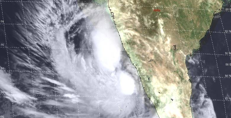
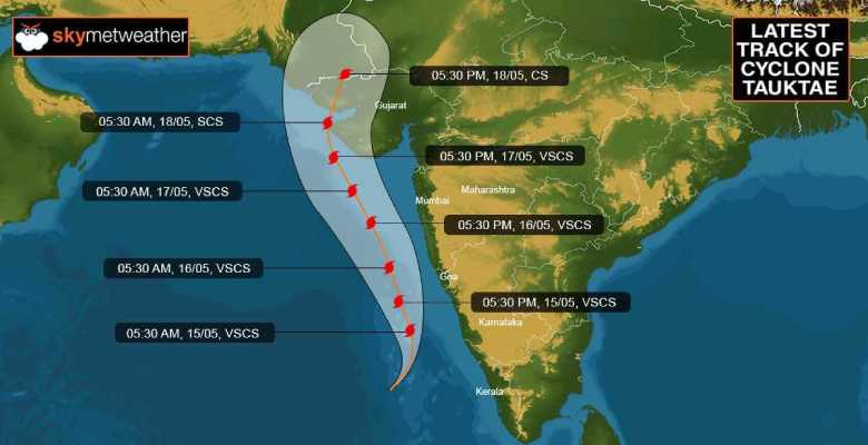
Cyclone Tauktae in the East Central Arabian Sea has intensified further to a Very Severe Cyclonic Storm and is centered around 15.3 Degree North and 72.7 Degree East. The storm has moved North- Northwest in the past 6hr with a speed of about 10kmh. It is positioned 100km abeam Goa to its west in the Arabian Sea and at a distance of about 420km south of Mumbai. The cyclone is closest to the coast now and will gradually increase its distance from the coast while moving North- Northwest.
The satellite imagery depicts that the cyclone has a circular dense overcast (CDO) cloud mass with a pinhole eye seen in the high-resolution pictures. The cloud configuration has become more compact and the feeder bands have become tighter, a display of its intensification.
Tauktae remains in an excellent environment, well suited for further intensification. The winds in the inner ring are of the order of 120-130kmh and by evening will pick up to reach about 160kmh. The storm continues to have poleward outflow, low vertical wind shear, and very warm sea surface temperature (31 degrees celsius). The wave height is expected to be in excess of 25feet.
Extremely heavy rains with high-velocity gale speed winds are expected along and off Coastal Karnataka( Karwar, Mangalore, Shirali, Gokarna, Honnavar), Goa-Panjim, and South Konkan including Ratnagiri. Moderate rains will lash North Kankan including Mumbai, Thane, Alibag, and Sindhudurg.
The cylone Tauktae is heading for Gujarat and is likely to make landfall near Vanabara (Diu) on the 18th morning as a very severe cyclonic storm. The complete coastline from Mahuva to Porbandar remains vulnerable and Junagarh, Amreli, Bhavnagar, Veraval, Porbandar and Diu will face the storm fury. Utmost caution needed for the entire Saurashtra to safeguard life and assets.
Updated on May 15 9:00 PM:Cyclone Tauktae intensified to become severe cyclonic storm
Cyclone Tauktae has further intensified in to a Severe Cyclonic Storm centered around 13.5Degree North and 73.3Degree East, about 220 km southwest of Goa. The storm is almost abeam Mangalore and nearly moved northward in the past 3 hours. It is likely to move further North-Northwest thereby gradually increasing its distance from the coastline.
Tauktae continue to enjoy favorable environmental conditions of having moderate vertical wind shear, very warm sea surface temperature and radial outflow. It is likely to intensify further in to a very severe cyclonic storm and head for extreme western parts of Saurashtra. As of now, the storm is expected to reach Gujarat coast on the 18th May and likely to cross close to Porbandar.
Heavy to very heavy rains with squally winds are expected over Kerala, Coastal Karnataka and South Konkan in the next 24hr. Mangalore, Karwar and Shirali in coastal Karnataka are likely to experience extremely heavy rains with gusty winds in the next 24 hours.
Updated on May 15 3:00 PM:Cyclone Tauktae to become a severe cyclonic storm shortly
Cyclone Tauktae has nearly tracked northward with a speed of about 8kmh in the past 6 hours. The storm is centered around 12.5degree north and 72.5degree east, about 350km South-Southwest of Goa, and 950km South-Southeast of Veraval. Due to excellent environmental conditions, Tauktae is likely to become a Severe Cyclone anytime soon and further Very Severe Cyclonic Storm in the subsequent 36hr. The winds are expected to pick to about 150-160kmh around that time in the inner circle of the storm.
Updated on May 15 7:00 AM:Cyclone over the Arabian Sea to intensify further into severe cyclonic storm shortly
Cyclone Tauktae has tracked North-Northeast slowly with a speed of less than 10kmh in the past 6 hour. The storm will move shortly towards north and later recurve towards North-Northwest. There is a bit of divergence among various models about the timings of recurvature. Actually, after moving over open waters of the Central Arabian Sea for about 48-72hr and intensifying to Very Severe Cyclonic Storm, there is the possibility of slight change in the track again before it finally heads for western parts of Saurashtra.
Environmental conditions continue to be favorable in terms of weak vertical wind shear and very warm sea surface temperature (SST). The SST is dropping a bit close to the coastal belt of the Sind (Pakistan) and Gujarat coast. A fresh call will be taken to comment on these aspects at an appropriate time. Hazardous weather conditions need to be tackled effectively over the next 48 hours over Kerala, Karnataka, and Konkan.
Updated on May 14 6:30 PM:Cyclone forms over the Arabian Sea, to intensify further into severe cyclonic storm shortly
Depression in the Arabian Sea has intensified into a cyclonic storm Tauktae and as per JTWC (Joint Typhoon Warning Center- Pearl Harbour) is centered around 11.9degree North and 72.3degree East over East Central Arabian Sea, about 200km Southeast of Mangalore. The storm has moved North-Northeast in the past 6 hours and is likely to move now more of Northward and later North-Northwest and also intensify into Severe Cyclonic Storm in the next 24 hours. Later in the subsequent 36hr, it will further intensify into a Very Severe Cyclonic Storm.
The satellite imagery depicts the storm as a rapidly consolidating system with deep convective banding and strong poleward outflow. The storm continues to be in favorable environmental conditions with very warm Sea Surface Temperatures and weak vertical wind shear. It is likely to attain strength equivalent to Cat-III hurricane while over open waters of the Central Arabian Sea.
Initial indications suggest that the cyclone is heading for extreme western parts of Saurashtra (Gujarat) and the coastline from Veraval to Dwarka will come under its strike range. Storms are known for changing track and timelines along with intensity. Skymet will keep a close watch and apprise accordingly.
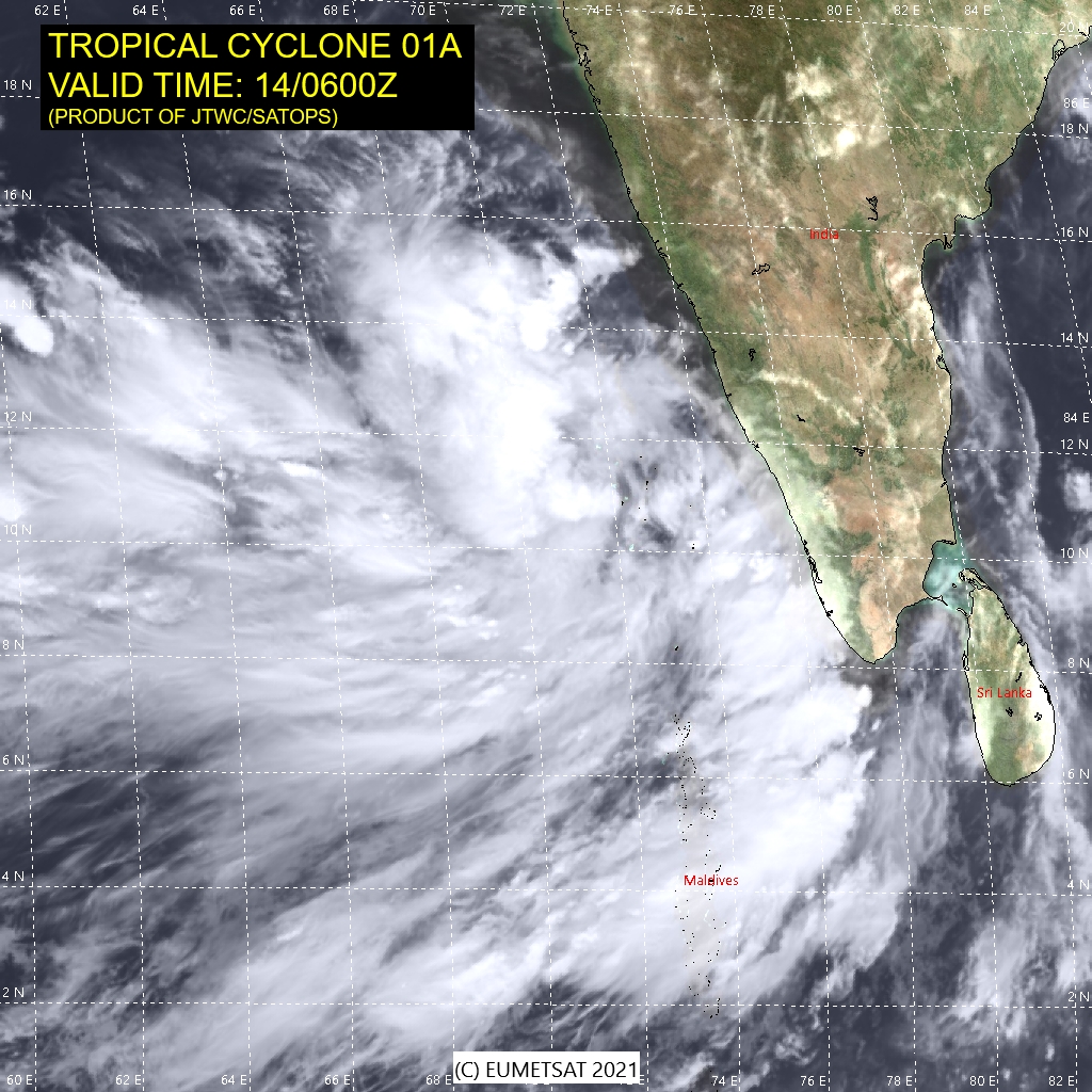
Updated on May 14 3:30 PM:Tauktae just one grade lower than cyclone, depression forms over Lakshadweep sea
Yesterday's low-pressure area over the Lakshadweep region became well marked in the late night and has further intensified now to a depression. The weather system has moved East-Northeast and is now centered around 10.9 Degree North and 72.4Degree East over Lakshadweep Sea with a wind speed of about 55kmh. The depression is likely to intensify rapidly to a cyclone and move initially northward.
Current satellite imagery depicts a broad area of deep convective clouds with formation banding as a sign of intensification. The weather system is positioned in favorable environmental conditions with strong radial outflow, low vertical wind shear, and very warm sea surface temperature 30-31degree celsius. Numerical models are in agreement that quick consolidation and intensification are expected as it moves northward in the next 24-48hr. Accordingly, the potential for the development of a significant cyclone in the next 24 hours is high.
Cyclone Tauktae is not likely to cross West Coast anywhere along its route and nearly move parallel to the coast till abeam Goa. Thereafter its distance from the coast may gradually increase while heading for Gujarat. More clarity on the timelines with precision needs another 36 hours.
Heavy to very heavy rains with squally winds are likely over the complete chain of islands in the Lakshadweep Sea. Agathi has already received 369mm of rainfall in the last 72hr and it is still pouring. Extremely heavy rains with gusty winds are expected over Kerala and Coastal Karnataka in the next 24hr and prolong further with the shift of the system along the coast. Three-digit rainfall of 100mm or in excess is predicted for the coastal belt. The astronomical tide may further raise the storm surge inundating many areas. Hazardous conditions are expected over Kerala and Coastal Karnataka to start with for the next 48hr. Exercise caution and adopt safety measures to secure life and assets.


