Cyclonic Strom 'Ditwah' Near Sri Lanka: Likely Move Towards Tamil Nadu

Key Takeaways
- Cyclone Ditwah has formed near the southeastern coast of Sri Lanka and is expected to move toward Tamil Nadu between 28–30 November.
- The system may not become very severe due to weak Coriolis force and land proximity but will sustain for at least 48 hours.
- Heavy to very heavy rainfall is expected across coastal and interior Tamil Nadu, with impact extending into Andhra Pradesh and Kerala.
- Potential hazards include flash floods, landslides, strong winds, transport disruptions, and possible dual landfalls over Sri Lanka and Tamil Nadu.
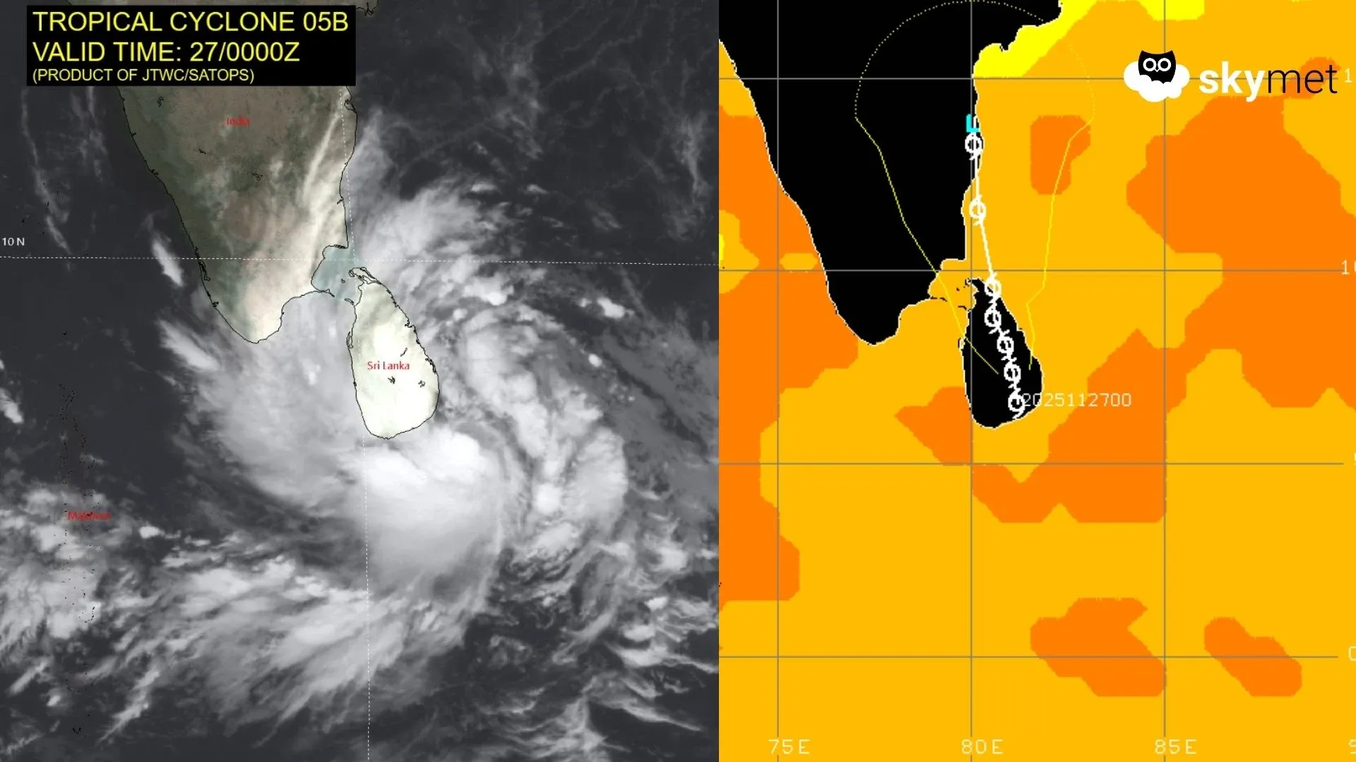
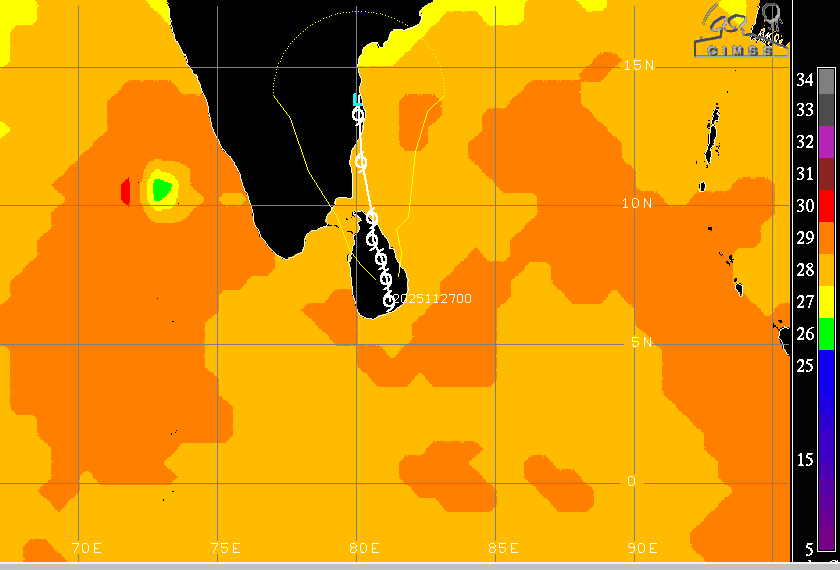
Under the influence of a strong cyclonic circulation associated with a deep depression, another cyclonic storm has formed over the equatorial region, very close to the extreme southeastern coastline of Sri Lanka. The coastline closest to the storm lies near Galle, Weligama, Matara, Tangalla, and Hambantota. The cyclone is centered around 6.3°N and 82°E. The Joint Typhoon Warning Center (JTWC) at Pearl Harbor announced the formation of the cyclonic storm in the early hours of 27 November 2025. The storm will be named ‘Ditwah,’ as advised by the member country Yemen. Unlike the previous storm ‘Senyar,’ which spared mainland India, Ditwah is expected to lash the coastline of Tamil Nadu, particularly over the weekend between 28 and 30 November 2025.
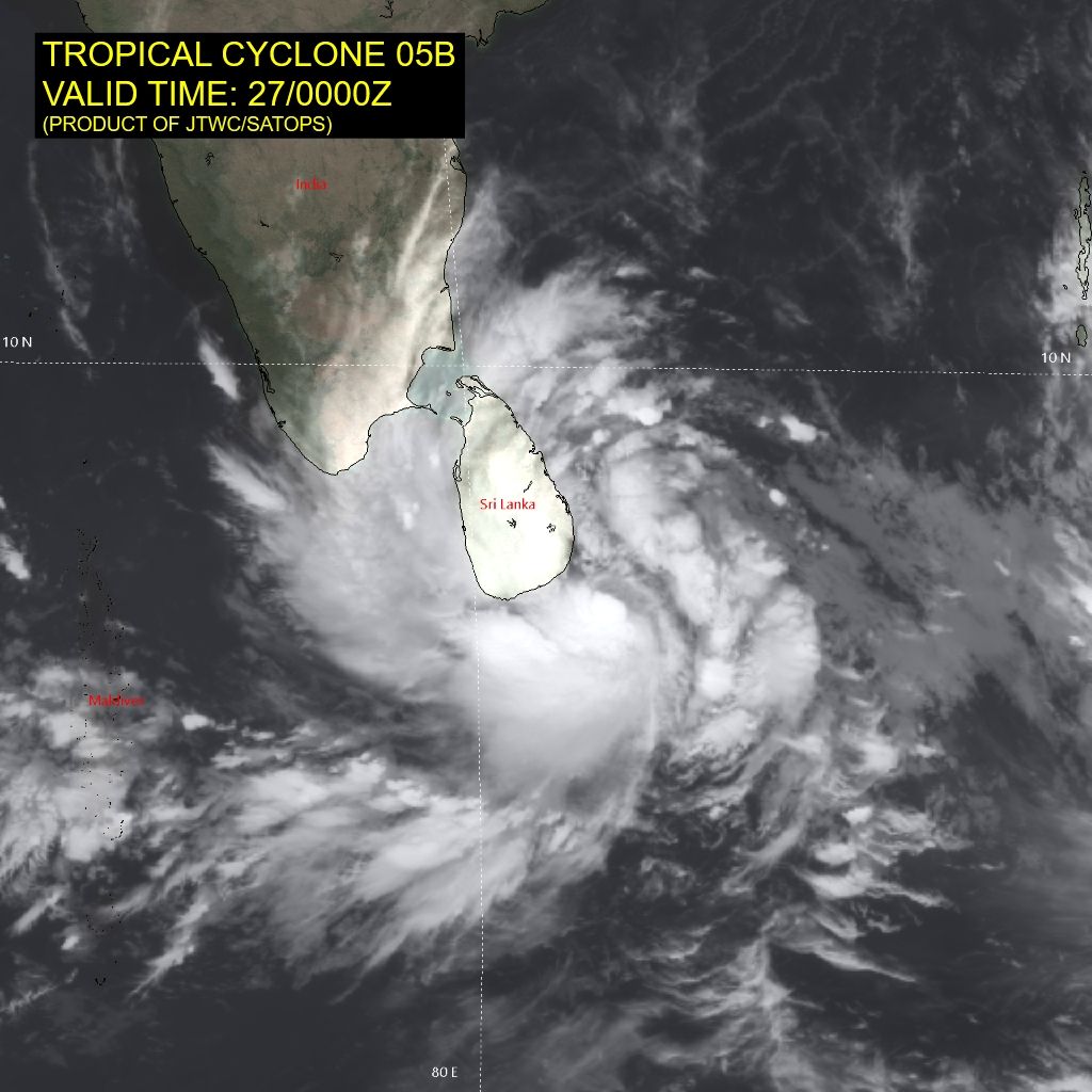
The cyclone is positioned quite low in latitude and will not generate a large amount of Coriolis force, and therefore may not become very severe. Although the storm is placed in marginal environmental conditions with low to moderate vertical wind shear, warm sea surface temperatures still favour its intensification. Countering this will be its proximity to land, causing friction and entrainment of dry air. Overall, the storm is expected to sustain itself for at least the next 48 hours. The cyclone is likely to move north-northwestward and northward, remaining in close proximity to Sri Lanka, the Gulf of Mannar, the Palk Strait, and Tamil Nadu.
Peripheral clouds of the storm have already reached the southeastern coastline of Tamil Nadu and will advance further with the system's northward movement. The locations at risk of very heavy rainfall include Nagercoil, Kanyakumari, Tuticorin, Pamban, Tondi, and Thoothukudi. Rainfall will then travel up the coastline from Nagapattinam to Chennai, including Puducherry, Karaikal, and Cuddalore. Even interior regions of the state—such as Madurai, Tiruchi, Thanjavur, Erode, Karur, Salem, Coimbatore, Tiruppur, and Ooty—will receive heavy rainfall accompanied by strong winds. Heavy rain will also reach coastal Andhra Pradesh, Rayalaseema, and interior parts of Kerala.
Cyclone Ditwah may have the distinction of making two landfalls: one over Sri Lanka and another over Tamil Nadu. Since model forecasts degrade after about four days, the system will be tracked closely and updates will be shared accordingly. Nevertheless, the state of Tamil Nadu needs to prepare with all available resources to face the storm’s impact. Inclement weather events such as flash flooding, landslides, uprooting of trees, transmission line outages, and disruption of surface travel are very likely. Rail, road, and air traffic are expected to be affected, disturbing normal life.