NISAR Satellite Launch on July 30: All You Need to Know About the NASA-ISRO Earth Mission


NASA-ISRO’s NISAR Satellite Set to Launch on July 30: A New Era in Earth Observation
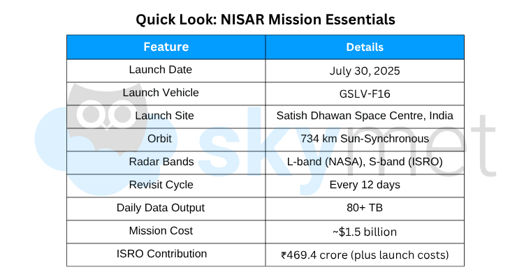
The global Earth observation community is abuzz as NASA and ISRO prepare to launch NISAR (NASA-ISRO Synthetic Aperture Radar) on July 30, 2025, at 5:40 PM IST from Satish Dhawan Space Centre, Sriharikota. This mission marks a monumental milestone — the first-ever collaboration of this scale between the Indian and U.S. space agenThe Indian Space Research Organisation (ISRO) and the National Aeronautics and Space Administration (NASA) are all set to launch NISAR — NASA-ISRO Synthetic Aperture Radar — on July 30, 2025, at 5:40 PM IST. The satellite will be launched aboard ISRO’s GSLV-F16 rocket from the Satish Dhawan Space Centre, Sriharikota.
What is NISAR?
NISAR is an Earth observation satellite jointly developed by NASA and ISRO. It will be the first satellite in the world to operate with two radar frequencies simultaneously — L-band (by NASA) and S-band (by ISRO). This enables it to capture high-resolution, all-weather, day-and-night images of Earth’s surface, providing unprecedented insights into natural and human-induced changes.
Key Highlights of the Mission
1. First-of-its-Kind Dual Radar Technology
NISAR will use both L-band and S-band synthetic aperture radars to track changes on Earth's surface — from glacial retreat and tectonic movement to soil moisture and crop conditions.
2. Frequent Global Scans
The satellite will scan almost the entire globe every 12 days, making it possible to monitor ecosystems, agricultural zones, forests, wetlands, and urban infrastructure more frequently and accurately than ever before.
3. High-Resolution, All-Weather Imaging
NISAR can detect changes as small as 1 cm, even in cloudy conditions or low light, making it extremely useful for disaster monitoring, climate studies, and infrastructure risk assessment.
Applications and Benefits
Disaster Management: Helps detect ground movements linked to earthquakes, landslides, volcanoes, and structural weaknesses in dams or levees.
Agriculture & Water Monitoring: Tracks soil moisture, crop health, and surface water levels, aiding smarter farming and irrigation decisions.
Climate Change Tracking: Monitors melting glaciers, sea ice, forest loss, and permafrost degradation, contributing valuable data for climate models.
Infrastructure Monitoring: Useful for observing subsidence near roads, bridges, and urban developments.
Mission Development and Collaboration
The project represents a major milestone in U.S.-India space cooperation:
The L-band radar, communication system, and reflector antenna were developed by NASA’s Jet Propulsion Laboratory (JPL) in California.
The S-band radar, launch vehicle, satellite bus, and mission operations are provided by ISRO, with hardware contributions from Space Applications Centre, U R Rao Satellite Centre, Vikram Sarabhai Space Centre, and NRSC.
NISAR is the culmination of over a decade of technical collaboration between NASA and ISRO, and builds on past successes like Chandrayaan-1, RISAT, and the Axiom Mission 4.
Data Accessibility
NISAR will generate over 80 terabytes of data per day, which will be freely accessible to users worldwide. The mission aims to support decision-making in sectors like:
- Disaster preparedness
- Agriculture
- Water resource management
- Ecosystem protection
- Climate resilience
Final Preparations
As of July 18, NISAR has been encapsulated in its payload fairing, which protects it during launch. Once in orbit, the satellite will be deployed into a 734 km sun-synchronous orbit, allowing consistent observations over the same locations at the same local time each day.
Conclusion
With the successful launch of NISAR, India and the United States are taking a historic step forward in Earth science, technology sharing, and climate resilience. NISAR promises to deliver cutting-edge data that will reshape how scientists, governments, and communities understand and respond to the changing planet.
Photo Courtesy: nasa.gov