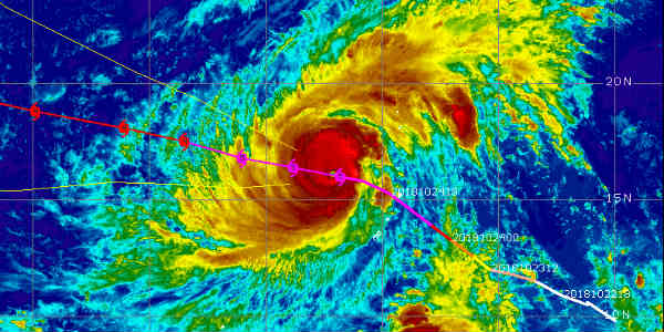
After becoming the strongest typhoon on record, the Super Typhoon Yutu is presently moving far from the Northern Mariana Islands in the Western Pacific Ocean over the US island territories of Saipan and Tinian.
[yuzo_related]
Yutu will hit the Northern Philippines, Taiwan and the Ryukyu Islands of Japan by next week. However, it is still too early to know if Yutu would strike any of these locations or it would recurve northeastwards towards the sea.
The storm rapidly intensified from a Category 1 to Category 5 super typhoon in the 24 hours ending 4 PM Wednesday local time. The maximum wind speed around the eye of the storm remains at 280 kmph.
Typhoon warnings remain in effect for the islands of Saipan, Tinian and Rota, and a tropical storm warning continues for the far northern islands of Alamagan, Pagan and Agrihan.
Yutu will weaken gradually as it moves west-northwestward into the Philippine Sea, however would remain a strong Category 3 or 4 typhoons through Monday.
Gusty winds will lash Saipan, Tinian and Rota through late Thursday morning as per local time. A storm surge of 5 or more feet is expected, however it would gradually subside through Thursday. High surf and rip currents are expected over the Marianas on Thursday evening.
About 50 to 130 mm of rainfall is expected triggering flash floods and landslides in the higher terrains. A flash flood warning has been issued for the islands.
Yutu indeed is a dangerous and deadly storm. The Pacific is known for producing some of the most intense storms on Earth and this one is still superlative.
Image Credit: CIMSS