

El Nino Transition To 'Strong' Category In August Likely


Key Takeaways:
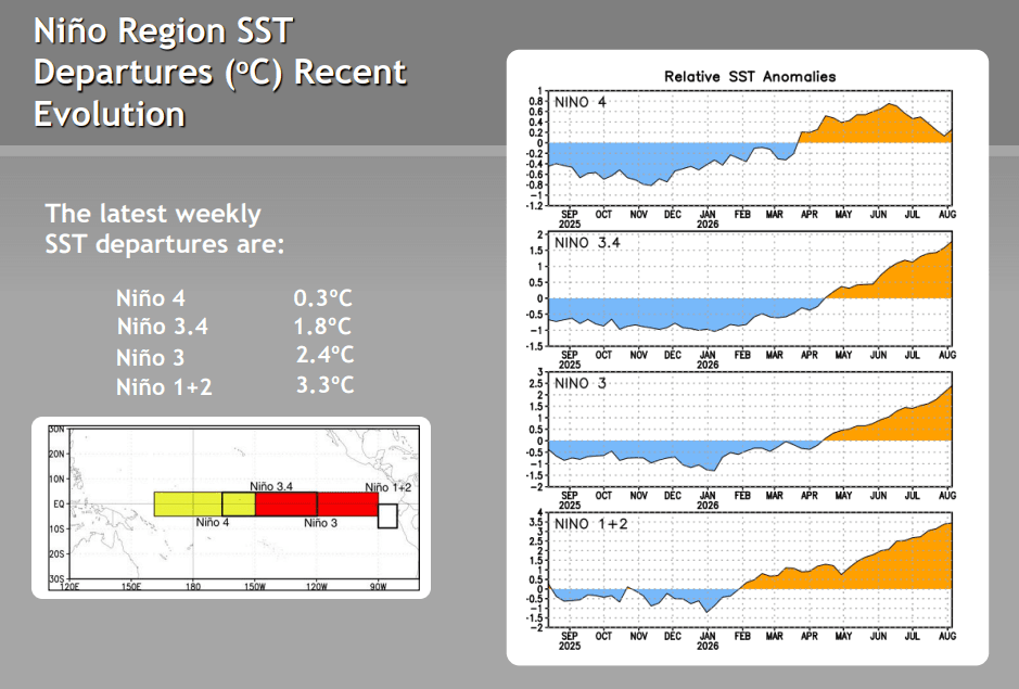
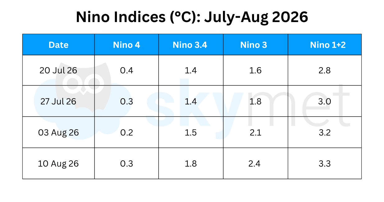
- Nino 1+2 has warmed sharply from 1.7°C to 3.3°C since June 2026, while Nino 3 has breached the 2°C mark.
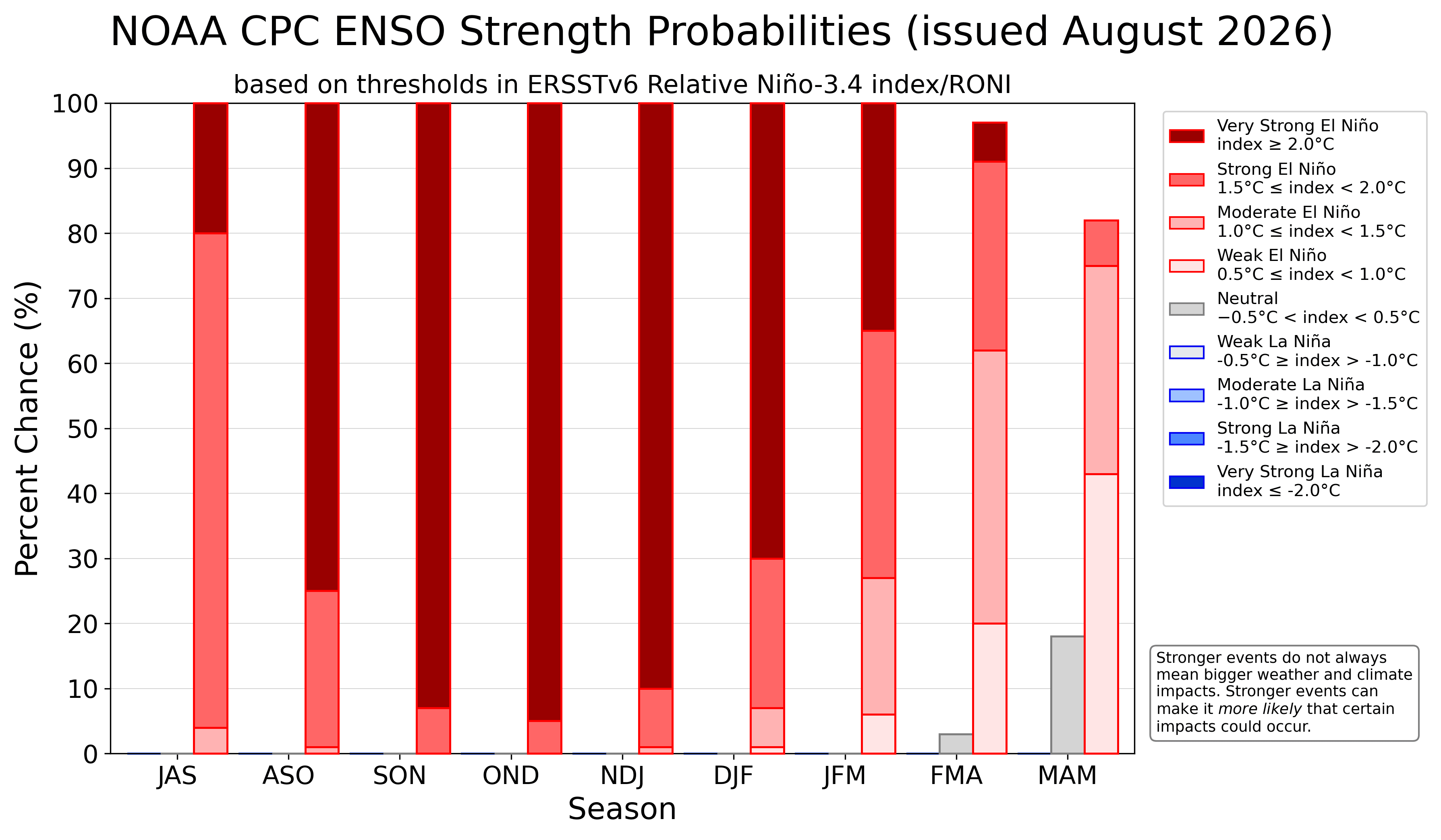
- Nino 3.4 is transitioning from moderate towards strong El Nino conditions, with oceanic and atmospheric indicators increasingly aligned.
- The IOD remains neutral, although its index has reached the positive IOD threshold for three consecutive weeks.
- El Nino is expected to peak after October 2026, raising the risk of weaker rainfall during the terminal Sep-Oct phase of the Indian monsoon.
- Until Next El Nino Update.
Advertisement
Since mid-April, above-average equatorial sea surface temperatures have increased across the east-central and eastern Pacific Ocean. Since Jan 2026, SST anomalies have decreased near the Date Line. Since June 2026, the Nino 1+2 region has warmed from 1.7°C to 3.3°C. Nino 3 has also breached the 2°C mark. Nino 3.4 is transitioning from moderate to the threshold of strong El Nino. Amidst all this warming, Nino 4, on the extreme western flank of the Nino region, has dropped from 0.8°C to 0.3°C.
Advertisement
As per BoM, the Relative Nino 3.4 index crossed the temperature anomaly of 2°C for the second consecutive week. The latest value, as of 09th Aug 2026, was 2.2°C. For comparison, the two strongest El Nino events on record, 1997 and 2015, did not reach that level until October. This exceptionally rapid warming during the summer is a strong signal that El Nino could become one of, if not the strongest, on record by the fall of the year and winter 2027.
In the long range, this will have major implications for global weather patterns, including storms in the Pacific and Atlantic, precipitation over the Indian subcontinent, winter conditions over North America, and modification and undulation of the Westerly Jet Stream.
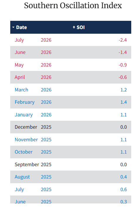
ENSO: Both the oceanic and atmospheric indicators are adequately aligned and consistent with a strong El Nino. The Southern Oscillation Index, the sea level pressure difference between Tahiti and Darwin, has become strongly negative. The average SOI for July 2026 was -2.4, the most negative value for the month of July since 1951. The earlier lowest was -1.8 in July 1965. Such a strong value indicates weakened Walker Circulation. Also, the developing El Nino coincides with exceptionally warm global ocean temperatures and an anticipated positive IOD.
Advertisement
Nino indices have warmed all along the basin in the equatorial Pacific Ocean. Other than Nino 4, all indices have gained their highest magnitude since the last El Nino of 2023. The temperature anomaly in Nino 3.4 has crossed the threshold of 1.5°C for the first time. The latest weekly value of the index for the week ending 10th Aug 2026 was 1.8°C. The transition of El Nino from the moderate to strong category may get established in August 2026 itself.
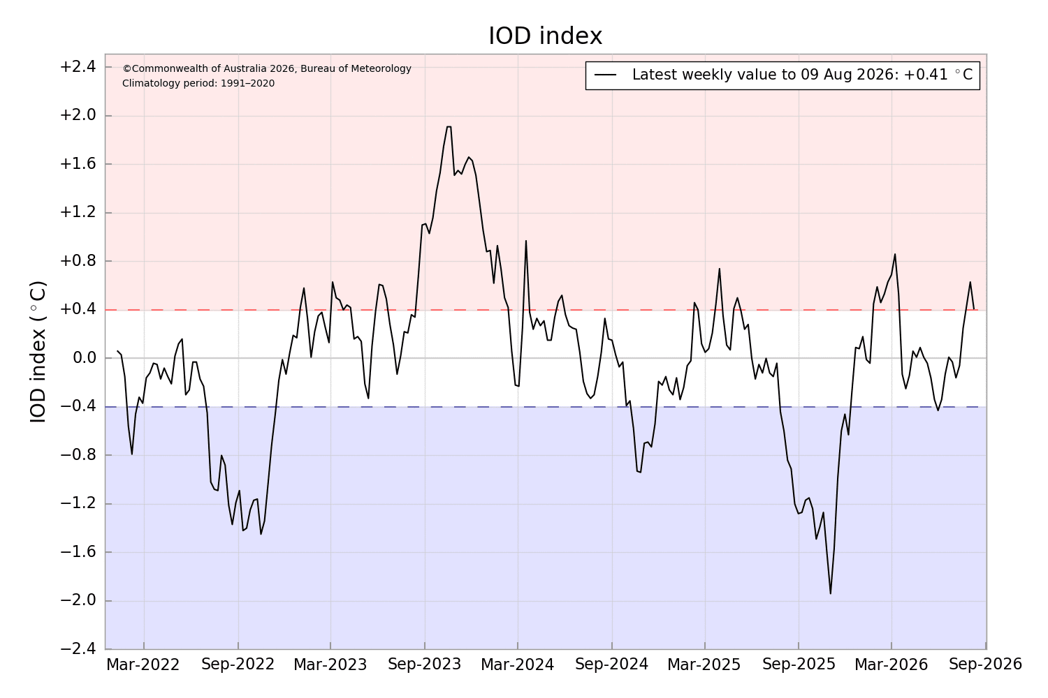
IOD: The Indian Ocean Dipole is currently neutral. The weekly IOD index for the week ending 09th Aug 2026 was +0.41°C. This is the third consecutive week that the index has reached the positive IOD threshold (+0.4°C). But there is no consistency, as the index has dropped significantly from its previous week's mark of +0.63°C. The index needs to sustain a value well above the threshold before the event is considered established. Models do indicate the development of a positive IOD, but uncertainty remains about the timing and strength.
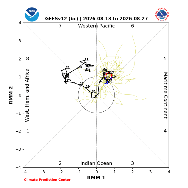
MJO: The Madden-Julian Oscillation has been meandering over the Western Pacific, remaining mostly in Phase 6. The signal will retain modest amplitude till the end of August. A constructively interfering MJO favours enhanced chances of tropical cyclone development across much of the Western Pacific. Even after the powerful strike of Typhoon Dolphin over the South Coast of China, the Western Pacific remains loaded with potential storms and invest areas.
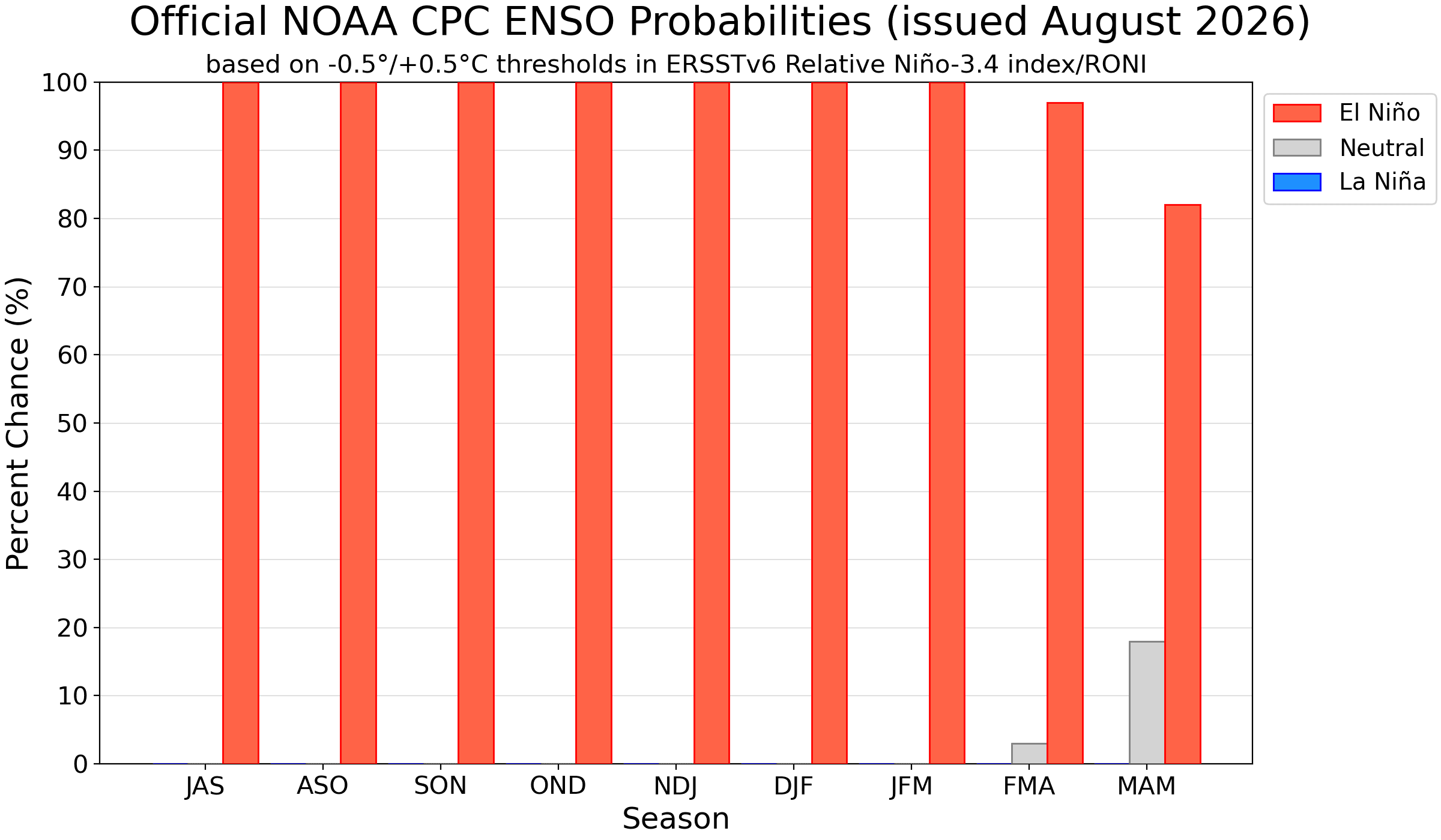
Currently, El Nino is still in the developing stage and is expected to peak post-October 2026 and persist through early spring of 2027. There is a heightened risk of weaker rains in the terminal monsoon period, that is, Sep/Oct 2026. The Western Pacific, laden with potential storms, continues to malign and unsettle the monsoon wind flow over the Bay of Bengal.



