Low Pressure Area Over Arabian Sea Soon: May Become First Tropical Storm Of The Year


A cyclonic circulation is marked over the east-central Arabian Sea, off the north coastal Karnataka and Goa. Under its influence, a low-pressure area is likely to form very soon. Currently, the invest area is centered around 16.5°N and 71.5°E, about 500km southeast of Mumbai. It is likely to become a depression tomorrow and intensify further.
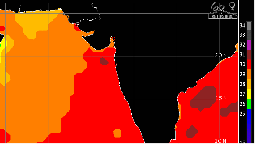
The tropical storms forming over this region around this point in time are rather ambiguous. The clarity about their track, intensity, and the timelines comes much later. These systems have a tendency to meander for some time over that area before settling their travel over the sea. Also, there is a large temperature differential over the Northeast Arabian Sea, off South Pakistan and the Saurashtra & Kutch Coast.
That part of the sea is colder than the rest by nearly 2°C. This temperature profile may not allow an explosive growth of the system and, on the contrary, may weaken a little over the deep sea itself. More clarity will come after the weather system becomes a depression.
Under the influence of low pressure and later on the depression, heavy rains are likely over Konkan, South Coastal Gujarat, and South Coastal Saurashtra over the next 3-4 days. Because of the presence of an anticyclone and the ridge over the North Arabian Sea in the higher tropospheric levels, the drift of these cyclones remains dubious. The steering current over that region leaves a lot of uncertainty. Therefore, the tropical storm, if it forms, will remain susceptible to striking Yemen-Oman, the Pakistan Coast, and Saurashtra & Kutch. The depression will need to be observed closely for further prognostication. The potential of the system to become a cyclone in the next 36 hours is low.