

Air Turbulence: Most Dangerous Weather Hazard For Aviation


Representational Image: AI-Skymet
Key Takeaways:
- Air India flight AI2379 encountered severe convective turbulence over the Bay of Bengal, injuring 17 people.
- The incident is under DGCA investigation using cockpit voice and flight data recorders.
- Convective turbulence associated with monsoon thunderstorms is the most likely cause of the event.
- Pilots use onboard radar, pilot reports and weather advisories to minimize turbulence risk, but no system can detect every hazard.
Advertisement
The Airbus A320neo, operating flight AI2379 from Phuket to Delhi, encountered severe turbulence on 04 Aug 2026 while flying over international waters, just short of entering Indian domestic airspace.
Advertisement
The flight was carrying 137 passengers and 8 crew members. The exact ground position of the aircraft when turbulence struck was outside Indian airspace, over international waters, shortly before it was scheduled to cross into the Indian mainland.
The adverse weather lasted for about five minutes, during which the aircraft nearly stone-dropped, losing 300 feet of altitude during the cruise phase over the Bay of Bengal, just before the plane reached the skies above Odisha.
The incident injured 17 people on board: 13 passengers and 4 crew members.
The incident is now under investigation, with the DGCA examining both the cockpit voice recorder and the flight data recorder to ascertain the details of the incident.
An aircraft experiencing severe turbulence does not necessarily make it an accident. Any occurrence, other than an accident, associated with the operation of an aircraft that could affect the passengers and the safety of aircraft operations is broadly categorized as an "incident".
Turbulence in aviation falls into three broad categories.
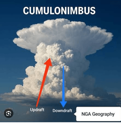
Convective turbulence is generated inside and around thunderstorms due to strong updrafts and downdrafts within the thunderstorm cell and its periphery. The rate of ascent in the updrafts could be as much as 80–100 feet per second.
Clear-air turbulence (CAT) is generated by vertical wind shear, more often in the jet stream, at cruising altitudes in cloudless air.
Mountain-wave turbulence is produced when stable air rises along the mountain slopes due to differential heating of the air mass, resulting in anabatic winds. Anabatic winds are warm upslope breezes driven by daytime solar heating, while katabatic winds are cold downslope gravity flows created by nighttime surface cooling.
Any type of turbulence can be classified into four categories: Light, Moderate, High and Severe.
The case in point here seems to be convective turbulence.
There were no mountains over the area of the incident, and the jet stream is least located on this route, especially during the monsoon season. Therefore, the possibility of the other two types gets practically ruled out.
Advertisement
As such, these two types do not leave any signatures and become rather impossible to detect.
Yes, there are various inputs to read and gauge the scale of convective turbulence, and there are guidelines and procedures in place to avoid the ill effects of the phenomenon.
An airline typically has three layers of information about what lies ahead.
The onboard weather radar—a forward-facing X-band system in the aircraft's nose—detects the density of water particles based on reflectivity. This helps identify the precipitation area, and the position of the convective cells can be inferred.
It does not detect any dry turbulence or CAT.
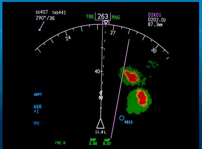
The radar has a limitation of attenuation, in which case a strong cell in the foreground blocks the radar's view of what lies behind it.
In other words, the radar will remain blind to the shadow clouds, if any, hiding behind the tall convective thunderstorm cell.
Pilots trained in monsoon operations are taught to treat the far side of a convective cell as unknown.
The second layer is pilot-to-pilot information through PIREPs (Pilot Reports) and automated EDR (Eddy Dissipation Rate).
The efficacy of this layer depends on the data transmitted by aircraft that have already encountered turbulence on that route.
However, the density of data remains the key factor on any route.
Generally, coverage is denser on transatlantic and transpacific routes, while the Bay of Bengal remains a grey area due to the paucity of traffic, more so for the Phuket–Delhi route.
The third layer is the information and advisories issued by the aviation offices of the National Weather Agency on the respective routes.
Airlines receive these advisories through international teletype networks in real time.
Together, these systems catch most of the turbulence risk, but they do not catch all of it.
The onboard radar misses what it is not designed to detect.
Pilot reports can have gaps in airspace with thin traffic.
Advisories are mostly generic in nature and carry the limitation of lacking specific information with respect to an individual convective cell, particularly for a specific aircraft on a given route.
The Bay of Bengal is a notorious pocket during the monsoon season and remains laden with large areas prone to convective turbulence.
It is a very tough task for pilots to negotiate monsoon thunderstorms spread over vast areas of the ocean surface.
Mind you, there are no diversionary airfields available on such routes in case of an emergency.
Notwithstanding, one must firmly believe that the aircrew, to the best of their knowledge and training, never compromise the comfort and safety of the passengers.
Any untoward incident like this cannot be attributed to dereliction of duty, as passenger safety remains the top concern of the "flying team".
The pending investigations will clear the air, conclusively and decisively.



