The IPL cricket match of Royal Challengers Bangalore with Sunrisers Hyderabad will be played at Rajiv Gandhi International Cricket Stadium, Hyderabad on 25th April from 7:30 PM. The weather may remain a little hot during the match.
The temperature at the beginning of the match will be around 34 degrees. As the match progresses the temperature will drop to 32 degrees. The humidity in the air can be 25 to 40 per cent. Due to less humidity in the air, there is no possibility of dew falling on the field or pitch. Winds will blow from the southeast direction at a speed of 10 to 15 kilometres per hour.
There may be a few clouds in the sky but there is no possibility of rain. Due to low humidity in the air, the sultry heat will not bother you. There is no possibility of rain, so we can say that there will be no hindrance in the match due to the weather.
पिछले 2-3 दिनों में ओडिशा,
पश्चिम बंगाल, झारखंड और छत्तीसगढ़ राज्यों में छिटपुट मौसमी गतिविधियाँ
हुई है, जिस कारण इन भागों में भयंकर गर्मी कम हो गई है। हालाँकि, गर्मी से मिली
यह राहत बहुत ही थोड़े समय के लिए है। क्योंकि बहुत ही जल्द ही आग बरसने वाली स्थितियाँ
बनेंगी। इससे पहले भी पिछले सप्ताह के आखिरी दिनों में पश्चिम बंगाल, ओडिशा, झारखंड और छत्तीसगढ़
के कुछ हिस्सों में भीषण गर्मी पड़ी थी।
बारिश ने दी गर्मी
से राहत: पूर्वी सिंहभूम-झारखंड में रविवार(21 अप्रैल) को
पारा 46 डिग्री सेल्सियस पर पहुंच गया। पश्चिम बंगाल के
बांकुरा, मालदा, पानागढ़, मिदनापुर, पुरुलिया, ओडिशा में अंगुल, बोलांगीर, बारीपदा, टिटलागढ़, संबलपुर और कोरापुट में भीषण गर्मी पड़ी और तापमान 40 के पार पहुंच गया था। हालांकि, पिछले कुछ दिनों
में तापमान में 3-4 डिग्री सेल्सियस की
गिरावट हुई है। जिससे कुछ स्थानों पर तापमान 40 डिग्री सेल्सियस से नीचे जाने से
राहत मिली है।
ओडिशा, बंगाल में बढ़ेगा
तापमान: उत्तरी मध्य महाराष्ट्र से लेकर कर्नाटक होते हुए
केरल तक एक ट्रफ/हवा का विच्छेदन बना हुआ है। वहीं, मध्य महाराष्ट्र और मराठवाड़ा के कुछ हिस्सों पर एक अंतर्निहित
चक्रवाती परिसंचरण(embedded cyclonic circulation) है। यह कमजोर प्रणाली अलग हो जाएगी और पूर्व की ओर बढ़ जाएगी।
अगले 3-4 दिनों में बारिश और गरज के साथ बौछारें विदर्भ,
पूर्वी मध्य प्रदेश, छत्तीसगढ़ और ओडिशा के कुछ हिस्सों को कवर करते हुए पूर्व की
ओर बढ़ेंगी। लेकिन, उत्तरी ओडिशा और पश्चिम बंगाल इस बार प्री-मानसून गतिविधि से बच
जायेंगे। इसलिए अगले 3-4 दिनों में केंद्रीय राज्यों में तापमान कम हो सकता
है। लेकिन, पूर्वी भागों में अभी भी तापमान बढ़ेगा, लेकिन सबसे
ज्यादा ओडिशा और पश्चिम बंगाल में तापमान बढ़ेगा।
मई में तापमान 45°Cतक: मौसमी गतिविधियों का मौजूदा दौर 28 अप्रैल के बाद समाप्त हो जाएगा। भरपूर धूप के कारण
ओडिशा और पश्चिम बंगाल के आंतरिक भागों में शुष्क गर्मी बढ़ेगी। अप्रैल के आखिरी दिनों
और मई के पहले सप्ताह में कई स्थानों पर पारे का स्तर लगभग 45°C तक बढ़ सकता है। इन दोनों राज्यों के कुछ इलाकों
में भीषण गर्मी पड़ने की संभावना है। मालदा, बांकुरा, कोलकाता, हावड़ा, मिदनापुर, बर्दवान, पानागढ़ और पुरुलिया में तापमान की सामान्य सीमा
5-7 डिग्री सेल्सियस से अधिक हो जाएगी।
भयंकर लू का खतरा: टिटलागढ़, संबलपुर, मलकानगिरी, कोरापुट, बोलांगीर, अंगुल और क्योंझरगढ़
तक फैले ओडिशा के अंदरूनी इलाकों में भी ऐसी ही स्थिति होगी। भीषण गर्मी आगे बढ़कर कटक, भुवनेश्वर, बारीपदा, राउरकेला और रायगड़ा तक पहुंच सकती है। भीषण गर्मी
का दौर इस बार लंबा चलने की संभावना है। दरअसल, देश के मैदानी इलाकों में पूर्व से पश्चिम और उत्तर से दक्षिण
तक देश के अधिकांश हिस्से लू की चपेट में रहेंगे। यहां तक कि पश्चिमी तट के बड़े हिस्सों में लू की स्थिति का
खतरा रहेगा।
पश्चिमी विक्षोभ के अवशेष उत्तरी पहाड़ों के मध्य
और ऊंचे इलाकों में अलग-अलग मौसमी गतिविधियाँ दे रहे हैं। उत्तर भारत के मैदानी इलाकों
में मौसम साफ-सुथरा है। पिछले दो दिनों में हुई भारी मौसम गतिविधि के कारण दिन का तापमान
सामान्य से काफी नीचे गिर गया। पठानकोट, अमृतसर, जालंधर, लुधियाना, पटियाला, अंबाला, करनाल और कई अन्य स्टेशनों का तापमान औसत से 4-6 डिग्री सेल्सियस नीचे चला गया है। आसमान साफ़ रहने
की स्थिति में अगले 2 दिनों में तापमान बढ़ने और उसके बाद फिर से कम
होने की उम्मीद है।
बारिश की बन रही मौसम प्रणाली: 26 अप्रैल को जम्मू-कश्मीर क्षेत्र में एक नया पश्चिमी
विक्षोभ आ रहा है। इसका प्रेरित परिसंचरण मुख्य प्रणाली से पहले होगा। 25 अप्रैल को दक्षिण-पश्चिम पाकिस्तान और इससे सटे
पश्चिमी राजस्थान पर स्थित होगा। उत्तर मध्य महाराष्ट्र से ट्रफ का उत्तर की ओर विस्तार
इस सिस्टम से जुड़ेगा। जिससे गुरुवार को दक्षिणपूर्व राजस्थान, उत्तरी गुजरात और दक्षिण-पश्चिमी मध्य प्रदेश में
बारिश और गरज के साथ बारिश होगी।
तूफान के साथ ओलावृष्टि: मुख्य मौसम प्रणाली 26 अप्रैल को आएगी। इन दोनों प्रणालियों के संयुक्त असर से 26 अप्रैल को पंजाब, हरियाणा, चंडीगढ़, दिल्ली, पूर्वी राजस्थान और उत्तरी मध्य प्रदेश में एक साथ मौसम गतिविधि( बारिश, आँधी, तेज हवा, ओलावृष्टि) होगी। तेज़ हवाओं के साथ बड़े क्षेत्रों में तूफान की स्थिति बनने की संभावना है। वहीं, पंजाब और हरियाणा के कुछ इलाकों में ओलावृष्टि की आशंका है। बड़े क्षेत्र में तूफानों के साथ गड़गड़ाहट और बिजली की चमक भी होगी।
मई में बढ़ेगा पारे
का स्तर: महाराष्ट्र ट्रफ 27 अप्रैल को अलग हो जाएगी और पूर्वी मध्य प्रदेश, विदर्भ, छत्तीसगढ़ से होकर गुजरेगी। उत्तरी भागों
में मौसम की गतिविधि 27
अप्रैल को पंजाब, हरियाणा, चंडीगढ़ के पहाड़ों और
तलहटी तक सीमित हो जाएगी। मौसम प्रणाली राजस्थान और दिल्ली को खाली कर देगी। इसके
बाद 28 अप्रैल को बारिश की तीव्रता और कम हो जाएगी। इसके बाद मैदानी इलाकों में
बारिश में लंबा ब्रेक लगेगा। जिससे अप्रैल के आखिरी दिनों और मई की शुरुआत में पारे
का स्तर बढ़ने की संभावना है। इस अवधि के दौरान देश के इन हिस्सों में 40 डिग्री सेल्सियस तक तापमान पहुंचने का पहला दौर
शुरू होने की संभावना है।
Courtesy, scattered weather activity over states of Odisha, West Bengal, Jharkhand and Chhattisgarh over the last 2-3 days, extreme heat abated these parts. However, the relief is short and sweet, as the conditions will build up to have the blaze, yet again. Earlier, during the last weekend, severe heat prevailed in pockets of West Bengal, Odisha, Jharkhand and Chhattisgarh. Mercury touched 46°C in East Singhbhum-Jharkhand on Sunday. Bankura, Malda, Panagarh, Midnapore, Purulia in West Bengal and Angul, Bolangir, Baripada, Titlagarh, Sambalpur and Koraput in Odisha braced soaring heat with temperature rising to mid 40’s. There was conciliatory relief over the last few days with temperatures sliding 3-4°C and dropping even below 40°C at a few places.
There is a trough/ wind discontinuity extending from North Madhya Maharashtra to Kerala, across Karnataka. This feature has an embedded cyclonic circulation over parts of Madhya Maharashtra and Marathwada. This feeble system will get detached and move eastward. Rain and thundershower activity will move eastward covering Vidarbha, East Madhya Pradesh, Chhattisgarh and parts of Odisha over the next 3-4 days. North Odisha and West Bengal will escape the pre-monsoon activity, this time. Therefore, the temperatures may ease out over the central states for the next 3-4 days but the eastern parts and more so, Odisha and West Bengal will still have a rising trend.
The current spell of weather activity will cease after 28th April. Plenty of sunshine will build up the dry heat over the interior parts of Odisha and West Bengal. Mercury level may rise to about 45°C at many places during the last days of April and the first week of May. Severe heat wave is likely in some pockets of these two states. Malda, Bankura, Kolkata, Howrah, Midnapore, Burdwan, Panagarh and Purulia will exceed their normal range of temperature by 5-7°C. Interiors of Odisha spanning Titlagarh, Sambalpur, Malkangiri, Koraput, Bolangir, Angul and Keonjhargarh will also have similar conditions.
The extreme heat may even extend and reach Cuttack, Bhubaneshwar, Baripada, Rourkela and Rayagada. Spell of severe heat may get prolonged this time. Spread and intensity will be large. Most parts of the country will be swept by heatwave conditions from east to west and north to south, across plains of the country. Even, the West Coast will be at risk of observing heat wave conditions over bigger pockets.
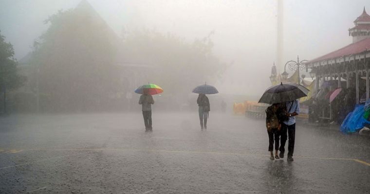
23 अप्रैल को शाम के समय दिल्ली और उसके आसपास के इलाकों में धूल भरी आँधी के साथ तेज बारिश की गतिविधियां देखने को मिली। 24 अप्रैल को शाम 7:30 बजे से दिल्ली के अरुण जेटली क्रिकेट स्टेडियम में दिल्ली कैपिटल्स के साथ गुजरात टाइटंस का आईपीएल क्रिकेट मैच खेला जाएगा। यह अच्छी बात है कि आज 24 अप्रैल को बारिश की संभावना दिल्ली में नजर नहीं आ रही है।
मैच के शुरुआती दौर में दिल्ली का तापमान 34 डिग्री के आसपास रहेगा, जो धीरे-धीरे कम होते हुए 29 डिग्री तक पहुंच जाएगा। आसमान लगभग साफ बना रहेगा। साथ उत्तर पश्चिम दिशा से 8 से 15 किलोमीटर प्रति घंटा की रफ्तार से हवाएं चलती रहेगी। हवा में नमी काफी कम रहेगी, जो 20 से 30% तक हो सकती है। कम नमी होने के कारण मैदान या पिच के ऊपर ओस गिरने की संभावना नहीं है।
अरुण जेटली क्रिकेट स्टेडियम की पिच धीमी है और स्पिनर्स के लिए अच्छी है। वहीं, मैदान छोटा होने के कारण बैट्समैन निश्चित होकर के शॉर्ट खेल सकते हैं। जिससे बल्लेबाज बड़ा और अच्छा स्कोर कर सकते हैं। मौसम के कारण के मैच के दौरान किसी भी रुकावट की संभावना दिखाई नहीं दे रही है। मैच पूरे ओवर के साथ समाप्त होगा।
Remnant of the western disturbance is giving isolated weather activity over mid and higher reaches of northern mountains. Plains of north India have fair weather conditions across the region. Due to fairly widespread weather activity over the last two days, the day temperatures dipped below normal significantly. Pathankot, Amritsar, Jalandhar, Ludhiana, Patiala, Ambala, Karnal and many other stations have plunged 4-6°C below the average. With clear sky conditions, these are expected to rise over the next 2 days and drop again, thereafter.
A fresh western disturbance is arriving on 26th April over the Jammu & Kashmir region. Its induced circulation will precede the main system and lie over Southwest Pakistan and adjoining West Rajasthan on 25th April. The northward extension of the trough from North Madhya Maharashtra will connect with this system to cause rain and thunderstorms on Thursday over Southeast Rajasthan, North Gujrat and Southwest Madhya Pradesh.
The main system arrives on 26th April. The combined influence of these two systems will cause simultaneous weather activity over Punjab, Haryana, Chandigarh, Delhi, East Rajasthan and North Madhya Pradesh on 26th April. There is the likelihood of stormy conditions over wide areas, accompanied by strong gusty winds. A hailstorm is expected over some areas in Punjab and Haryana. Peals of thunder and flash of lightning will accompany the convective storms over a large area.
Maharashtra trough will get detached on 27th April and move across East Madhya Pradesh, Vidarbha and Chhattisgarh. Over the northern parts, the weather activity will get confined to the mountains and foothills of Punjab & Haryana and Chandigarh on 27th April. It will vacate Rajasthan and Delhi areas shrink further in intensity and spread on 28th April. This will be followed by a long break in weather activity over the plains. Mercury level is likely to spike during the last days of April and the start of May. The first bout of 40°C over this part of the country is quite likely during this period.
On the evening of 23 April, heavy rain activities along with duststorms were seen in Delhi and its surrounding areas. The IPL cricket match of Gujarat Titans with Delhi Capitals will be played at the Arun Jaitley Cricket Stadium in Delhi on 24th April from 7:30 PM. It is a good thing that there is no possibility of rain in Delhi today 24th April.
In the initial phase of the match, the temperature in Delhi will be around 34 degrees which will gradually reduce to 29 degrees. The sky will remain almost clear and winds will blow from the north-west direction at a speed of 8 to 15 kilometers per hour. The humidity in the air will be very low, it can be 20 to 30%.
Due to low humidity, there is no possibility of dew falling on the field or the pitch. The pitch at Arun Jaitley Cricket Stadium is slow and good for spinners. But due to the small field, batsmen can confidently play short and score a big score. There is no possibility of any interruption during the match due to weather and the match will end with full overs.
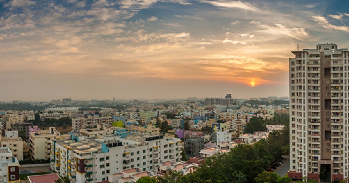
इस प्री मॉनसून सीज़न के दौरान राजधानी बेंगलुरु
पूरी तरह से शुष्क रही है। दरअसल, यह सिलसिला बहुत पहले
ही शुरू हो गया था, जब सर्दियों के
महीने जनवरी और फरवरी में भी सूखा रहता था। जनवरी के पहले सप्ताह में हल्की बारिश और
उसके बाद सूखा। फिलहाल, बेंगलुरु में पानी का संकट जारी रहने की संभावना है,
क्योंकि अप्रैल में राहतभरी बारिश की भी कोई उम्मीद
नहीं है।
बेंगलुरु में बारिश की 99% कमी: इससे पहले, प्री-मानसून प्रायद्वीपीय भारत ट्रफ़ ने पिछले सप्ताह सक्रिय होने के संकेत दिखाए थे। कुछ समय के लिए मौसम में बदलाव आया था। हालाँकि, बेंगलुरु शहर आज तक जलविहीन है। बेंगलुरु ग्रामीण और शहरी दोनों में वर्षा की कमी 99% है। पठारी शहर के आसपास के कई अन्य हिस्सों का भी यही हाल है और भविष्य में जल्द इस स्थिति के बेहतर होने की संभावना नहीं है।
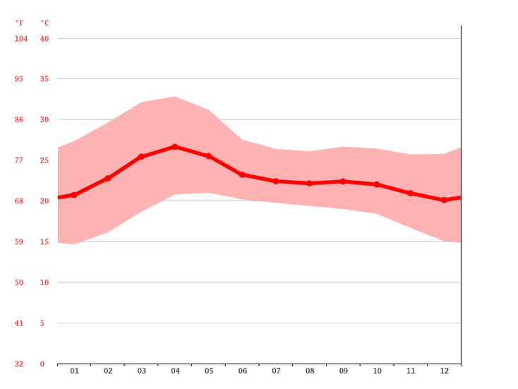
बैंगलुरु का पीएफए औसत मासिक तापमान
इन क्षेत्रों में
भी मौसम की मार: प्रायद्वीपीय तटरेखा
के दोनों ओर प्रतिचक्रवात (anticyclone) ने मौसमी ट्रफ को उसकी सामान्य स्थिति से बहुत दूर पश्चिम की
ओर धकेल दिया है। मौसम की जो भी गतिविधि होगी, वह सिर्फ केरल, तटीय कर्नाटक, उत्तरी कर्नाटक और मध्य महाराष्ट्र राज्य तक ही सीमित
रहेगी। बेंगलुरु, मैसूरु, मांड्या, हसन, चामराजनगर और तुमकुर
भी मौसम की मार से जूझ रहे हैं।
बारिश नहीं होने सेभीषण गर्मी: लंबे समय से बारिश नहीं होने के कारण गर्मी बढ़ गई है और पारा औसत मानदंडों से
ऊपर चला गया है। बेंगलुरु में गर्मी ज्यादा बढ़ने वाली है, सप्ताहांत के आसपास
तापमान 30 डिग्री सेल्सियस के उच्चतम स्तर तक पहुंच
सकता है। अप्रैल का महीना मई की तुलना में अधिक गर्म माना जाता है। इस समय,
बेंगलुरु शहर चरम गर्मी से गुजर
रहा है। हालांकि, मई के पहले सप्ताह के बाद काफी हद तक राहत मिलने की संभावना है।
मुंबई ने 16 अप्रैल को पारे का दस साल पुराना
रिकॉर्ड तोड़ दिया था। 16 अप्रैल को मुंबई में 39.7 डिग्री सेल्सियस तापमान दर्ज किया गया, जो सामान्य से लगभग 7 डिग्री सेल्सियस अधिक था। बता दें, दस साल पहले अप्रैल
2014 में मुंबई का तापमान 39 डिग्री सेल्सियस रिकॉर्ड किया गया था। तटीय शहर मुंबई
में कल 22 अप्रैल को अधिकतम तापमान 34.8 डिग्री सेल्सियस दर्ज किया गया, जो सामान्य से लगभग एक डिग्री अधिक है। जैसे-जैसे सप्ताहांत नजदीक आएगा,
तापमान ज्यादा बढ़ने की संभावना है। तापमान आने
वाले सप्ताह तक भी बढ़ सकता है।
लू चलने की संभावना: जब भी पारा 37 डिग्री सेल्सियस को पार करता है तो मुंबई जैसे तटीय शहर लू
की चपेट में आ जाते हैं। इस सीज़न में ऐसा केवल एक बार हुआ है और दोबारा होने की संभावना
है। अप्रैल महीने के अंत में तापमान बढ़ने की संभावना है और यह लू के निशान से भी ऊपर
जा सकता है।
हल्की बूंदाबांदी
की संभावना: एक उत्तर-दक्षिण ट्रफ रेखा विदर्भ-मराठवाड़ा से
केरल तक फैली हुई है, जो उत्तर आंतरिक कर्नाटक,
गोवा और तटीय कर्नाटक से होकर गुजर रही है। कल 22 अप्रैल को पूरे ट्रफ क्षेत्र में छिटपुट मौसमी गतिविधियां
देखने को मिलीं थी। आज भी ऐसे ही पैटर्न की उम्मीद है। ट्रफ रेखा कल 24 अप्रैल को कोंकण
तट के थोड़ा करीब पहुंचेगी। जिससे मुंबई, ठाणे, रायगढ़ क्षेत्र में छिटपुट बादल छाए रहेंगे और हल्की
बूंदाबांदी की संभावना है। बारिश अगर होगी भी तो
कोई सुखद स्थिति देने के लिए पर्याप्त नहीं होगी। शहर और
उपनगर गर्म व आर्द्र(humidity) परिस्थितियों में झुलसते
रहेंगे।
ऐसा रहेगा मुंबई का
मौसम: मुंबई में सामान्य प्री-मानसून बारिश अभी भी दूर
है। बता दें, देश की वित्तीय राजधानी मुंबई का तापमान मार्च, अप्रैल और मई महिने में 40 डिग्री सेल्सियस के पार जाने का ट्रैक रिकॉर्ड है।
मुंबई में मानसून का स्वाद जून में ही आता है, तब तापमान 30 के मध्य तक गिर जाता है। मई के महीने में कभी-कभी छिटपुट गरज
के साथ बारिश होने की संभावना रहती है। राहत आने से पहले मुंबईकरों को अगले एक महीने
तक गर्मी और उमस से जूझना होगा।
The capital city of Bengaluru has remained completely dry during this pre-monsoon season. Actually, the trail started much earlier, when the city remained parched during the winter months of Jan and Feb as well. Slight fleeting showers in the first week of Jan and a drought thereafter. Water woes are likely to continue, as there are hardly any hopes, even on the horizon for conciliatory showers in April.
Earlier, the pre-monsoon Peninsular India trough showed signs of activation last week. There was a twist in the weather conditions for a brief period. However, the city remained waterless, till date. Both, Bengaluru rural and urban have a rainfall deficiency of 99%. Many other pockets surrounding the plateau city have a similar fate and are unlikely to be better, anytime soon.
The anticyclone on either side of the Peninsular coastline has pushed the seasonal trough, far to the west of its normal position. Whatever weather activity, it is confined to the state of Kerala, Coastal Karnataka, North Karnataka and Madhya Maharashtra. Bengaluru, Mysuru, Mandya, Hassan, Chamrajnagar and Tumkur are fighting the odds of weather.
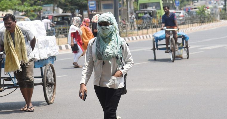
The long absence of rains have led to the accumulation of heat and mercury rising above the average norms. Heat is going to catch up further and the temperature may reach in high 30’s, around the weekend. The month of April is considered a shade hotter than May. Right now, the city is going through the peak heat and is likely to ease out significantly after the first week of May.
पिछले 3 दिनों से दिल्ली का
तापमान लगातार बढ़ रहा है। कल 22 अप्रैल को सफदरजंग वेधशाला में अधिकतम तापमान 37.6 डिग्री सेल्सियस दर्ज किया गया, जो सामान्य के करीब है। इसी तरह के तापमान का
स्तर पालम और लोधी रोड स्थित मौसम कार्यालय में देखी गई। दिल्ली में 19 अप्रैल को
अब तक का सबसे अधिक तापमान 39.4 डिग्री सेल्सियस दर्ज
किया गया है। वहीं, इस सप्ताह के दौरान पारे का स्तर बढ़ने की संभावना है, जिसके
इस सीजन में पहली बार 40 डिग्री सेल्सियस के पार जाने की संभावना है।
41 डिग्री पारा पहुंचने की आशंका: दिल्ली में 25 मई 2024 को छठे चरण में मतदान होगा, इस समय प्री-मानसून गर्मी चरम पर होगी। हालाँकि, नोएडा और गाजियाबाद सहित एनसीआर के कुछ हिस्सों में 26 अप्रैल 2024 को मतदान होगा। उत्तर प्रदेश के गौतमबुद्धनगर, गाजियाबाद, बागपत, बुलंदशहर, मेरठ और अमरोहा के निर्वाचन क्षेत्रों में इस दिन, 26 अप्रैल को मतदान होगा। बता दें, इनमें से किसी भी स्थान पर अब तक तापमान 40 डिग्री सेल्सियस तक नहीं पहुंचा है। इन सभी क्षेत्रों में तापमान 39 डिग्री सेल्सियस पर ही रुका हुआ है। मतदान के दिन यानी 26 अप्रैल को इन सभी स्थानों और दिल्ली में तापमान 40 डिग्री सेल्सियस से ऊपर जाने की आशंका है। बता दें, आने वाले दिनों में पारा और बढ़ सकता है। जो सप्ताहांत के आसपास 41°C तक पहुंच सकता है।
कई हिस्सों में लू चलने की आशंका: लू उत्तर भारत के पहाड़ों पर 26 अप्रैल को एक नया पश्चिमी विक्षोभ आने की संभावना है। साथ ही, पंजाब और राजस्थान के कुछ हिस्सों पर कमजोर चक्रवाती परिसंचरण (feeble cyclonic circulation) होगा। 26 अप्रैल के दिन पंजाब, हरियाणा और चंडीगढ़ में हल्की और छिटपुट मौसमी गतिविधियां होने की संभावना है। वहीं, दिल्ली इस मौसम प्रणाली की पहुंच से काफी दूर होगी। अगर सिस्टम के सभी बाहरी परिधीय एनसीआर क्षेत्र में पहुंच जाते हैं, तो मतदान का समय समाप्त हो जाएगा। दिन के दौरान, दोपहर के समय तेज घूप और तापमान 40 डिग्री सेल्सियस या उससे ऊपर बढ़ने की उम्मीद है। अप्रैल के आखिर औऱ मई की शुरुआत के दौरान देश के अधिकांश हिस्सों में गर्मी बढ़ जाएगी। मई के पहले सप्ताह में कई हिस्सों में लू और कुछ हिस्सों में भीषण लू चलने की आशंका है।
Mumbai had earlier thrashed a decade-old record of mercury on 16th April. The city recorded a scalding temperature of 39.7°C, about 7°C above normal and surpassing decade old record of 39°C in April 2014. The coastal city recorded a maximum of 34.8°C yesterday, about a notch above the normal. Temperature is likely to rise further, as the weekend approaches and may as well spill over to the next week.
The coastal towns like Mumbai come in for heat waves as and when mercury crosses the 37°C mark. It has happened only once this season and a repeat is likely. Temperature is likely to ascend and may rise beyond the heat wave mark, during the fag end of the month.
A north-south trough is extending from Vidarbha-Marathwada to Kerala, running across North Interior Karnataka, Goa and Coastal Karnataka. There has been scattered weather activity all along the trough yesterday. A similar pattern is expected today, as well. The trough will shift a little closer to the Konkan coast tomorrow. Mumbai, Thane, and Raigad areas will have scattered clouds and some chance of light and fleeting drizzle. The rain, if at all, will not suffice to provide any soothing conditions. The city and suburbs will continue to sizzle and sulk under warm and humid conditions.
Typical pre-monsoon rains are still away for the city. The financial capital of the country has a track record of breaching the 40°C mark in March, April and May. Monsoon flavour arrives in June only when the temperatures dip to mid-30s. There are chances of sporadic thunderstorm activity, occasionally in the month of May. Mumbaikars have to bear with the hot and sultry conditions for another month or so before the relief arrives.