Southwest Monsoon has failed to kick start with its normal style for the state of Kerala. June is the 2nd best rainiest month of the season with 643mm of normal rainfall. The 1st two months of June and July record nearly double the rainfall than the 2nd half of August and September. Mostly, the monsoon announces its arrival with a deluge in the opening days. Contrary to this pattern, the monsoon made a soft landing and is deficient by 48% in the 1st week.
Except on the 1st day, the rainfall deficiency has been piling up and getting accumulated on daily basis. All the districts of the state, without any exception, have recorded less than the average rainfall.
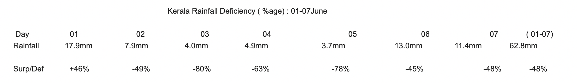
The state has recorded actual rainfall of 62.8mm against the normal of 120.6mm, deficit by -48%. The northern half of state is more deficit than the south. 5 out of 14 districts are ‘ large deficit’ : namely Kannur, Idukki, Kasaragode, Palakkad, Wayanad. Malappuram and Pathanamthitta are the only 2 districts with marginal deficiency of 19% and 4% respectively.
There is no major monsoon surge likely for the state. Weak phase of the monsoon is expected to continue, at least for one more weak or even longer. Typical monsoon rains pick up over the state with either the formation of ‘monsoon low /depression’ over Bay of Bengal or an off shore vortex over Lakshadweep area. There is a cyclonic circulation over central Bay of Bengal in the medium levels but unlikely to percolate to the surface to trigger surge. Also, there are no indications of any likely vortex over Southeast Arabian Sea, Comorin Sea and Lakshadweep region. Rainfall deficiency will increase further and the recovery looks difficult.