The Pacific Ocean cooling has led to the commencement of La Nina watch. The Climate Prediction Centre(CPC) issues a bulletin indicating conditions favourable for the development of La Nina/ El Nino with a notice period of six months. The CPC considers La Nina conditions to occur when the monthly Nino3.4 region sea surface temperature (SST) departures meet or exceed -0.5°C along with consistent atmospheric features. These anomalies must also be forecasted to persist for 3 consecutive months.
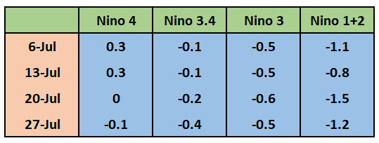
El Nino/ La Nina is a coupled interaction of the atmosphere with the ocean currents resulting in warming/cooling of SST in the central and eastern Pacific Ocean. Nino indices are measured over a large area of 1.2million sq.km over the Pacific Ocean. Prominently four Nino indices are monitored through a range of data collection platforms including space-based sensors. Nino 3.4 region is considered for El Nino/ La Nina monitoring, tracking, and predicting the event.
From July-Sep 2019, below-average SST’s expanded westward into the east-central Pacific. Since early May 2020, equatorial SST’s were near to below average in the east-central and eastern Pacific Ocean. The surface and subsurface of the tropical Pacific Ocean cooled significantly. The climate models anticipate further cooling in the coming months with the majority of models exceeding the La Nina threshold during the fall of the year. The probability of El Nino is negligible during the monsoon months and is merely 10% even during the fall of the year. The probability of La Nina continues to increase albeit at the behest of neutral, which drops to about 40% towards the end of the season.
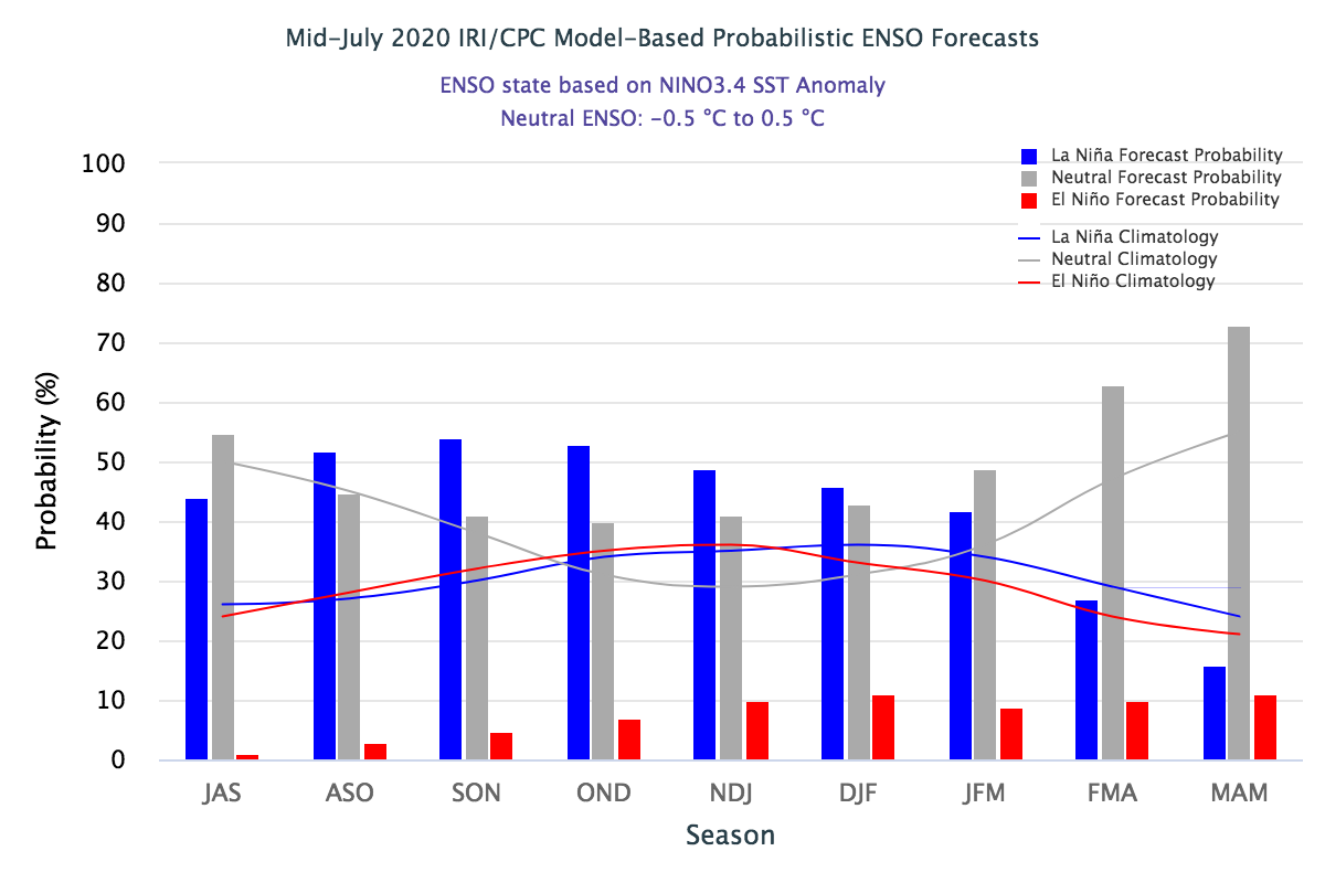
The Nino indices are consistently dropping to record negative values now. As a consequence of tropical Pacific cooling, the La Nina watch has commenced. The ENSO neutral is favored to continue through the monsoon, with a 50-55% chance of La Nina development during the Northern Hemisphere fall 2020 and continuing through winter 2020-21.
Pacific conditions seem to be drifting towards a La Nina event later in the year and thus bailing out monsoon from its clutches. El Nino/ La Nina conditions do have a connection with the Northeast Monsoon and winter rains over northern parts.
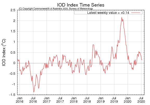
Another important oceanic index is the Indian Ocean Dipole (IOD), also called the Indian Nino. IOD is a coupled ocean/ atmosphere phenomenon. The intensity of IOD is represented by anomalous SST gradient between Western Equatorial Indian Ocean( 50-70°E/ 10°S-10°N) and South Eastern Equatorial Indian Ocean( 90-110°E/ 10°S-10°N). This gradient is termed as DMI(Dipole Mode Index). The positive values of DMI correspond to the active and +ve IOD and the negative score of DMI relates to sleeping IOD. Unlike El Nino, the occurrence of IOD is erratic and its forecast also not quite reliable. Last year there was never a forecast of strong +ve IOD but its record value of nearly 2°C swayed the monsoon to go in large excess with 110% of LPA. Even this year, a -ve IOD forecast during the monsoon does not seem to be holding. Much of the eastern Indian Ocean through warmer than average, the possibility of a negative IOD developing during the monsoon is highly unlikely. The state of IOD through neutral but is having a consistent positive disposition. The index may touch or even cross the threshold mark of +0.4° during the later part of the season. The latest value is +0.2°C. A positive IOD is invariably poised for enhancing the monsoon rainfall.
Just for academic interest, two things are rare in the case of IOD: the occurrence of consecutive +ve IOD and a +ve IOD together with La Nina. From the historic records, it is also inferred that IOD episodes occur in the ratio of 1:1:3, which means one positive, one negative, and three neutral. Since 1960, when reliable records of the IOD began to 2019, there are 12 +ve, 12 -ve, and rest neutral events. The southwest monsoon is nearly halfway through and season rainfall stands at normal recording 425mm against normal of 424mm.