La Nina Conditions May Weaken In The Next Quarter

The IRI multi-model average predicts weak La Nina conditions to continue through Feb-Mar-Apr 2025 and then transition to ENSO-Neutral. The disparity between the statistical and dynamical models on the emergence of La Nina remains a concern. The IRI dynamical model-average and NMME-Multi-Model Ensemble predict an earlier than normal transition to ENSO-Neutral. Yet, there is a broad agreement amongst the models for the La Nina event to be weak and brief. A weak La Nina is less likely to result an adverse impact on the conventional winter, followed by spring in the Northern Hemisphere.

ENSO: The Oceanic Nino Index (ONI) reached the threshold mark of -0.5°C for the first time in the quarter Nov-Dec-Jan. The sea surface temperature has steadily risen in the Nino 3.4 region in February 2025. Despite this warming in the Nino region of the equatorial Pacific, the ONI for the quarter Dec-Jan-Feb may still remain at or above the threshold of -0.5°C. The reason being, that the SST anomaly during Nov 2024 was recorded between 0.0°C and -0.3°C and the index has, though declined, in Feb 2025 from -0.8°C to -0.3°C in the last three weeks, yet, the score of Feb 2025 is better than Nov 2024. Accordingly, the next quarter Dec-Jan-Feb is expected to have ONI meeting the La Nina threshold.


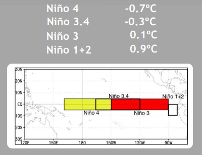
The latest weekly indices were -0.3°C in the Nino 3.4 region and -0.7°C in the Nino 4. These indices were above 0°C in Nino 1+2 and Nino 3. There is a clear divide between the warm eastern half and cool western half of the Nino region. Also, the Nino 3.4 index has nearly collapsed from -0.8°C on 03rd Feb 25 to -0.3°C on 18th Feb 25. Such a steep fall does not augur well for the sustenance of La Niña conditions. Even the equatorial SOI has reached very close to neutral. Collectively, the coupled ocean-atmosphere system indicates La Niña conditions, albeit as a borderline case.

IOD: The Indian Ocean Dipole remains positive for the second consecutive week. The latest value of the index for the week ending 16 Feb 2025 was +0.4°C. The variation of this index is very large around this time of the year. Even with the latest simulation techniques, the IODs are difficult to predict several months in advance. For the Indian monsoon, IOD prediction is needed from summer to autumn (NHS). Moreover, it faces a ‘Winter Prediction Barrier’ like the El Niño has a ‘Spring Barrier.’.

MJO: The Madden-Julian Oscillation remains active amidst an emerging La Niña since the start of 2025. The enhanced phase of the pulse is now crossing the Western Hemisphere and Africa. The propagation is slow but steady and is likely to enter the Indian Ocean at the start of March. Some of the models are indicating weakening and the amplitude to shift within the unit circle. The tropical cyclone formation is likely to continue over the Indian Ocean in the Southern Hemisphere.

The current La Niña event is not without its controversies. The timings are rather unusual for the start of the event. Keeping in mind the variability of the Nino Indices, more so, the marker index Nino 3.4, the sustenance of the event is at stake. In any case, the current episode is expected to be weak. Also, it may go on record to be the shortest duration La Niña.