Cyclone "Senyar" Update: Heavy Rain, Flooding Likely in Southern States


Sat Image: Mosdac.gov.in
KEY TAKEAWAYS
- A strengthening system in the Bay of Bengal is close to becoming Cyclone Senyar.
- Heavy to very heavy rainfall is expected across Andaman & Nicobar, Tamil Nadu, Kerala and coastal Andhra Pradesh.
- Southern Tamil Nadu is already facing flooding, school closures and widespread disruptions.
- The next 48 hours will determine Senyar’s exact track and potential landfall.
A rapidly strengthening weather system in the Bay of Bengal is on track to become Cyclone Senyar, the second named storm of this post-monsoon season. The disturbance began as a low-pressure area over the Strait of Malacca and the South Andaman Sea and has since intensified with a deep cyclonic circulation rising through multiple atmospheric layers. As it moves west-northwestward into the southeast Bay of Bengal, warm waters and supportive atmospheric conditions continue to favour its further development.
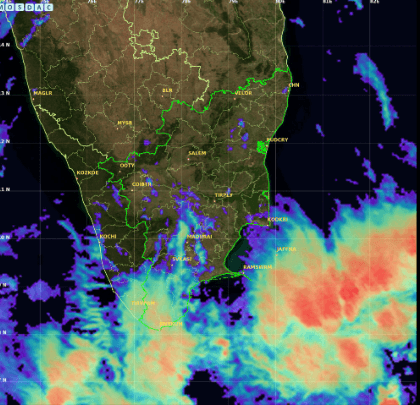
INSAT-3DS imagery shows deep convection building south of Tamil Nadu.
Once it intensifies into a cyclonic storm, it will be named “Senyar”, a name contributed by the UAE to the North Indian Ocean naming list. This comes soon after October’s Cyclone Montha, highlighting an unusually active phase in the region. The name ‘Senyar’, contributed by the UAE, translates to ‘lion’.
Is the Track of Cyclone Senyar Clear Yet?
Not fully. Forecast models still vary, offering two major scenarios—a Tamil Nadu or Andhra Pradesh coast-hugging path around Nov 29–30, or a northward curve that keeps the system offshore and gradually weakens it over the Bay.
This uncertainty is typical for Bay of Bengal storms, which are highly sensitive to upper-air steering changes. A more reliable track is expected within the next 48 hours.

Rain bands from Senyar’s outer spiral approaching Karnataka coast.
Where Will Heavy Rain Occur? (Key Rainfall Zones)
From today, Nov 25 onward, several regions are likely to see heavy to very heavy rainfall as Senyar organizes further.

Thick rain belts covering Andaman & Nicobar Islands this morning.
Andaman & Nicobar Islands will see heavy to very heavy rain between Nov 25–29, with thunderstorms, lightning and winds up to 40–50 km/h. Tamil Nadu is expected to experience widespread heavy rain from Nov 25–30, with intense spells possible as the system draws closer to the southwest Bay of Bengal.
Kerala and Mahe will see intermittent moderate to heavy rain with isolated intense cells. Coastal Andhra Pradesh and Yanam will see an increase in rainfall closer to Nov 29, turning very heavy on Nov 30. Lakshadweep will experience periods of heavy rain and rough sea conditions. Odisha may see isolated heavy spells between Nov 25–27 if the system intensifies and nudges slightly north.
Which Areas Are Currently Most Affected?
Southern India is already experiencing disruptions linked to Senyar’s approach. Persistent rainfall since early morning has led to flooding and waterlogging in multiple districts. Thoothukudi, Tirunelveli and parts of southern Tamil Nadu have reported inundated residential areas and blocked roads. Nagapattinam is witnessing stagnant water in several neighbourhoods, prompting urgent drainage measures.
Rainfall recorded up to this morning (Nov 25):
- Oothu (Tirunelveli): 23 cm
- Nalumukku: 22 cm
- Sethiathope (Cuddalore): 21 cm
- Kakkachi (Tirunelveli): 21 cm
- Manjolai: 19 cm
Schools remain closed today (Nov 25) in Madurai, Ramanathapuram, Thoothukudi, Mayiladuthurai, Thanjavur, Pudukottai, Trichy, Nagapattinam, Sivagangai and Virudhunagar. Holiday declarations are also in effect in Puducherry and Karaikal.
High-risk zones further extend across the Andaman & Nicobar Islands, south coastal Tamil Nadu, Chennai region, Kerala’s western ghats, coastal Andhra Pradesh and Lakshadweep.
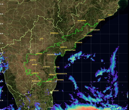
Moisture plume edging toward Andhra Pradesh as Senyar intensifies.
Advice for Residents and Coastal Communities
Residents in vulnerable districts should keep drinking water, power backups, dry food and essential medicines ready. Avoid unnecessary travel during heavy rainfall, especially in hilly regions prone to landslides. Those in low-lying or coastal areas should monitor district alerts, watch reservoir release updates and remain prepared to shift to safer shelters if required.
What to Expect Next (Forecast)?
The next 48 hours will determine the size, intensity and potential landfall zone of Cyclone Senyar. As the system consolidates further over the southeast Bay, forecasts will become more precise. Until then, residents along the Andaman Sea, Tamil Nadu–Puducherry coast, Kerala and coastal Andhra Pradesh should remain alert and weather-ready as conditions continue to evolve.