Northeast Monsoon Dilemma Under Weak And Brief La Nina


Image: AI-Skymet
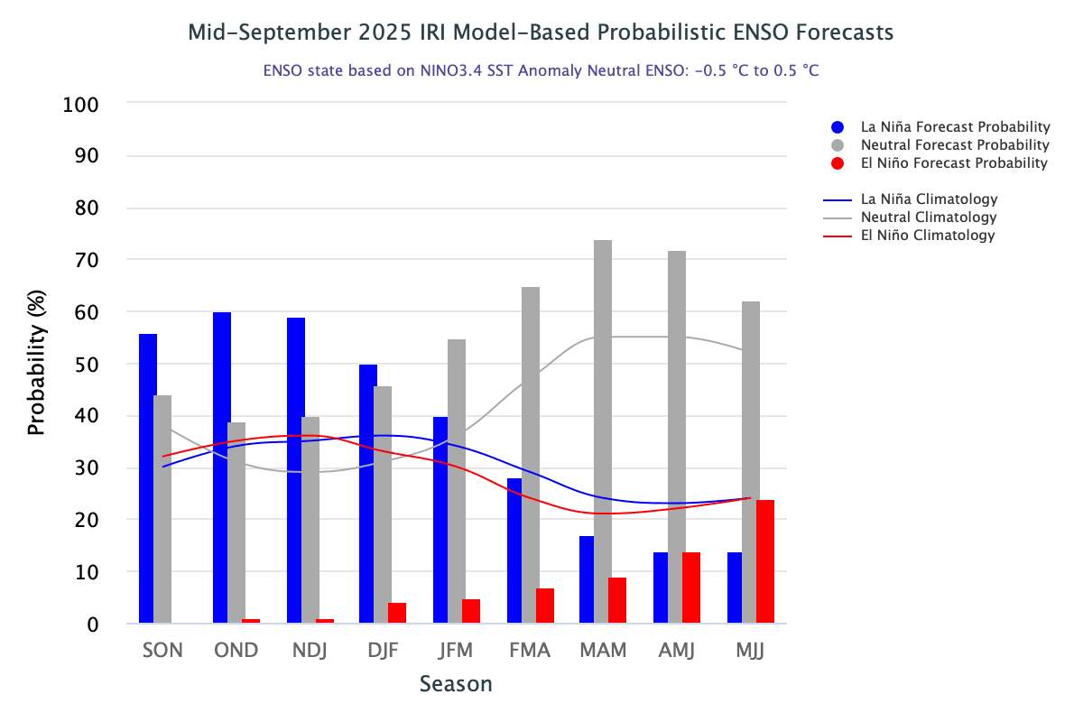
El Niño/Southern Oscillation variability is intimately linked to alternating stages of oceanic heat content build-up and discharge in the equatorial Pacific. In the last 25 years, since 2000, La Niña events have outnumbered El Niño occurrences. There were three long-duration La Niña events: MJJ 2007 – FMA 2009, MJJ 2010 – MAM 2012, and JAS 2020 – DJF 2023. Also, there have been truncated seasons of La Niña in 2024 (NDJ 24 – DJF 25) and another one is likely in 2025–26. It may commence from the quarter OND 25 and go on till DJF 26. Now, why the duration of La Niña has narrowed to the least margins, one after the other? Also, the start and end of events are defying the normal period of occurrence. Historically, El Niño/La Niña events tend to develop during the period Apr–Jun and they reach maximum strength during Oct–Feb. Typically, these events persist for 9–12 months and sometimes go beyond 24 months.
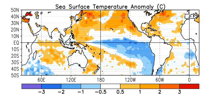
La Nina 2020
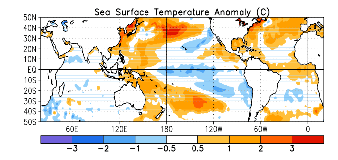
La Nina 2021
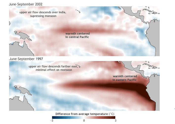
Importantly, not all El Niño/La Niña events are the same. The location of warming/cooling—not just the strength—in the Pacific keeps shifting pockets. During the El Niño events of 1997 and 2002, the location of warming shifted from central Pacific in 2002 to eastern Pacific in 1997. Even the La Niña pattern in 2020 and 2021 saw the cooler pockets changing stance and degree significantly. The El Niño/La Niña conditions are assessed, monitored, and predicted precisely based on the temperature profile in the Nino 3.4 region.
What has been learned since 2014 is that global warming is progressing with an unexpected and uncertain pattern: more warming in the Western Pacific and less in the eastern flank. Whether this is a temporary effect or a long-term discrepancy remains to be seen; but ultimately, the long-term warming due to greenhouse gas increases will dominate.
ENSO: As of September 2025, both atmosphere and ocean indicators continue to show ENSO-neutral conditions. Yet, there are pointers suggesting that the tropical Pacific may evolve towards weak La Niña conditions in the coming months. The SST anomaly in the Nino 3.4 region during the June–August 2025 season was -0.11°C. The current anomaly for the quarter July–September 2025 is -0.28°C. There is phenomenal cooling of the ocean surface in the Nino 3.4 region.
In September 2025, the Nino index breached the threshold mark of -0.5°C twice, on 15 September and 29 September. But the moot point remains as to why model projections indicate only a short stint of La Niña. What exactly are the factors restraining its continuation remains a contentious issue. Possibly, the subsurface temperature gradient between the Western Pacific and the Eastern Equatorial Pacific is leading to distortion of the temperature profile.
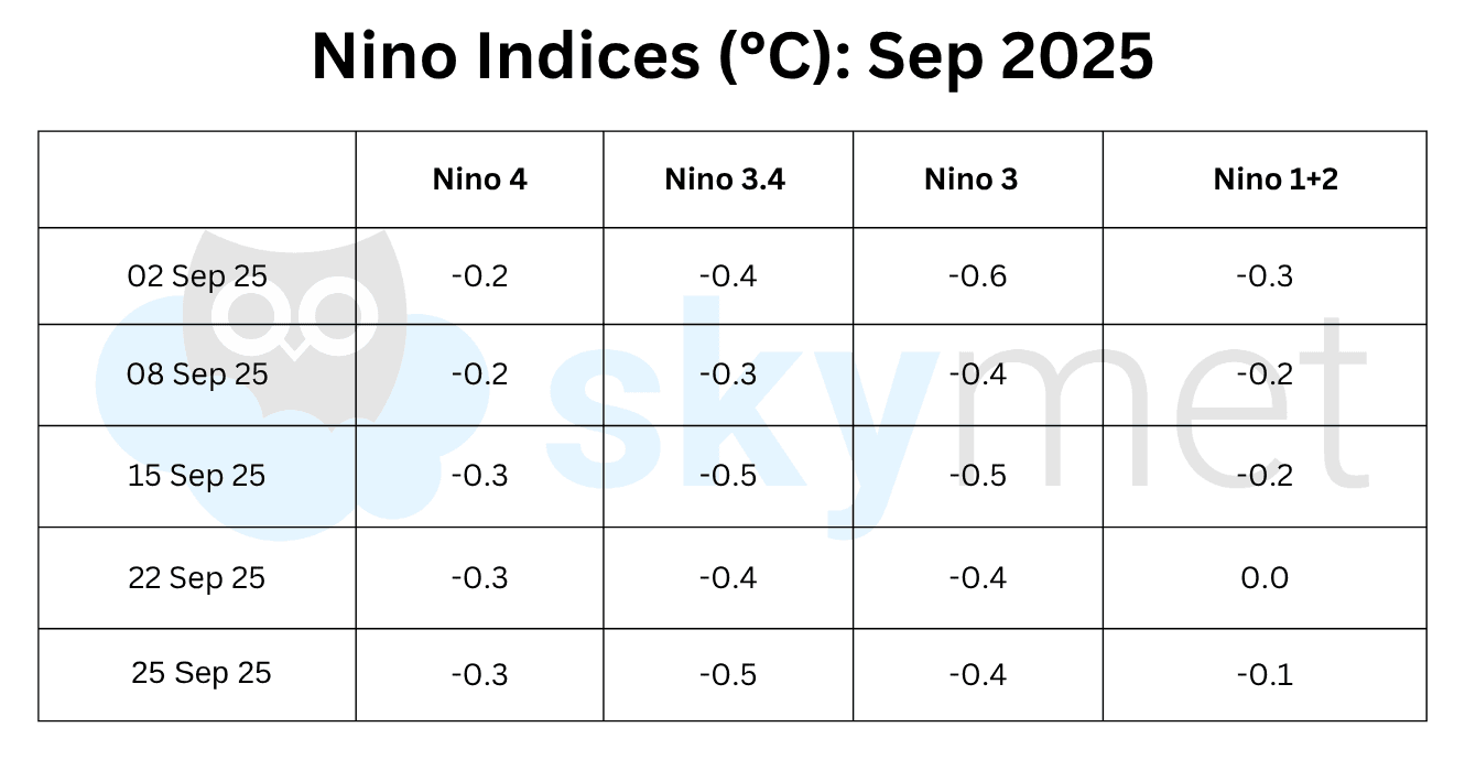
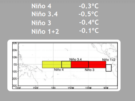
All four Nino indices have retained negative anomalies for the last six weeks. Out of these, the turbulent region, quite understandably, has been Nino 1+2. The proximity of the coastline and confinement of Nino 1+2 exclusively to the south of the equator is attributable to the significant fluctuations. The average Nino 3.4 anomaly for the month of September 2025 is -0.42°C and that is closer to the threshold mark than ever before in the season.
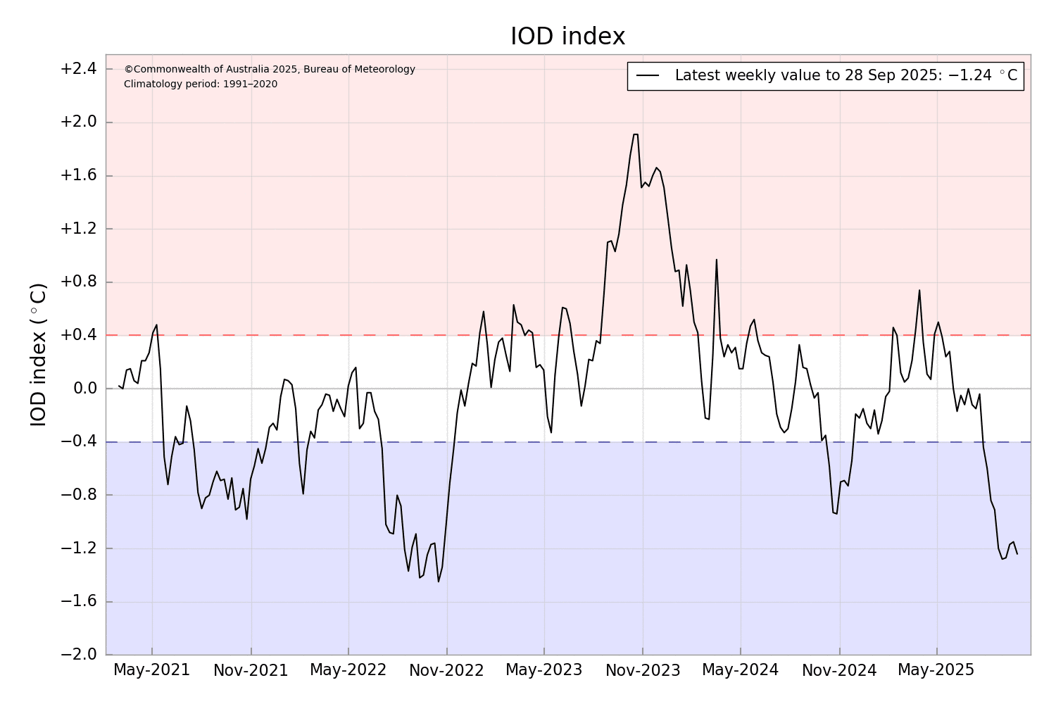
IOD: The negative phase of the IOD is underway. The latest IOD index for the week ending 28 September 2025 was -1.24°C. The average IOD index for the month of September 2025 is -1.22°C, which has far exceeded the threshold mark of -0.4°C. The model predicts the negative IOD event to continue through the autumn season and return to neutral during winter 2026. This is typical of the IOD cycle at this time of the year.
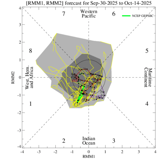
MJO: The Madden–Julian Oscillation pulse is progressing very slowly and with marginal amplitude. The MJO will remain over the Indian Ocean in Phase-2 for the next one week and later shift to the Western Hemisphere and Africa in Phase-1. The interaction of the MJO with emerging La Niña and developing negative IOD is likely to provide a continued favourable environment for tropical cyclones in the Western Pacific and the Indian Seas. There is a moderate risk of tropical cyclones forming over the Indian Seas during the first half of October 2025.
La Niña is in a nascent stage in the Pacific Ocean. Negative IOD is strengthening in the Indian Ocean. La Niña conditions by themselves do not augur well for the northeast monsoon over the South Peninsula. However, the rare combination of negative IOD and La Niña does not have a broad database for verifiable results. Preliminary estimates reveal that it may not be a bumper season for most sub-divisions of South India.