Likely El Nino May Push The Global Temperature To record High


Key Takeaways:
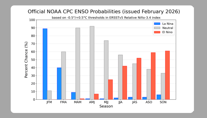
- Borderline La Niña conditions are likely to weaken and shift toward ENSO-neutral in early spring.
- Precursors of El Niño are emerging, but clarity on intensity and spread remains premature.
- IOD is expected to remain largely neutral through mid-2026, with slight positive bias.
- MJO activity is weakening and unlikely to significantly interfere with La Niña continuation.
According to the current forecasts from WMO Seasonal Prediction, oceanic and atmospheric indicators reveal borderline La Niña conditions. These are likely to dilute further and turn ENSO-neutral during early spring. Naturally occurring large-scale climate events such as La Niña and El Niño are taking place in the broader context of human-induced climate change, which is increasing global temperatures in the long term, exacerbating extreme weather and climate events, and impacting seasonal rainfall and temperature patterns.
The cycle of ocean temperatures in the Pacific, known as ENSO, is linked with adverse climate events in different parts of the globe. Prior to the occurrence of El Niño, a lot of warm water gets piled up in the western tropical Pacific. Favourable conditions toward El Niño reverse the trade winds, and the warm water sloshes back to the east, making the tropical equatorial Pacific hotter than normal in the Niño region. Precursors are present for an El Niño during the monsoon season, but it is too early to comment on the scale and spread of the phenomenon. The occurrence of El Niño has always pushed global temperatures higher. El Niño, which formed in mid-2023, persisted for 11 months and lasted until around April 2024. Water has a deep and strong memory, and it likely added 0.12°C to the global temperature in 2024. The past three years have each ranked among the top three warmest years on record for the planet. The year 2024 is the hottest on record, having surpassed 2023, with the global temperature reaching 1.55°C above the 1850–1900 pre-industrial level. Weather agencies and climate scientists have pointed to the possibility of an El Niño forming in the Pacific Ocean later this year—a phenomenon that could push global temperatures to all-time record highs in 2027.
ENSO: Oceans cover nearly 70% of the Earth’s surface. Therefore, observing and recording sea surface temperatures (SSTs) becomes essential to understand how the oceans communicate with the Earth’s atmosphere. SST is an indispensable parameter in weather prediction and atmospheric model simulations. SST data is the most critical indicator for identifying the onset of El Niño and La Niña cycles. Though the exact mechanism behind the rise and fall of temperatures during ENSO events is not fully understood, the commencement and cessation of these events can be forecast with a fair amount of confidence. When closer to the event, atmospheric models deliver exceptionally well.
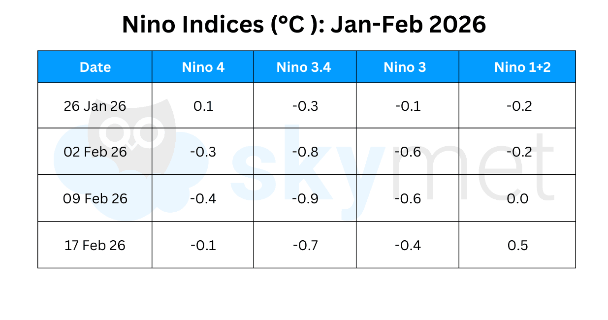
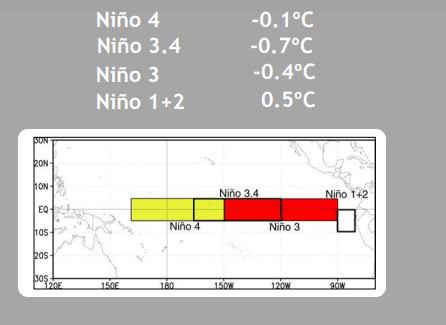
All Niño index anomalies indicate warming across the equatorial tropical Pacific Ocean. Niño 1+2 has reached the threshold mark of +0.5°C for the first time since August 2025. Niño 3.4, the marker index for ONI, has also warmed marginally but stays above the threshold La Niña mark of −0.5°C. The average anomaly for the last four weeks works out to −0.7°C, suggesting the continuation of La Niña conditions.
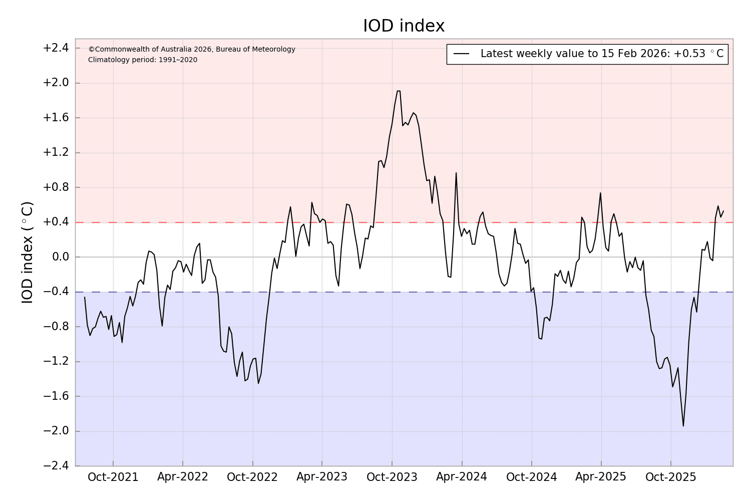
IOD: The Indian Ocean Dipole index is unlikely to show any spike during 2026. Throughout the February to July outlook, IOD-neutral conditions remain the most likely state. The probability distribution indicates a gradual increase in the positive IOD and a corresponding decrease in the negative IOD, while neutral conditions remain dominant across the forecast horizon. A positive IOD cycle remains more eventful globally. It triggers multiple cyclones over the East Africa region, and offshore warm waters activate the Southwest Indian Ocean cyclone season. Additionally, a positive IOD instigates Australian droughts and bushfires. A convective IOD cycle prevents moist air from moving south, concentrating it within the tropics.
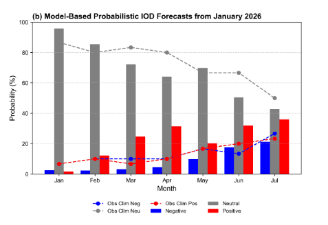
The IOD index has remained positive for the last four weeks, albeit close to the threshold mark of +0.4°C. The index value for the week ending 15 February 2026 was +0.53°C. The IOD forecast degrades after a lead time of 6–8 weeks, more so around the spring barrier window in the Northern Hemisphere.
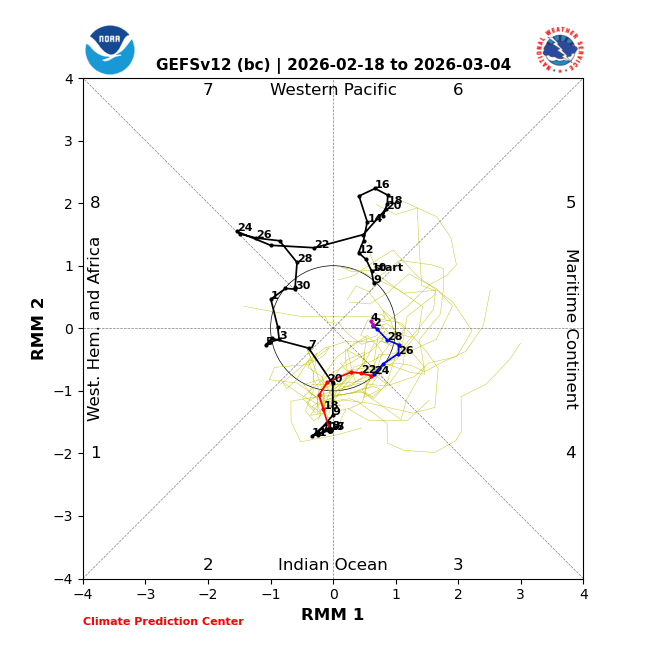
MJO: The Madden–Julian Oscillation pulse is likely to meander over the Indian Ocean in Phases 2 and 3 over the next two weeks. The amplitude will diminish and remain restricted to the inner circle for the remaining days of February and the start of March 2026. This suggests the pulse will not have any significant interaction with the La Niña conditions over the Pacific Ocean. The Indian seas will remain largely free from deep convection, which otherwise leads to transitory waves along the equatorial region.
True to the influence of the ‘spring barrier’, the Niño indices are fluctuating and remain difficult to interpret. The dilution of the MJO will avoid any adverse impact on the continuation of La Niña conditions. A positive IOD and weak La Niña together form a supportive combination for their respective persistence.
