Extremely Severe Cyclone Faniover west-central Bay of Bengal has now moved very close to the Indian Coast. It is presently centered near latitude 15.9°N and longitude 84.5°E, about 430 km south-southwest of Puri, Odisha, 210 km south-southeast of Vishakhapatnam, Andhra Pradesh and 630 km south-southwest of Digha, West Bengal.
Fani is all set to make landfall as extremely severe cyclone at Odisha coast near Satpada and Balukhand area in Puri district around afternoon of May 3.
Periphery of theExtremely Severe Cyclonic Storm Faniare already covering parts of Andhra Pradesh and Odisha. Raising an alert, heavy to veryrains with few extremely heavy rains would lash many parts of North Coastal Andhra Pradeshand adjoining areas of South Coastal Odisha on May 2. These rains would be accompanied with high velocity winds to the tune of 70-80 kmph gusting up to 100-120 kmph.
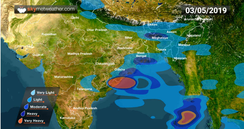
By Thursday night, as the system moves further north-northeast, rains would increase over Odisha. By May 3, rains would cover most parts of Odisha. Coastal areas would see extremely heavy rains at the time of landfall. Interior parts of Odisha would also see moderate to heavy rains.
By May 4,cyclonic storm Faniwould have moved to West Bengal and with this heavy rain belt would move to the state. By May 5, Fani as a weakened system would move to further North India but would still have power to give some heavy rains.
Checkout the rainfall alert and its intensity across Andhra Pradesh, Odisha, West Bengal, and Northeast India.
Image Credit:en.wikipedia.org
Any information taken from here should be credited to skymetweather.com