
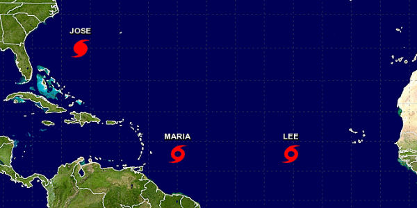
The latest forecast by the meteorologists for Hurricane Jose is that the storm continues to move along the East Coast, with its most anticipated impact on New England by the mid-week.
In the intervening time, two more systems have reached their tropical strength in the Atlantic. One of it is, Tropical Storm Lee that is situated about 650 miles west-southwest of Cape Verde in Africa, with winds gusting at a speed of 40 mph. This storm will be followed by another storm named as Maria on Saturday that could attain the potential of a hurricane as it approaches the Leeward Islands on Monday.
[yuzo_related]
The hurricane Jose was about 480 miles south-southeast of Cape Hatteras in North Carolina on Saturday moving northwest at 9 mph with sustained winds of 80 mph.
As of now, Jose is anticipated to stay offshore of the East Coast. Meteorologists expect its progress or movement to the west, triggering tropical storm conditions for North Carolina’s Outer Banks on Monday. This storm will affect from Virginia to New England in the coming days. Surges from the storm are likely to cause dangerous surf and rip currents for most of the East Coast.
It will be interesting to wait and watch what the other two tropical storms have in store for the areas that are likely to be affected.
IMAGE CREDIT: NOAA
