As of the start of 2024, El Nino conditions in the central-eastern Pacific remain strong with key oceanic and atmospheric variables consistent with an ongoing El Nino event. El Nino event is likely to weaken rapidly around spring 2024 in the Northern Hemisphere.
ENSO-neutral conditions become the most likely category in Apr-Jun 2024 and may evolve to La Nina later in the season. The positive IOD event is weakening steadily. The Southern Oscillation Index is getting diluted and may reverse sign, very soon.

ENSO: Devolving El Nino and evolving La Nina pattern seem to be dominantly emerging during the forecast period of Jan-Oct. In the far eastern Pacific, positive SST anomalies have been crashing. Over the central Pacific, the Nino indices remain strongly positive. Positive sub-surface temperature anomalies dominate most of the equatorial Pacific Ocean.
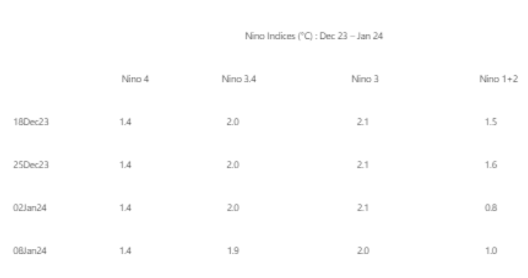
The western flank of the Nino region (Nino 4) is consistently warm with a positive anomaly of 1.4°C. Even the central region remains quite stable with a positive departure of around 2°C for the last about 7 weeks. The far eastern region of Nino 1+2 has been rather volatile and witnessing large fluctuations.
The Southern Oscillation Index has been dropping consistently and the mean monthly for Dec 2023 stands at -0.2, a sharp drop from its earlier value of -0.8 in Nov 2023. It is likely to turn zero-zero by the end of Jan 2024.

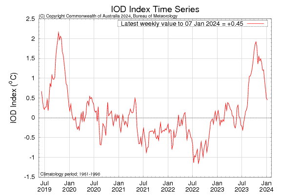
IOD: The positive Indian Ocean Dipole has been weakening. It has reached very close to the threshold mark. The IOD index is +0.45°C for the week ending 07 Jan 2024, compared to the value in excess of 1°C, a month ago. The breakdown has been later than normal this season. The models suggest the positive IOD is likely to continue to ease over the coming weeks and return neutral during January itself.

MJO: The Madden Julian Oscillation is currently over the Indian Ocean. In the current cycle, it has completed the circumnavigation of the equatorial belt in about 40 days. It is likely to move across the maritime continent, in Phases 4 & 5. Further, it is likely to propagate eastward over the Western Pacific during week 4. The amplitude also will increase as it shifts over the eastern parts of the Maritime Continent. This will favour an increase in rainfall activity over the Australian continent. After all, this is the time for the monsoon to ingress over Darwin ( Australia) and the neighbourhood.

IOD: The event is reaching its end soon and may recommence only in April, as it usually happens. El Nino will continue through the winters of the Northern Hemisphere and is unlikely to ease out till spring. The oceanic activities are literally in turmoil with SOI and IOD turning neutral. MJO will wax and wane in the equatorial belt over the next 4 weeks. El Nino holds its grip tight and is unlikely to erode, anytime soon.