

The current El Nino episode is one of the strongest on record. It falls in the ‘Super El Nino’ territory, wherein the Oceanic Nino Index (ONI) touched a record high of 2°C. From November 2023 to Jan 2024, the temperature of the tropical Pacific Ocean (Nino 3.4) was 2°C warmer than normal, according to NOAA’s Climate Prediction Center (CPC). The ONI for the current quarter of Dec-Jan-Feb is likely to be around 1.9°C. The threshold of 2°C has been breached only six times on record. Earlier, Super El Nino achieved this distinction in 1965, 1972, 1983, 1997, and 2015. And, an interesting fact, is that all these years were followed by La Nina, in the same year. The fastest changeover from El Nino to La Nina was in 1997-98. Intrinsically, the current episode will also follow the same track.

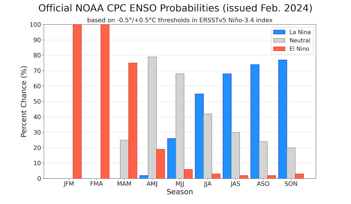
ENSO: El Nino seems to have past its peak and will head for the downward trend into the spring and turn ENSO neutral to greet monsoon 2024. El Nino advisory is presently in vogue, which means that El Nino conditions are observed and likely to continue. During the last 4 weeks, the above-average SSTs have slightly weakened across most of the equatorial Pacific Ocean. Subsea surface temperature anomalies became positive in Feb 2023. These anomalies too have weakened at depth, but persist in the upper 50-100 meters across most of the equatorial Pacific. It means, that a sudden collapse of Nino indices, more so the ONI, is not envisaged.

The Central Pacific Ocean is still warmer by 1.5 °C over the normal value. The flanks on either side, though relatively cool, remain fairly warm by over 1°C. Water is supposed to have a deep memory and does not lose the heat/cold hastily. A judicious estimate will carry the El Nino advisory for another 8 weeks or even more, before dropping below the threshold mark of 0.5°C.
IOD: The Indian Ocean Dipole has been weakening steadily over the last 4 weeks. It has returned to neutral and remained so for the third consecutive week. The weekly value of the index for the week ending 11 Feb 2024 was +0.17°C. It is quite likely to reach zero-zero in March 2024. In any case, the IOD value in the month of March/April remains inconsequential for any weather activity over the Indian seas. However, going by the historic record of IOD, the strong positive IOD in 2023 is unlikely to be replicated during the upcoming monsoon.

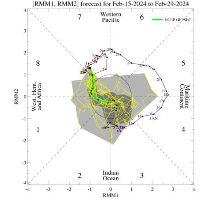
MJO: Madden-Julian Oscillation is in the process of transition from the West Pacific to Africa and the Indian Ocean, over the next 2 weeks ( Phase,8,1 & 2). Though there is no consensus, some members do suggest weakening of MJO, back into the RMM unit circle. Global seas, north of the equator are expected to remain benign during this period of forecast. However, an MJO meandering in Phase 7&8 favours increased chances of tropical cyclone development to the north of Australia and the Gulf of Carpentaria.
The tropical Pacific atmosphere anomalies are consistent with El Nino. The atmospheric component of ENSO has withdrawn support, as the index has turned positive. The IOD remains neutral, albeit inconsequential to the health of El Nino. The final advisory of El Nino is expected no earlier than Apr-May 2024.

