
Updated on May 18, 2020 5:30 PM IST: Extremely Severe Cyclone Amphan intensifies to Super Cyclonic Storm
The Super Cyclone Amphan is moving over west-central and adjoining central parts of the South Bay of Bengal near latitude 13.7°N and longitude 86.2 °E. Super Cyclonic Storm Amphan is about 730 km nearly south of Paradip (Odisha), 890 km south-southwest of Digha (West Bengal) and 1010 km south-southwest of Khepupara (Bangladesh). It is very likely to move nearly northwards for some more time and then north-northeastwards across the northwest Bay of Bengal and cross West Bengal – Bangladesh coasts between Digha (West Bengal) and Hatiya Islands (Bangladesh) during the Afternoon / Evening of 20th May 2020 as an Extremely Severe Cyclonic Storm with maximum sustained wind speed of 165-175 kmph gusting to 185 kmph.
Updated on May 18, 2020 9:35 AM IST:
Very Severe Cyclonic Storm Amphan has rapidly intensified into an Extremely Severe Cyclonic Storm and is centered over central and adjoining South Bay of Bengal, around 13Nand 86E. The cyclone is moving north and intensifying further. Clearly marked EYE with dimensions of about 20km diameter is proving it might. The cyclone will remain in the open and deep waters of Bay of Bengal under favorable environmental conditions.
Updated on May 18, 2020 8:00 AM IST:
Very Severe Cyclonic Storm, Amphan is over the central Bay of Bengal and is centered around 13N and 86.2E, about 800km south of Paradip and 950km SSW of Digha. The storm has moved nearly northward in the last 12 hours with a speed of about 12kmph. Cyclone Amphan is likely to move NNE now and also intensify into an Extremely Severe Cyclonic Storm in the next about six hours. The storm has developed a very compact and clearly marked EYE, as a mark of its strength. The storm is packed with winds of 150kmph and gusting to 170kmph. The cyclone is likely to cross the West Bengal-Bangladesh border between Digha and Hatia on 20th May.
Updated on May 17, 2020 6:00 PM IST:
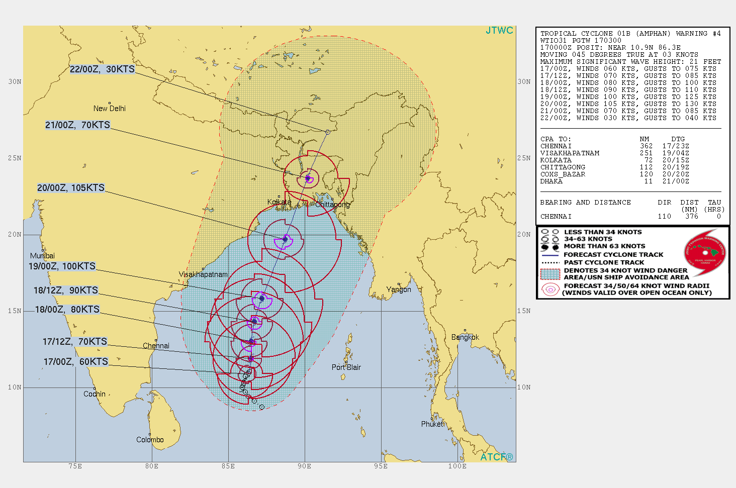
Cyclone Amphan has rapidly intensified into a Very Severe Cyclonic Storm (VSCS). The storm is now centered around 11.6N and 86E, about 950 km south of Paradip and1250 km SSW of Kolkata. It will be moving nearly north for some time and then recurve to move northeast. Likely to intensify further to Extremely Severe Cyclonic Storm (ESCS) in the next 24hr. The cyclone is likely to make landfall on 20th May, in the bordering area of West Bengal and Bangladesh.
Updated on May 17, 2020 12:30 PM IST: Cyclone Amphan intensified to severe cyclonic storm
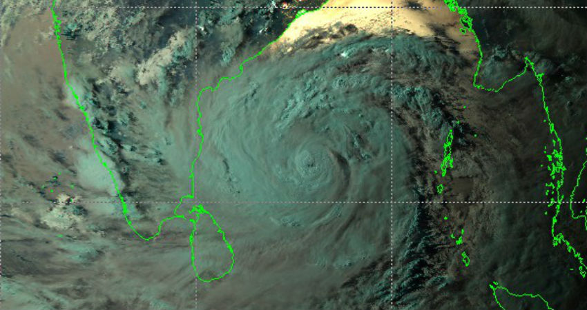
Cyclone Amphan has strengthened to a Severe Cyclonic Storm centered around 11.2N and 86E, about 1250km SSW (southsouthwest) of Kolkata. The storm is packed with winds of 110 kmph and gusting to 140 kmph. It is likely to develop further to Very Severe Cyclonic Storm by the evening and with ongoing intensification to reach CAT-III hurricane strength over the next 48hr. It is very likely to feature an 'eye', a show of strength of the cyclone, in another 24 hours.
Cyclone Amphan is having typical signs of cloud configuration with intense feeder bands, dense overcast circular cloud, and strong poleward outflow. The environment is strongly supporting further development. The storm is now moving northward and will shortly steer NNE (northnortheast) and upgrade to ESCS (extremely severe cyclonic storm) by May 19th morning, while over the central Bay of Bengal. Cyclone Amphan will retain this strength for over 24 hours and move up to the north Bay of Bengal.

It is likely to make landfall on May 20th morning in the bordering area of West Bengal and Bangladesh.
Extremely rough sea conditions are expected for the next 04 days with wave height more than 20feet. High-velocity winds and extremely heavy downpour with catastrophic damaging potential is expected from 18th-20th May. Landfall amid Covid-19 and 'lockdown' is going to add another dimension to the level of preparation, including for evacuation. 'Red Alert' is sounded for 03 days (18-20 May) to go into the absolute secure mode and utmost precautions.
