

Updated on May 18, 2020 5:30 PM IST: Extremely Severe Cyclone Amphan intensifies to Super Cyclonic Storm
The Super Cyclone Amphan is moving over west-central and adjoining central parts of the South Bay of Bengal near latitude 13.7°N and longitude 86.2 °E. Super Cyclonic Storm Amphan is about 730 km nearly south of Paradip (Odisha), 890 km south-southwest of Digha (West Bengal) and 1010 km south-southwest of Khepupara (Bangladesh). It is very likely to move nearly northwards for some more time and then north-northeastwards across the northwest Bay of Bengal and cross West Bengal – Bangladesh coasts between Digha (West Bengal) and Hatiya Islands (Bangladesh) during the Afternoon / Evening of 20th May 2020 as an Extremely Severe Cyclonic Storm with maximum sustained wind speed of 165-175 kmph gusting to 185 kmph.
Updated on May 18, 2020 9:30 AM IST:
Very Severe Cyclonic Storm Amphan has rapidly intensified into an Extremely Severe Cyclonic Storm and is centered over central and adjoining South Bay of Bengal, around 13Nand 86E. The cyclone is moving north and intensifying further. Clearly marked EYE with dimensions of about 20km diameter is proving it might. The cyclone will remain in the open and deep waters of Bay of Bengal under favorable environmental conditions.
Updated on May 18, 2020 8:00 AM IST:
Very Severe Cyclonic Storm, Amphan is over the central Bay of Bengal and is centered around 13N and 86.2E, about 800km south of Paradip and 950km SSW of Digha. The storm has moved nearly northward in the last 12 hours with a speed of about 12kmph. Cyclone Amphan is likely to move NNE now and also intensify into an Extremely Severe Cyclonic Storm in the next about six hours. The storm has developed a very compact and clearly marked EYE, as a mark of its strength. The storm is packed with winds of 150kmph and gusting to 170kmph. The cyclone is likely to cross the West Bengal-Bangladesh border between Digha and Hatia on 20th May.
Updated on May 17, 2020 6:00 PM IST:
Cyclone Amphan has rapidly intensified into a Very Severe Cyclonic Storm (VSCS). The storm is now centered around 11.6N and 86E, about 950 km south of Paradip and1250 km SSW of Kolkata. It will be moving nearly north for some time and then recurve to move northeast. Likely to intensify further to Extremely Severe Cyclonic Storm (ESCS) in the next 24hr. The cyclone is likely to make landfall on 20th May, in the bordering area of West Bengal and Bangladesh.
Updated on May 17, 2020 12:30 PM IST: Cyclone Amphan intensified to severe cyclonic storm
Cyclone Amphan has intensified to a severe cyclonic storm over the west central Bay of Bengal. It has moved slowly northwest in the past 12 hours and is centered about 1250 km SSW (southsouthwest) of Kolkata and 950km south of Paradip. The storm will start moving northward initially and then NNE (northnortheast). Likely to become Very Severe Cyclonic Storm (VSCS) by today evening and Extremely Severe Cyclonic Storm(ESCS) in the subsequent 24 hours. It is likely to make landfall on the 20th May morning, close to West Bengal - Bangladesh border. Adverse weather conditions with high velocity winds more than 120 kmph and extremely heavy rains are likely along and off Odisha-West Bengal coast between 18th and 20th May. Red Alert is sounded for the two states to observe utmost safety and precautions.
Updated on May 16, 2020 6:00 PM IST: Depression in Bay of Bengal intensified to Deep Depression
The deep depression in the Bay of Bengal has intensified into a cyclonic storm. The maiden cyclone, cyclone Amphan, of this season is centered around 10.5N and 86.4E, about 650km ESE (East South East) of Chennai. The system remains in favorable environmental conditions and will shortly intensify further to a severe cyclonic storm.
Landfall is expected on May 19th late night or 20th morning, Southeast of Kolkata, subject to revision. The storm will have catastrophic damaging potential with extremely heavy rains and high-velocity winds, along with and off the coast of Odisha and West Bengal.
Updated on May 16, 2020 11:30 AM IST: Depression in Bay of Bengal intensified to Deep Depression
The depression in the Bay of Bengal has intensified to a deep depression, centered around 10.5N and 86.8E. The system continues to be in favorable environment and is likely to burgeon to a significant cyclone in the next few hours, earlier than expected. The deep depression is presently located about 850km SSE of Visakhapatnam and 1100 km south of Paradip, Odisha. The system will move northwest and reach abeam Chennai, keeping a safe distance of about 600km by this evening, as a developed cyclonic storm. Thereafter, it is likely to move northward and intensify to a severe cyclonic storm in the subsequent 24 hours.
Updated on May 15, 2020 1:30 PM IST:
The well marked low pressure area southeast Bay of Bengal has intensified into a depression. The system is centered around 10.6N and 87.3E, about 900km southeast of Visakhapatnam. The depression is moving northwest and remains in a favorable environment for further development. It is likely to become a cyclonic storm by tomorrow and reach abeam Chennai at a safe distance of approximately 600km. The storm thereafter will be moving initially north and then northnortheast (NNE) and strengthen further to a severe cyclonic storm. Extreme northern parts of coastal Odisha and West Bengal will run the risk of direct impact around 19th May.
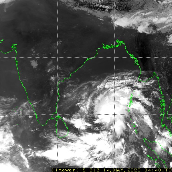
Updated on May 14, 2020 2:00 PM IST:
The developments are quick and fast in the Bay of Bengal. The low pressure area over the southeast Bay of Bengal appears to be well marked. The area of convection is centered around 9.2N and 87.1E, approximately 1000km southeast of Visakhapatnam. The cloud cluster is supported by weak spiral banding around the circulation. It is likely to consolidate and the potential to develop to a significant cyclone in the next 48hrs is high.
The low pressure area is likely to intensify to depression in the next 24 hours and further to a cyclonic storm in the subsequent 24 hours. The system will be initially moving northwestward and come abeam Chennai, at a distance of nearly 600km by 16th May. Hereafter it is likely to shift track and move nearly northward. The numerical weather models diversity about the timelines, track, and intensity continues and a confident forecast is feasible only after another 24 hours.
Indian coastline from Andhra Pradesh to West Bengal across Odisha remains vulnerable. The lead environmental conditions like sea surface temperature, vertical wind shear, and positioning of MJO are supportive of further intensification to a severe cyclonic storm and possibly a very severe cyclonic storm. Initial indicators point towards a landfall, tentatively around 18-19 May but with low confidence. The recurving route of the storm is resulting in iffy conditions as the speed factor during this phase goes awry.
Considering large variations in the weather models about the cyclogenesis, the complete region is under close watch for the next 48 hours.The available time is advised to be utilized for the consolidation of resources and tactical preparations.
