

Steady El Nino decline is perceptible over the last few weeks. However, there is no sharp drop to suggest a collapse of the event, early in the season. Madden- Madden-Julian oscillation in the Pacific region is interacting mischievously with the atmospheric indicators to cause fluctuations in the El Nino state. Decay of El Nino event is imminent but how soon, is the question. Sea Surface Temperatures in the central tropical Pacific and temperatures in the Pacific sub-surface are supportive of cooling, in line with the degradation of events. El Nino's breakdown is very evident and so is the announcement of La Nina ‘Watch’.
The decay of El Nino and the potential development of La Nina increases the probability of normal or above normal southwest monsoon. Notwithstanding, the other parameters need to be factored in, for their respective role and influence. Broadly, expectations are rising for the monsoon 2024 to be healthier than average.
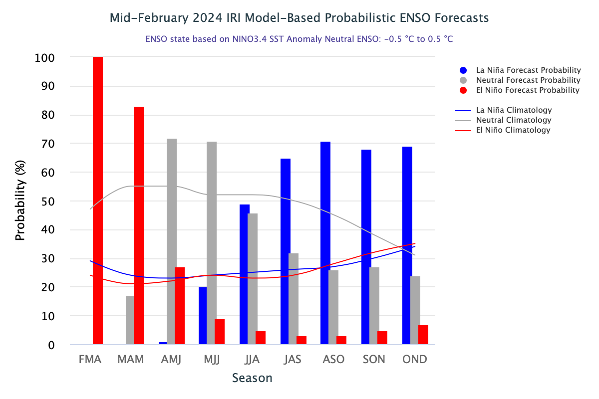
ENSO: El Nino and La Nina events tend to develop during the period Apr-Jun and last for 9-12 months. Invariably, they reach their maximum strength during Oct-Dec, the fall of the year and wind up in the early spring. When El Nino does not follow an exact cyclical timeline, they tend to peak during the winters of the Northern Hemisphere and decay by early summers, as is the pattern with the ongoing event. NOOA says, that the El Nino has shown first signs of weakening. Sea surface temperature anomalies are starting to lower, albeit incrementally. The abnormally strong westerly trade winds during El Nino have started slowing down. Reversal may happen soon.

The current El Nino peaked with the highest ONI of 2.0, the least required to qualify for the Super El Nino event. Among the Nino indices, the most important and biggest region Nino 3.4, covers half of the equatorial Pacific Ocean. All the Nino indices have dipped marginally, this week. Nino 3.4 and Nino 3 have measured anomaly of 1.5°C, whereas, in the flanks, Nino 4 and Nino 1+2 have dropped to a low of 1.1°C.
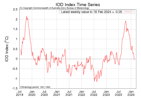
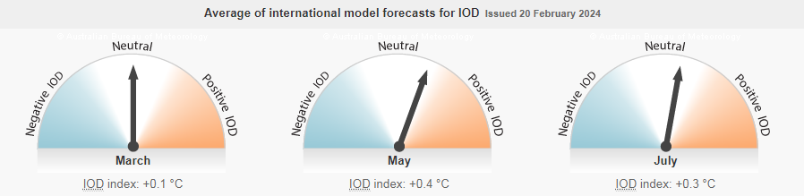
IOD: The Indian Ocean Dipole has crashed to become negative neutral. The index value for the week ending 18th Feb 2024 was -0.05°C. The IOD is likely to remain neutral until, at least April, consistent with the annual cycle of IOD. Most numerical models like BoM, ECMWF, and UKMO indicate IOD to remain neutral, till July 2024. It means that IOD may not outrightly support Monsoon 2024. But, it will not have any adverse effect, either. The graph of the previous year is rarely repeated in the succeeding season and therefore, the IOD may just hold neutral status throughout the monsoon season.
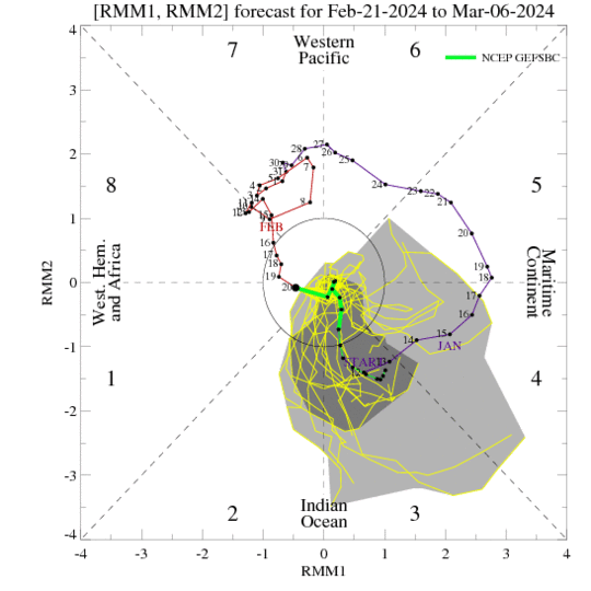
MJO: The Madden-Julian Oscillation has propagated eastward and entered the Western Hemisphere (Phase-8) as a borderline case. The MJO is likely to weaken significantly. The amplitude will remain confined to the inner circle and the pulse will remain weak, till the start of March 2024. Some models are suggesting the strengthening of MJO over the Maritime Continent in Phases 4 & 5, during the first week of March 2024. Unlike last week, wherein two tropical cyclones developed in the South Pacific and the South Indian Ocean remained benign, conditions may be different this week. As per JTWC, there are higher chances of a tropical cyclone development, over the South Indian Ocean, east of Madagascar.
An increased number of climate models are promising the likelihood of La Nina during Jul-Sep 2024. However, predictability during this time is hampered by the ‘spring barrier’. Therefore, consistent model validation and elimination of progressive error, if any, need to be subjected before any conclusive inference is drawn.
