El Nino has not opened the cards lucidly and keeps the suspense floating. Warm oceans have long memory and have the potential of moderating climatic conditions. Incoherence may linger on for little longer than expected. Super El Nino has historically taken about 6 months to dissolve after reaching the peak. If, so be the case, broad estimates suggest the event to turn neutral by May 2024.

ENSO: The sea surface temperature (SST) anomaly for Nino 3.4 region during Dec-Feb season was at 1.77°C and for the month of February 2024, it was + 1.53°C. The most recent weekly anomaly as on 18 March 2024 was +1.10°C. It perspicuously indicate that tropical Pacific is experiencing a gradual decline of El Nino conditions. Earlier, there were few aberrations as well, wherein the index had marginally risen, albeit for a very brief period.

Fluctuations in the indices, this week, seems to be large. The flanks have become rather cooler and more so, Nino 1+2 region. This index has dropped below the threshold of 0.5°C, for the first time since Jan 2023. Earlier, this was the hottest bed during last monsoon, when the index breached 3°C, for fairly long in July and Aug 2023. As of now, Nino 3.4 is the warmest and therefore, suggest slow recession of ONI.
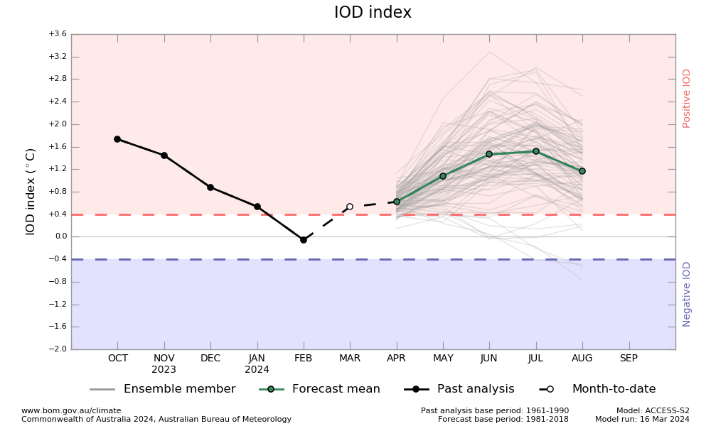
IOD: There was an unexpected spike in the Indian Ocean Dipole. The most recent value of the IOD index was +0.86°C for the week ending 17 March 2024. This has breached the positive threshold of +0.4°C after 8 weeks. It has taken a big leap from the last week’s neutral stance of +0.24°C, on 10Mar 2024. It is unlikely to sustain the steep rise and may even get diluted in the subsequent weeks.

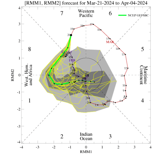
MJO: The Madden-Julian Oscillation is strong and currently located over the Western Pacific. It is likely to progress eastward over Western Hemisphere and weaken at the start of next month. Historically, MJO over Western Pacific at this point of time enhances the active phase of Australian monsoon. Oceans are lying dormant over the Northern Hemisphere. The Southern Hemisphere has a single storm, Neville, a category IV equivalent, far to the west of Australian coast. It is likely to move further away over the open waters and weaken.
Statistical correlation of Super El Nino followed by strong La Nina, has historically improved the monsoon prospects. But then, El Nino/La Nina are not the only players steering monsoon. Other oceanic and glacial contents need to be factored for comprehensive read of monsoon.