
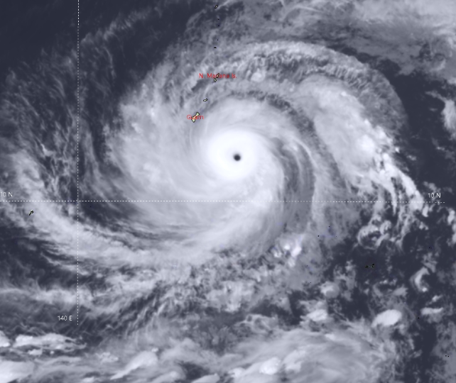
Tropical storm ‘MAWAR’ has intensified to become a super typhoon over the Philippines Sea. The typhoon is centred around 15.1°N and 139.3°E, about 600 km west-northwest of Anderson Air Force Base, Guam. The super typhoon is speeding away at the rate of 25kmh, mercifully over the open waters. The storm is packed with winds gusting above 300kmh and throwing waves in excess of 65 feet high. Though the storm has catastrophic potential, will sail over the ocean without encountering any landmass for the next 48 hours, retaining the status of a Cat-5 hurricane. A wind speed of >/= 252kmh is graded as a super typhoon or Cat-5 hurricane.
Satellite imagery depicts Mawar as a large symmetrical system. The CDO(cloud-dense overcast) is beautifully manifesting a sharp outlined ‘eye’ with a 40km diameter. Typhoon is travelling under the favourable environment of the very warm sea surface, low vertical wind shear and strong radial flow aloft. The super typhoon will move west-northwest for 48 hours and subsequently, passage over relatively cooler waters and increased vertical wind shear will downgrade it to a Cat-2 hurricane, well short of the Philippine coast. It is likely to recurve and skip direct strikes over the Philippines and Taiwan. The typhoon will head for the Sea of Japan, ravaging Japanese Islands en route.

Though sailing over the ocean far away from the Indian region, these powerful storms have the potential to unsettle the wind pattern over the Bay of Bengal (BoB). Once disrupted, streamlining the normal flow takes a few days time. The chain of islands over BoB are witnessing the ‘drying’ effect for the last few days. Northern islands have not seen any rain for the last 4-5 days. Their monthly rainfall of about 400-500mm remains far short of the target and struggles to reach 3 digit mark. The storm is expected to vacate the Philippines Sea by 28th May. After recurvature, it is likely to speed up and clear ground to resume normal, starting with the equatorial region of south BoB.

Such storms impact the wind pattern over hundreds of kilometers which invariably depletes moisture over India. Monsoon in India largely depends on low-level moisture transport from the Indian Ocean towards the Indian landmass. The sapping of moisture, in turn, weakens the monsoon stream.
