Updated on March 16, 2018 11:00 AM (IST): System in Arabian Sea weakens into Low Pressure Area, to decay soon
The well-marked low-pressure area which was persisting over Lakshadweep and adjoining Southeast Arabian Sea has now weakened into a low-pressure area and can now be seen over Lakshadweep and adjoining Southeast Arabian Sea off the Kerala-Karnataka coast.
The system is now expected to weaken further dissipating in the sea itself. However, during the next 24 hours, the peripherals of the system.
[yuzo_related]
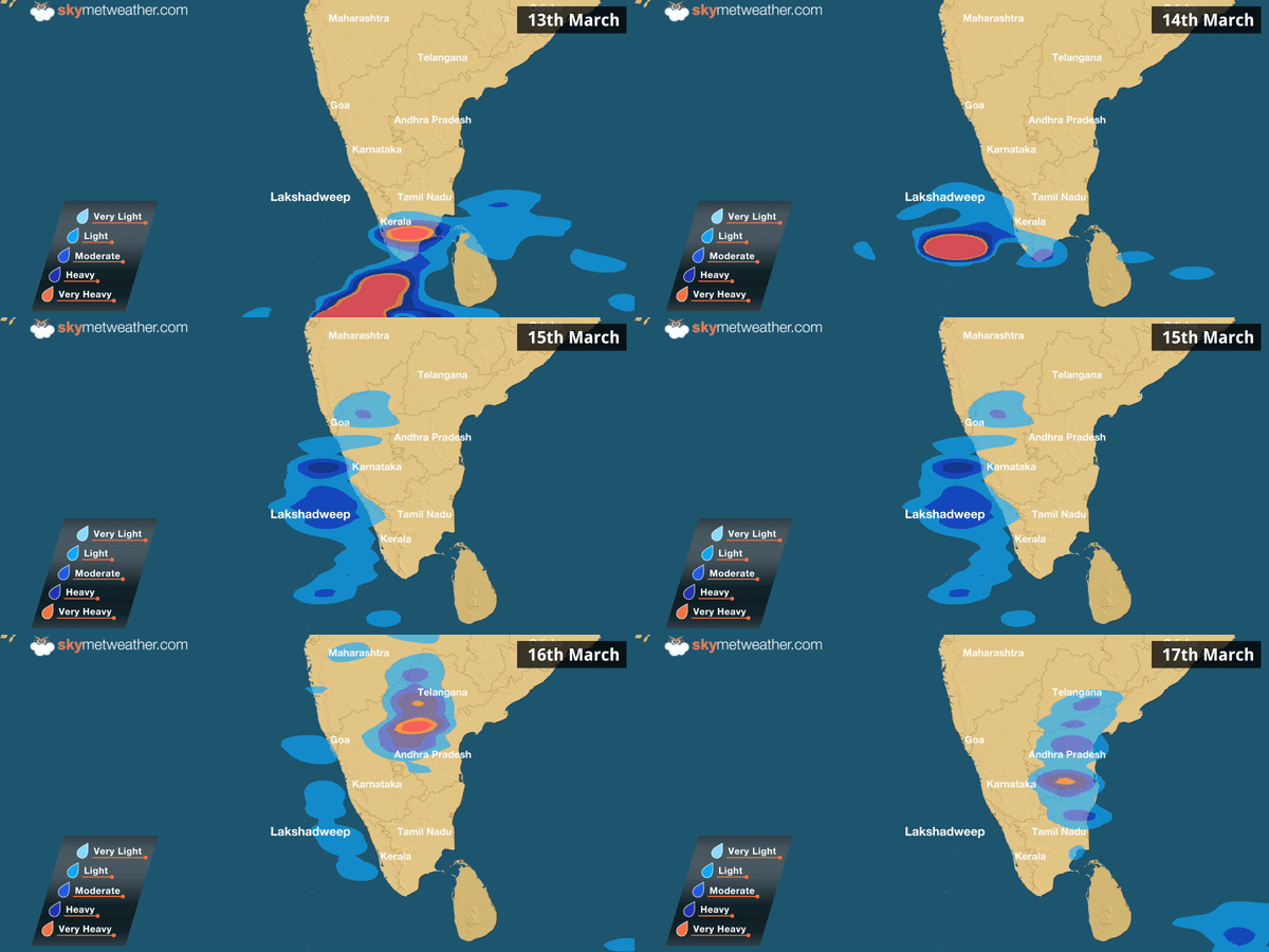
Now, while the system has weakened, the remnants of the system and the peripheral clouding will still result in some rains over the Lakshadweep Islands, Kerala and Karnataka Coast. Moreover, parts of coastal Maharashtra will also see some rains during this period.
Thereafter, as the system fizzled out further, weather will clear up over all these areas.
Updated on March 15, 2018 11:25 AM (IST): Depression in Arabian Sea weakens into Well Marked Low Pressure, to dissipate soon
As predicted, the depression over Southeast Arabian Sea has weakened into a well marked low pressure area and is now seen over Lakshadweep Islands and adjoining Southeast Arabian Sea.
It has been moving northnorthwestwards and would continue to move in the similar direction. However, as the system is now travelling in the unfavourable weather conditions, we expect well-marked low pressure area to weaken gradually over Southeast and adjoining East-Central Arabian Sea during next 24 hours.
[yuzo_related]
According to Skymet Weather, the weather system has now moved into cooler waters where sea surface temperatures (SSTs) are declining sharply. For the intensification of the system, SSTs should be above 26°C. But, since it is still travelling open waters, it may only be able to sustain its strength for some more time. However, any further intensification is completely ruled out.
The intense clouding has been limited to the sea and only peripherals of the system are reaching the coast. Therefore, there has not been any intense rains along the West Coast but moderate showers were seen over several parts under its influence.
Now as the system weakens further, clouding will also spread out. Thus, light to moderate rains are likely over Coastal Karnataka and Konkan & Goa region during the next 24 hours. In this process, Mumbai could also record light rains.
Updated on March 14, 2018 09:25 AM (IST): Depression in Arabian Sea to persist; heavy rain in Lakshadweep, Kerala, Tamil Nadu
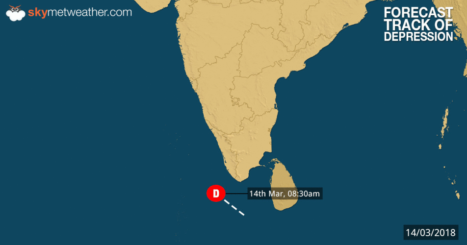
The persisting depression which was over Southeast Arabian Sera has now moved in a northwest direction at 8 kmph during the last six hours. At 05:30 am IST, the system was over Southeast Arabian Sea near Latitude 7.0°N and Longitude 74.5°E about 200 km SE of Minicoy In Lakshadweep, 310 km SW of Thiruvananthapuram and 330 km NNE of Male in Maldives.
The system is now expected to move in a north-northwest direction. As per weathermen, the system is not expected to further intensify into a deep depression and will maintain its depression status for the next 24 hours.
The system will then gradually weaken moving towards Southeast and adjoining East-central Arabian Sea. Due to this, heavy rainfall activity is expected over some parts of Lakshadweep as well as Kerala region for the next 24 to 36 hours. Along with this, good rainfall activity is also expected to occur over parts of Tamil Nadu and Puducherry.
Scattered rains are also likely over some parts of Karnataka during this period. Squally winds of about 40-50 kmph gusting up to 60 kmph are likely over Comorin region along with South Tamil Nadu and Kerala coast. Sea conditions are also expected to remain rough over Comorin and Maldives region along with the Southeast Arabian Sea.
Updated on March 13, 2018 1:30 PM (IST) : Depression forms in Arabian Sea, may intensify into deep depression in 48 hours
Intensifying further, the well marked low pressure area over Equatorial Indian Ocean and adjoining Southwest Sri Lanka and Maldives-Comorin area has now concentrated into a depression over Southeast Arabian sea and adjoining Equatorial Indian Ocean.
It is presently centered at latitude 5°N and longitude 76°E, around 485 km southeast of Minicoy, 395 km southsouthwest of Thiruvananthapuram and 290 km eastnortheast of Male in Maldives.
According to Skymet Weather, the depression would now move in northwest direction parallel to the West Coast but far away from the coast. As the system is moving in open waters, it seems that the system might intensify further into a Deep Depression during the next 48 hours. However, we need to wait and watch for this.
 Updated on March 13, 2018 12:30 PM (IST) : Well-marked low in Bay gets more marked, depression likely in 24 hrs
The well-marked low pressure area over Equatorial Indian Ocean and adjoining South Sri Lanka and Maldives-Comorin Area continues to sustain its strength. The system is now seen over Equatorial Indian Ocean and adjoining Southwest Sri Lanka and Maldives Comorin Area.
[yuzo_related]
As the weather models suggest, it would continue to move in westnorthwest direction and thereafter northwestwards. With the system still moving in open waters, the well-marked low pressure area would intensify into a depression over Southeast Arabian Sea (Maldives area) during the next 24 hours. However, it may not gain any further strength but nothing cannot be ruled as the system would continue to move in favourable weather conditions of open waters.
Under the influence of the system, moderate to heavy rains are likely to lash southern parts of Kerala and Tamil Nadu during the next 24 hours. Sea conditions would also remain rough to very rough off and along the coast. Thus, fishermen and locals are advised to ventured out in the sea.
Places in Kerala and Tamil Nadu such as Thiruvananthapuram, Kochi, Alappuzha, Thrissur, Kanyakumari, Tuticorin, Palayamkottai, Punalur, Madurai and Tondi would see some good spell of pre-Monsoon rains. Meanwhile, rest of the areas of both the neighbouring states might see light to moderate showers.
Updated on March 12, 2018 12:00 PM (IST) :Pre Monsoon season begins with a bang as well-marked low forms in Bay, depression likely:
As predicted, the low-pressure area in Comorin region has now intensified into a well-marked low pressure area. It is presently seen over Equatorial Indian Ocean and adjoining Comorin area, south Sri Lanka and Southwest Bay of Bengal.
According to Skymet Weather, the system would move in west-northwest direction towards Southeast Arabian Sea. As the system continues to move in favorable conditions, it is most likely to concentrate into a depression during the next 48 hours over Southeast Arabian Sea.
Following is the expected track of the weather system brewing in Indian Ocean over the next couple of days.
However, its further intensification is very unlikely. According to weathermen at Skymet Weather, usually we do not see many systems forming in Equatorial Indian Ocean due to dynamical reasons. Even if they form, they are not able to intensify beyond depression. They generally move in west-northwest direction.
Under the influence of the system, we can expect squally winds with the speed of 40-50 kmph gusting up to 60 kmph over Comorin area off Coastal South Tamil Nadu and South Kerala and over Southeast Arabian Sea during the next 48 hours and subsequently over Lakshadweep Islands in the next 72 hours. Sea conditions would also remain rough off and along the coast.
As per the meteorologists, after reaching Arabian Sea, it would then most likely travel in northwest direction. It would move parallel to the West Coast, but slight away from it.
The system would largely affect Comorin region and Sri Lanka, that could see come moderate to heavy showers in the coming days. But the peripherals of the system would be capable enough of giving good rains over parts of South and Interior Tamil Nadu, Kerala, Karnataka and even covering parts of Konkan & Goa region.
Major cities of Bengaluru, Chennai, Kochi, Mumbai and Hyderabad all stand good chances of witnessing first spell of pre-Monsoon rain and thundershowers of varying intensity.
Any information taken from here should be credited to skymetweather.com


