
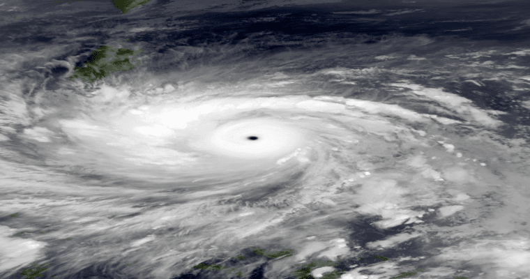
The West Pacific Ocean becomes an active basin for tropical storms around this time. Though the stormy season runs throughout the year most tropical cyclones develop between May and October. Most intense and frequent typhoons form during September-October over the Philippines Sea and South China Sea. Last year, 2 tropical storms, Megi and Malakas, formed over West Pacific in April itself.
Madden Jullian Oscillation has been active since April 2023. While propagating eastward across the Maritime Continent and West Pacific, it triggered cyclonic disturbances. Super cyclone 'Mocha' developed over the Bay of Bengal and struck Myanmar-Bangladesh on 14th May 2023. There is another tropical cyclone Fabian, a category-3 equivalent hurricane in the South-Central Indian Ocean. The storm is still sailing over the open sea, south of the equator, abeam Indian longitudes of the South Peninsula.
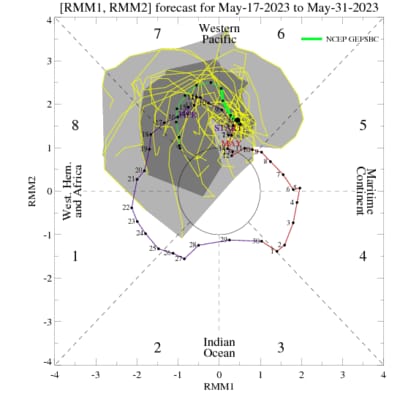
Low-level westerly winds have been firmly entrenched over the Western Pacific and are unlikely to change. MJO is traversing across the Western Pacific slowly and is likely to remain in that region till the month's end. There is good agreement amongst a range of numerical models and the ensemble is bullish about cyclone development around the last week of May. The deepening of the low-pressure belt is likely over the Philippines Sea, later turning into a tropical storm. There is a bit of uncertainty about the timings, as of now. However, the last week of May remains the most favoured window with over 50% chance.
The formation of tropical cyclones may coincide with the normal dates of arrival of Monsoon over the mainland. Such storms impact the wind pattern over hundreds of kilometres which invariably depletes moisture over India. Monsoon in India largely depends on low-level moisture transport from the Indian Ocean towards the Indian landmass. The sapping of moisture can, in turn, weaken the monsoon stream. Cyclogenesis over the Northwest and West-Central Pacific Ocean is stronger and more frequent during the weak monsoon surge over the Indian subcontinent. These typhoons also have a tendency to move northward and recurve. The overall pattern becomes detrimental to streamlining of the monsoon surge.
The Pacific Ocean will be watched closely for any such developments over the next week. The formation of such storms impedes the alignment of monsoon surges along the West Coast. As such, the onset of monsoon over mainland Kerala is expected to be delayed by about a week. The presence of a storm may further lead to a slowdown and sluggish pace during the onset phase.
