
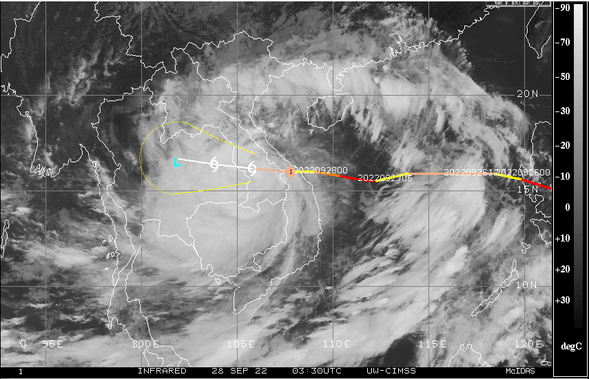
Typhoon Noru in the Northwest Pacific made landfall in Vietnam in the wee hours today. The storm struck near popular beach resort city of Da Nang as Cat-II equivalent hurricane, packed with strong winds of the order of 175kmh. The tropical storm has weakened to Cat-I now and is centered around 16°N and 108°E, about 90km east of Da Nang. It is likely to degrade further to a severe cyclonic storm accompanied with gusty winds in excess of 100kmh, in the next 12hr. The storm will drop intensity to become weak cyclonic storm by tomorrow morning.
Within 36hours, after Noru left a trail of destruction in Philippines, the storm made another landfall in Vietnam. After leaving Philippines, where it was named ‘KARDING’, the typhoon had strengthened again in South China Sea to Cat-IV category. However, it struck Vietnam as Cat-II but still powerful enough to order shutting down of ports and airports, well before landfall. All vessels, boats, fishermen and labourers were ordered to vacate. Mass evacuation to safe shelters was carried out and curfew imposed to restrict movement. The storm will push its way over inland across Southeast Asia, covering Central Vietnam, Southern Laos and Northern Thailand in the next 48hr. All these pockets face the risk of extremely heavy rains accompanied with strong winds and flooding in the next 48hr.
Typhoon Noru will weaken further to low pressure area, as it approach Arakan coast and Gulf of Martaban over North Myanmar on 30thSeptember. The remnant of the storm will emerge over East and Northeast Bay of Bengal as cyclonic circulation on 01stOctober. The pre existing circulation over West-Central Bay of Bengal will get subsumed and a broad circulation will cover large part of East, Central and Northwest Bay of Bengal. A low pressure area is expected to form and likely to move inland on 04thOctober.
This weather system will take the rains deep inside, traversing across Odisha, West Bengal, Bihar, Jharkhand, Chhattisgarh, Andhra Pradesh, Maharashtra, Madhya Pradesh and Gujarat. The low pressure is likely to recurve and extend the rain belt to East Rajasthan, North Madhya Pradesh, Delhi, West Uttar Pradesh and Uttarakhand. Weather activity associated with this system will commence with eastern parts on 02nd Oct and progress to cover the central and northern parts of the country between 04th and 09th October. Perhaps, the monsoon withdrawal will get delayed due to deep inland penetration of this weather system.
