
Super Cyclone, the top most category of storms is considered infrequent and rather freak over the Indian basins. Courtesy climate change, the number is increasing and the Indian Seas witnessed 2 super cyclones in succession during 2019 and 2020. The year 2021 came very close when cyclone Tauktae headed for Gujarat on 17th May and mercifully escaped the fury of a super cyclone, albeit got impacted with the destructive potential of an Extremely Severe Cyclonic Storm. Hat-Trick was averted by a small margin and the record got held in abeyance.
Cyclones get categorized according to the wind speed associated with them. Anything in excess of 220km/h rates the storm as a super cyclone. Tauktae came very close to it and measured nearly 200kmh while short of coast in the deep sea and missed the mark by a whisker. Even the super cyclones in the Indian seas tend to weaken before the landfall because of terrain interaction, cooler water surface, increased vertical wind shear and entrainment. It has happened, by and large with all the storms observed in the last 2 decades.
Since the year 2000, only 3 super cyclones have formed in the Indian season on either side of the coastline. And 2 of them were in a row, Kyarr in 2019 and Amphan the very next year. Before the escalation of the cyclone matrix, as observed in the recent past, probabilistic assessment of about 7-8 years interval was considered as a genuine gap between the 2 super cyclones over Indian basins. This assumption, albeit based on scientific data, seems to be changing.
In the 21st century, super cyclone 'Gonu' was the maiden storm in 2007 over the Arabian Sea. The cyclone seen between June 01-June 07 reached its peak speed of 240kmh on 03rd June while over the open waters of the ocean. Environmental conditions and a cool pocket of ocean water weakened it before making landfall on 05th June. The storm struck the easternmost tip of Oman. Gonu went on record to become the strongest tropical cyclone to hit the Arabian Peninsula.
The next super cyclone took 12 years when storm 'Kyarr' formed, again over the Arabian Sea but this time in the post-monsoon season. The life cycle of this storm lasted from October 24 to November 01, 2019. This was first reported as a cyclonic storm on Oct24 and later intensified to a super cyclone on Oct 27. This was the first super cyclone in the basin since Gonu of 2007. The cyclone achieved the peak wind speed of 240kmh but started weakening from Oct 29th onward, while over the sea itself. The cyclone veered westward and dissipated off the coast of Somalia on Nov 01.
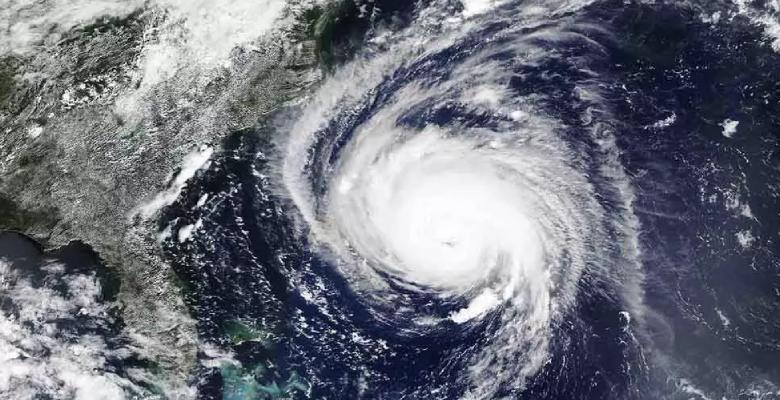
Following Kyarr was super cyclone Amphan changing the goalpost to the Bay of Bengal. The first 'Super Cyclone' in the basin for over 2 decades, after the ravaging super cyclone named as 'Odisha Cyclone' of 1999. Amphan traveled over the ocean for 5 days between May 16 and May 20, 2020. This super cyclone had undergone explosive intensification from Cat-I equivalent hurricane to Cat-IV, in just 6hr, on 18th May. It became a super cyclone on 19th May and made landfall on 20th May near Bakkhali (West Bengal) as an Extremely Severe Cyclonic Storm.
Cyclone Tauktae had enough energy to be another super cyclone but far the vertical wind shear and loss of heat potential, confining it to an Extremely Severe Cyclonic Storm. Again, it was nearly 2 decades for the state of Gujarat to have a storm of this dimension striking the coastline, after the 'Gujarat Cyclone' of 1998. It is good to miss a hat trick and avert the catastrophic damage of life and assets.
