
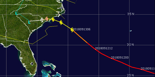
 The National Hurricane Centre had downgraded Hurricane Florence from Category 4 to Cat 3 and eventually, the storm is now a Cat 2 Hurricane. Currently, the hurricane is centered around 31.5°N and 73.2°W about 500 km from the coast, moving in a northwest direction. The system is likely to move in a northwest direction and then later follow a west-northwest direction.
As Florence moves close to the coast, the system is likely to weaken further due to its proximity of the coast along with relatively lower sea temperatures, wind shear as well as possible entrainment.
Thus, Florence may even strike as a Category 1 Hurricane. But this does not mean that the system is any less catastrophic. Its landfall may be over southern parts of North Carolina affecting North and South Carolina as well as Virginia by Friday morning local time.
Thus, extremely heavy rains, flash floods, high velocity winds, along with a storm surge of over 10 feet is expected. In fact, when the system hits the coast, it may have a tendency to move slowly and stall a little prolonging its stay over that weather which will further extend the inclement weather wrath for longer duration.
Also, the area of influence may further expand giving rains over Pennsylvania, Delaware, as well as New Jersey. While the strength of Florence is fluctuating but it will cross coast as not only a hurricane but also with speed over 150 kmph. Moreover, the wind speed and the storm surge are also explicit causing extremely heavy rains resulting in inundation and water logging in many areas.
Image Credit: CIMSS
Please Note: Any information picked from here must be attributed to skymetweather.com
