
By Sunday, Storm Philippe was running up the Atlantic Ocean off the East Coast, moving away from Florida at about 31 mph, with persistent gusty winds of about 50 mph. According to the National Hurricane Centre, storm Philippe was formed near western Cuba a few days back.
It was seen tracking up the east coast, generating high winds and rains in several parts of eastern New York and New England late Sunday into Monday.
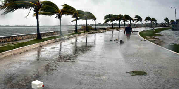
It seemed that the 2017 Atlantic hurricane season could not head into its closing month without spawning Tropical Storm Philippe which ruined much of South Florida’s weekend. The settlement is a new week starting out with cooler temperatures and pleasant weather completely.
Also, Philippe dissipated Sunday afternoon after spinning up at least two tornadoes in Palm Beach County. This created more damage to homes and power lines as the ferocious winds and incessant rains were seen heading towards New York.
[yuzo_related]
The Northeast struggled with power outages and traveling delayed on Monday as the leftovers of Tropical Storm Philippe passed through the area.
The storm soaked the region over the weekend before sprinting into Canada early Monday. It left behind engorged rivers and downed trees that damaged rail and roadways and snarled traffic. Nearly a quarter of a million people were without electricity supply.
Moreover, incessant rains continued across the region on Sunday as the storm merged with a low-pressure system from the Great Lakes on Monday evening.
The government said it was unable to restore power on Monday because of widespread destruction and the danger of downed power lines.
In addition, a government spokesperson stated that the first priority is public safety, and crews are busy grounding and de-energizing downed lines so they do not pose a danger to the public.
For many, the storm was an unpleasant reminder of Superstorm Sandy, which thrashed New York and New Jersey 5 years ago.
Conditions across the region will slowly improve Monday onwards as the low-pressure system drifts into Canada.
The Massachusetts Bay Transportation Authority warned travelers to anticipate delays, because of flooding and strong gusty winds that thumped trees down over rail and roadways.
Image Credit: CNN
Any information taken from here should be credited to skymetweather.com
