

Heavy Rainfall Over Gujarat, Madhya Maharashtra, South Rajasthan, Southwest Madhya Pradesh: Caution for the Next Three Days

Key Takeaways:
- India recorded 13.6 mm and 16.5 mm of rainfall on two successive days, over 50% above the respective daily normals.
- The Pan-India seasonal rainfall deficit has narrowed from 23% to 19%, while July’s deficit has dropped to 1.2%.
- Heavy to very heavy rain will continue across Gujarat, South Rajasthan, Southwest Madhya Pradesh and Madhya Maharashtra.
- Rain intensity and coverage will gradually decrease, with weather activity expected to cease across the region from July 27.
- Forecast Validity: Next 3 to 5 days.
Advertisement
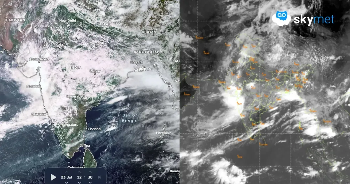
The last two days have been the rainiest for the country during this season. Courtesy of a cyclonic circulation over central parts and a shear zone along 22°–23°N, heavy to very heavy rainfall, exceeding 100 mm in 24 hours, was witnessed over Odisha, Madhya Pradesh, Chhattisgarh, Madhya Maharashtra, Konkan and Gujarat. Parts of Punjab, Rajasthan and Jammu & Kashmir also observed heavy downpours at some places.
Advertisement
Pan-India rainfall was 13.6 mm and 16.5 mm against the respective normals of 9.6 mm and 9.8 mm, an excess of over 50% on two successive days. The countrywide rainfall shortfall has dropped from 23% to 19%. Rainfall on such a scale amounts to a deluge in some areas.
The torrential rains in these parts have reduced the July rainfall deficit to a mere 1.2%. The month of July may exceed its normal rainfall figure by a very thin margin, albeit for a day or two. However, this is a remarkable recovery in the state of the monsoon during the third week of July.
The shear zone still persists, with its axis running close to 22°–23°N from North Gujarat to Jharkhand. The embedded cyclonic circulation is very tightly enclosed over the tri-junction of Madhya Pradesh, Rajasthan and Gujarat. The intense convergence zone of the circulation covers all these parts and extends to North Madhya Maharashtra, the North Konkan Coast and South Coastal Gujarat.
Heavy to very heavy rainfall is expected over these parts for the next three days, albeit with reducing intensity and spread from day one to day two and further into day three. The circulation will shift northward slowly and also weaken gradually while remaining over the southern and central parts of Rajasthan. It is likely to fill up substantially by July 26 and vacate the area the following day, on July 27.
The meeting zone of four subdivisions—Gujarat, South Rajasthan, Southwest Madhya Pradesh and Madhya Maharashtra—will witness heavy to very heavy downpours during the next 24 hours. The spread will remain the same, but the intensity will reduce marginally during the subsequent 24 hours.
The core intense zone will shrink further on July 25 and become confined to West and Central Rajasthan and adjoining parts of West Madhya Pradesh. The remnant effect could be seen on July 26 as well. Weather activity will cease over this entire region from July 27 onwards.
Places at risk in Maharashtra include Pune, Nashik, Dhule, Nandurbar, Jalgaon, Ahmednagar and Aurangabad, along with the North Konkan Coast. Other locations include Kheda, Godhra, Dahod, Chhota Udaipur, Tapi, Ahmedabad, Gandhinagar, Rajkot, Amreli, Botad, Bhuj and Naliya in Gujarat.
Stations in Rajasthan and Madhya Pradesh exposed to risky weather include Dungarpur, Banswara, Pratapgarh, Chittorgarh, Jhalawar, Salumber, Dhar, Barwani, Khargone, Burhanpur, Khandwa, Harda, Dewas and Indore. Extreme caution needs to be exercised in and around all these places.
Trending:



