El Nino has reached its peak and is likely to hold strength till Feb 2024. It is expected to enervate sometime around the spring of the Northern Hemisphere. There is the likelihood of turning neutral before the monsoon steps in the Indian sub-continent. It means that the El Nino impact will cease and weather disturbing pattern will ease out. Rather, with the devolving El Nino and the evolving La Nina, monsoon prospects seem to be becoming better.
ENSO: Warming of the equatorial Pacific seems to be at or near its peak. The European Copernicus Climate Change Service ( C3S) said the El Nino event is currently close to peak amplitude. Sea surface temperatures in the Nino region are expected to remain above the El Nino threshold into the spring of the Northern Hemisphere 2024. It also means that the current El Nino event may last well beyond 12 months, against its average duration of 9-10 months. However, the Pacific has been defying these norms earlier by prolonged and strong El Nino between September 2014 and May 2016 and an unparalleled extended triple dip La Nina from July 2020 to Feb 2023.
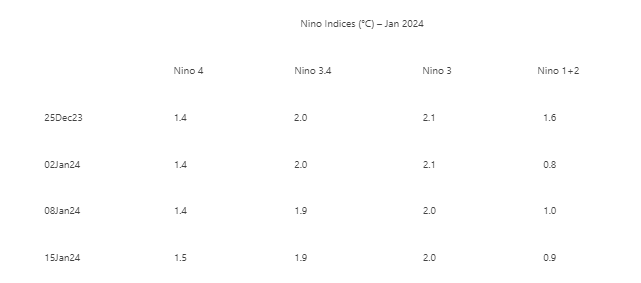
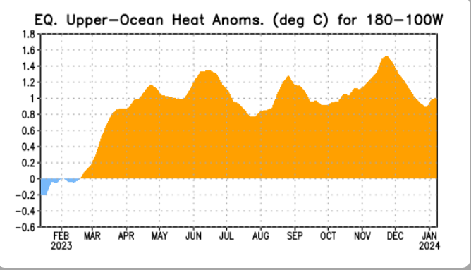
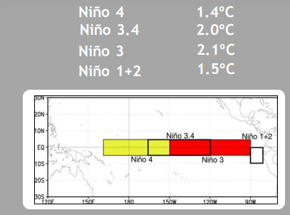
Apparently, the Southern Oscillation Index ( SOI) has pulled out from the ocean-atmosphere coupling. It was running strong since May 2023. The index is drawing close to zero. The mean monthly average for Dec 2023 has slumped to - 0.2 from its earlier value of -0.8 in Nov 2023. The central Nino region comprising Nino 3 and Nino 3.4 continues to surge with adequate heat potential. Flanks albeit, have cooled down, but remain fairly stable with positive anomalies. Nino 3 is holding a positive anomaly of 2°C for over 5 months, since Aug 2023.

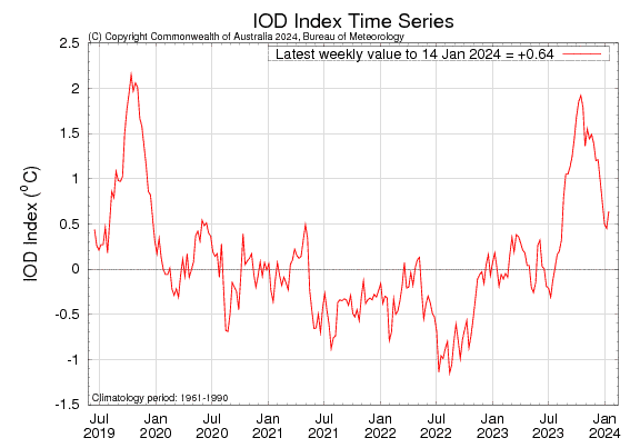
IOD: The positive Indian Ocean Dipole event continues to weaken. However, it may not melt completely without resisting the change. The IOD index is +0.64°C for the week ending 14 Jan 2024, as compared to the value +0.45°C, the previous week. As it is, the IOD event typically breaks down around this time of the year and recommences sometime in April- May. The highest weekly IOD index observed during the season was +1.92°C for the week ending 15 Oct 2023., which is the highest on record since the authentic SST dataset began by the Australian Bureau in 2001.
MJO: Madden - Julian Oscillation had gone through a weakening phase, earlier this month. However, it became quite organized during last week. MJO signal is propagating eastward into the Maritime Continent (phase-4) and steadily growing in amplitude. A large uptick in the MJO amplitude favours enhanced convection over the Maritime Continent. By the end of this month, MJO is heading for the Western Pacific and becomes favourable for Tropical Cyclone formation on either side of the equator. As the enhanced phase of MJO propagates eastward, much of the Indian Ocean looks to become more unfavourable for cyclone development. As such, the northeast monsoon has withdrawn from the Indian region and the probability of cyclone development goes minimal during Jan/ Feb.

El Nino affected India, as the southwest monsoon turned below normal. In turn, the Kharif crop production dropped 3%. August, in particular, turned out to be the driest in 120 years, while October was the 2nd warmest after 2016. As per WMO, in view of El Nino, global temperature in every month between June and December set new monthly records. July and August were the two hottest months on record. Given that El Nino usually has the biggest impact on global temperatures after it peaks, 2024 could be even hotter.