
Updated on November 19, 11:50 am – Deep Depression in Arabian Sea to weaken, moving away from Indian coast
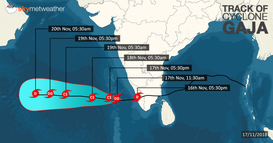
It has been quite a long journey for Cyclone Gaja. The system which is now seen as a deep depression continues to maintain its strength for the last 24 hours. It is presently centered around latitude 11.2°N and longitude 67°E, about 600 km west-northwest of Agathi, Lakshadweep Islands.
According to Skymet Weather, the system would continue to move in westward direction, away from the Indian coast. Not only this, the deep depression showing signs of weakening by Monday evening. Looking at this, we expect system to reach Yemen or Oman coast as a weakened system only,
The only good that this system is doing to Indian coast is maintaining the flow of humid easterly and northeasterly winds over Kerala. This has resulted in on and off light rains over Kerala.
Updated on November 18, 10:30 am – System to maintain strength as Deep Depression for next 24 to 36 hours
Yesterday’s Deep Depression which was lying over Southeast parts of Arabian Sea and adjoining parts of Lakshadweep Islands, has now moved West-northwestwards and presently lies over about 320 kms West-southwest of Agatti. This system continues to move West-northwestwards and is likely to maintain its strength as a Deep Depression only, during the next 24 to 36 hours. Thereafter, the system will gradually weaken into a Depression and will move West-northwestwards away from Lakshadweep Islands.
Updated on November 17, 05:00 pm – Cyclone Gaja: Deep-depression to become cyclonic storm again, heavy rains to lash Lakshadweep Island
The Deep Depression over Southeast Arabian Sea moved westwards with a speed of 20 kmph and at present lies over Southeast Arabian Sea near latitude 09.8°N and longitude 73.2°E, about 50 km west/southwest of Kalpeni, 110 km south/southeast of Kavaratti and 150 km south/southeast of Agatti.
This system is likely to intensify further into a Cyclonic Storm during next 12 hours. It is also likely to move in west direction across Lakshadweep Islands during next 24 hours.
Due to this system, we expect heavy to very heavy rain with few extremely heavy falls over isolated places of Lakshadweep Island. Squally wind speed reaching 55-65 kmph gusting to 75 kmph are also likely over southeast Arabian Sea and Lakshadweep area.
Strong storm surge is likely to inundate low lying areas of Lakshadweep Islands at the time of crossing of the likely cyclonic storm.
Updated on November 17, 11:45 - Cyclone Gaja weakens into deep-depression; Kerala, Lakshadweep rains to continue
The deep-depression over Kerala Coast and adjoining Southeast Arabian Sea has further moved westwards and presently lies around 200 km east/southeast off Lakshadweep Island. This system is further likely to intensity into a deep-depression and may even intensify into a cyclonic storm.
Heavy rains with few very heavy spells are likely to lash Kerala and Lakshadweep region during next 24 hours. Squally wind speed reaching 40-50 kmph gusting to 60 kmph are likely over Southeast Arabian Sea and Lakshadweep Area during next 48 hours, along with Kerala coast during next 24 hours.
Updated on November 16, 02:00 pm - Cyclone Gaja weakens into deep-depression; Tamil Nadu, Kerala rains to continue
Cyclonic storm Gaja which was moving westwards has now weakened into a deep-depression. At present it is situated at 10.5˚N and 77.6˚E about 80 km northwest of Madurai with wind speed of 50-60 kmph gusting up to 70 kmph.
This system is expected to continue moving westwards and weaken further into depression during the next 6 hours near Kerala and Tamil Nadu coast. Thus, rains are expected to continue over Tamil Nadu, Kerala and South Interior Karnataka.
Updated on November 16, 09:45 AM: Cyclonic Storm Gaja continues to lash heavy rains over Tamil Nadu
Severe Cyclonic Storm Gaja made its landfall around 02:00 am today. It crossed Tamil Nadu & Puducherry coasts between Nagapattinam and Vedaranyam with a wind speed of about 100 kmph gusting up to 120 kmph.
At 05:30 am today, the severe cyclonic storm weakened into a cyclonic storm and currently lies 10.3˚N/78.9˚E about 85 km west of Adirampattinam with wind speed of about 75-80 kmph gusting up to 95 kmph. It is likely to move in west direction and weakened into a deep depression during next 06 hours.
In wake of this severe cyclonic storm, heavy rainfall activity has been recorded over many parts of Tamil Nadu. In fact, since morning Cuddalore has recorded 87 mm of rain, followed by Puducherry 65 mm, Nagapattinam 64 mm, Parangipettai 62 mm, Kodaikanal 61 mm, Karaikal 54 mm, Pamban 47 mm and Thondi 34 mm.
Due to the storm’s westwards movement, interior parts of Tamil Nadu along with Kerala and isolated pockets of South Interior Karnataka are also expected to receive heavy to very heavy rain.
Updated on November 16, 2:30 AM: Severe Cyclone Gaja hits Tamil Nadu, heavy rains lash the state
The severe cyclonic storm Gaja over southwest Bay of Bengal had finally made a landfall on Tamil Nadu coast just after the midnight. The system has crossed the coast between Nagapattinam and Vedaranniyam.
At the time of landfall, the wind speed was to the tune of 100 kmph -110 kmph gusting to 120 kmph. Now as the system is travelling in unfavourable conditions, it is very likely to weaken into a cyclonic storm soon.
As per weathermen, the system would continue to move in west direction over the land towards Kerala. We have already reiterated that Gaja would now head towards Arabian Sea and reemerge as a low pressure area there.
In wake of this, heavy to extremely heavy rains have already been lashing several parts of Tamil Nadu, particularly the southern parts.
Updated on November 15, 9:30 PM: Severe Cyclone Gaja about 100 km away from Tamil Nadu, to hit coast by midnight
The outer periphery of Severe Cyclone Gaja is now touching Karaikal and Nagapattinam coast. The storm is now less than 100 km away from making the landfall on South Tamil Nadu coast, most likely between 12 am to 1 am.
Intensity and spread of rain would now start increasing. Besides this, wind speed has also picked up pace. At the time of landfall, we are expecting wind speed to the tune 80 kmph-90 kmph, even gusting up to 100 kmph.
Rains of varying intensity have already started over many areas of Coastal Tamil Nadu including Cuddalore, Nagapattinam, Karaikal, Thanjavur, Tiruvarur, Tuticorin, Pudukkottai, Ramanathapuram and Ariyalur. Chennai have also reported light rain and we do not expect much change in the situation.
Updated on November 15, 6:00 PM: Severe Cyclone Gaja to weaken before hitting Tamil Nadu tonight
Nearing the coast further, the Severe Cyclonic Storm Gaja over southwest Bay of Bengal continues to move in west-southwest direction.
Gaja is centered around latitude 11.2°N and longitude 82°E, about 230 km southeast of Chennai and 180 km east-northeast of Nagapattinam. It has been moving at a speed of 22 kmph during the last six hours.
With landmass approaching, Gaja would very soon start encountering high vertical wind shear and low sea surface temperatures that would lead to weakening of the system very soon.
Gaja would make landfall at the South Tamil Nadu coast between Pamban and Cuddalore, near Nagapattinam as a Cyclonic Storm only tonight. The wind speed along the coast have already picked up pace and are presently around 30-40 kmph. At the time of landfall, squally winds would be around 80-90 kmph gusting to 100 kmph.
We can expect heavy to extremely heavy rainfall over southern districts, particularly over Cuddalore, Nagapattinam, Karaikal, Thanjavur, Tiruvarur, Tuticorin, Pudukkottai, Ramanathapuram and Ariyalur. However, Chennai along with the northern parts of Tamil Nadu would escape the fury of the storm and would settle with light to moderate rains with few short spells of intense rains.
Andhra Pradesh would also see rainfall at many places with some heavy spells over one or two coastal stations. Kerala, particularly southern parts would see similar activity.
Sea conditions would remain rough to very rough all along and off Southwest Bay of Bengal, especially over Tamil Nadu, Puducherry and South Andhra Pradesh. Locals and fishermen are advised not to venture out in the sea for the next 24-48 hours.
Storm surge of height may reach to about 1 meter above astronomical tide which have potential to inundate low lying areas of above mentioned districts of Tamil Nadu and Puducherry during landfall.
Updated on November 15, 1:56 PM- Gaja becomes severe cyclonic storm, to hit Tamil Nadu tonight
Tropical cyclone Gaja over Southwest Bay of Bengal has further intensifies and is now seen as a severe cyclonic circulation. continued to track west-southwestwards at a speed of 14 kmph during the past six hours. It is centered around 11.3°N and 82.6°E, about 320 km of east-southeast of Chennai and 300 east-northeast of Nagapattinam.
Updated on November 15, 9:56 AM- Cyclone Gaja to intensify further, to hit Tamil Nadu today
Tropical cyclone Gaja over Southwest Bay of Bengal continued to track west-southwestwards at a speed of 14 kmph during the past six hours. It is centered around 11.4°N and 82.7°E, about 370 km of east-southeast of Chennai and 370 east-northeast of Nagapattinam.
Atmospheric conditions are indicating that Gaja may intensify into a severe cyclone anytime soon. According to Skymet Weather, sea conditions are favourable with sea surface temperatures (SST) around 28°C or 29°C and vertical wind shear is also low around 10-15 knots.
However, as the coast is not very far away, it would retain the strength of a severe cyclone for very brief duration and would probably make landfall as a cyclone or even as a deep depression. With land mass approaching, Gaja is expected to encounter moderate to strong vertical wind shear and SSTs are also likely to be low. All this will lead to weakening of the system.
The tropical storm would continue to move in west-southwest direction and is likely to hit Tamil Nadu near Nagapattinam by Thursday evening. At the time of landfall, surface wind would be around 80 kmph-90 kmph gusting up to 100 kmph. Storm would surge up to 4 to 6 feet.
Cyclone would give heavy to very heavy rains with some extremely heavy spells over South Coastal Tamil Nadu. Places such as Cuddalore, Nagapattinam, Pudukkottai and Thanjavur would see the major spell of rains.
Right after the landfall, Gaja would degenerate rapidly. However, it is expected to re-emerge in Arabian Sea as a low pressure area on November 18.
Updated on November 14, 09:56 - Cyclone Gaja to cross Tamil Nadu Coast by November 15 evening between Cuddalore and Nagapattinam
Tropical Cyclone Gaja moved in west/southwest direction and today at 08:30 hours, it was near latitude 13.0˚N and longitude 85.1˚E about 540 km east of Chennai and 640 northeast of Nagapattinam.
Cyclone Gaja will continue to track in west/ southwest direction towards Tamil Nadu Coast and may intensify into a severe cyclone by today evening. Intensification is expected due to the favourable weather conditions. Sea surface temperatures are around 29˚C to 30˚C and vertical wind shear has also reduced to 10 to 15 knots.
Gaja is expected to cross Tamil Nadu Coast by November 15 evening between Cuddalore and Nagapattinam. Before reaching the coast, this severe cyclone may once again weaken into a cyclonic storm as the sea surface temperatures near the coast are cooler and we expect vertical windshear to increase. Wind speed at the time of landfall will be around 80 to 90 kmph. Sea conditions will also be rough.
Updated on November 13, 16:05: Cyclone Gaja to lash rains over Tamil Nadu, Kerala and Andhra Pradesh Coast by tomorrow morning
Cyclone Gaja has moved west/northwest wards during the last 6 hours and today at 11:30 hours, it was near latitude 13.5˚N and longitude 86.6˚E about 690 km east/northeast of Chennai and 790 km east/northeast of Nagapattinam.
It is expected to intensify into a severe cyclone by tonight and on November 15 it will once again weaken into a cyclonic storm. It is expected to cross Tamil Nadu Coast near Nagapattinam on November 15’s afternoon.
Wind speed will be around 70 to 80 kmph gusting up to 90 to 100 kmph at the time of landfall.
Updated on November 13, 10:17: Cyclone Gaja to become a severe cyclonic storm shortly
Cyclone Gaja tracked in north/northwest direction during the last 6 hours. At 5:30 am today, it was near latitude 13.2˚N and longitude 87.2˚E about 750 km east of Chennai and 840 km east/northeast of Nagapattinam.
At present is lies over West central and adjoining East central and South Bay of Bengal. It is expected to intensify further into a severe cyclone as sea surface temperatures are favourable for intensification that is around 29 to 30 degree.
Cyclone Gaja is encountering moderate wind shear around 15 to 20 knots. It will once again resume its movement in southwest direction after some time. Due to the subtropical ridge to the north, it is expected to cross Tamil Nadu Coast between Cuddalore and Nagapattinam on the afternoon of November 15.
Updated on November 12, 2018 at 16:25 - At 11:30 am today, Cyclone Gaja was over West central and adjoining East central Bay of Bengal near latitude 12.9˚N and longitude 86.9˚E about 720 km east/northeast of Chennai and 800 km east/northeast of Nagapattinam.
Gaja will continue its movement in west/southwest direction. It is expected to intensify into a severe cyclonic storm by tomorrow. It will maintain its intensity of severe cyclone until November 14.
Due to moderate wind shear it is expected to weaken gradually before crossing the coast of Tamil Nadu around forenoon on November 15 between Cuddalore and Nagapattinam.
Updated on November 12, 2018: Cyclone Gaja to become a severe cyclonic storm shortly
Cyclone Gaja which was stationed over west-central and adjoining east-central and southeast Bay of Bengal has now moved further westwards at 6 kmph in the last few hours and is now over west-central and adjoining east-central Bay of Bengal near Lat. 13.4°N and Long. 87.1°E, about 740 km ENE of Chennai and 840 km ENE of Nagapattinam. The system will move west south-westwards becoming a Severe Cyclonic Storm during next 24 hours and maintain the intensity during the subsequent 24 hours.
Thereafter, while moving westsouthwestwards, Gaja will gradually weaken and cross North Tamil Nadu coast between Nagapattinam and Chennai as a Cyclonic Storm during the forenoon hours of November 15.
Published on November 11, 2018: As predicted, the deep depression in Bay of Bengal has finally intensified into the cyclonic storm Gaja and is presently marked over East central and adjoining West central and Southeast Bay of Bengal.
Moving in west-northwestwards, the system is centered around Latitude 13.4°N and Longitude 89.3°E, around 390 km west-northwest of Port Blair, 990 km northeast of Chennai and 1050 km east-southeast of Nellore.
According to weathermen, the system is moving in extremely favourable conditions for its further intensification. Gaja is most likely to get more marked into a severe cyclonic storm during the next 24 hours.
As per Skymet Weather, there is long sea travel ahead for Gaja, along with that sea surface temperatures are also warm and low vertical wind shear. Besides this, Madden-Julian Oscillation (MJO) is also in the favourable zone. All these factors would be responsible in providing more strength to the system.
Weather models are indicating that the cyclonic storm would continue to track west-northwestwards during the next 36 hours. Thereafter, it would change the direction and move west-southwest wards towards the coasts of North Tamil Nadu and South Andhra Pradesh during the subsequent 48 hours.
Usually, majority of the weather systems forming in Bay of Bengal during November head towards Tamil Nadu.
However, as the system nears the coast, it would start weakening gradually. However, the system would make landfall as a cyclone. Gaja is likely to cross the North Tamil Nadu and south Andhra Pradesh coasts by the forenoon of November 15.
As of now the system is quite far away from the Indian mainland to give any weather over the region. However, Andaman and Nicobar Islands are likely to record fairly widespread rainfall with some heavy spells as well.
Sea conditions would remain rough to very rough during this this time and fishermen are not advised to venture out in the sea.
Scattered rains will commence over Chennai and coastal Tamil Nadu around November 14. As the system nears, intensity would also rise, and we expect heavy to very heavy rains over the area on November 15.
Intensity of rains would start decreasing by November 16, but many districts of Tamil Nadu and South Interior Karnataka would continue with good rains.
Sea conditions will become rough to very rough from November 13-16 over southwest Bay of Bengal off Tamil Nadu and south Andhra coast. Fishermen are advised not to venture into the sea during this time.
Image Credits – cimss
Please Note: Any information picked from here must be attributed to skymetweather.com
