
2018 has been an intensive cyclone year for the country. We have seen series of cyclones right from the pre-Monsoon season to post-Monsoon as well as during the Monsoon also, which holds the least possibility of formation of any cyclonic storms.
According to Skymet Weather, this year is extremely productive year in terms of tropical storms, otherwise there have been years when we do not see even one cyclone.
Pre-Monsoon season saw Cyclone Sagar and Mekunu, while Cyclone Daye made way during the Southwest Monsoon 2018. Post-Monsoon season also started on an active note with Cyclone Luban and Titli forming simultaneously in Arabian Sea and Bay of Bengal, respectively.
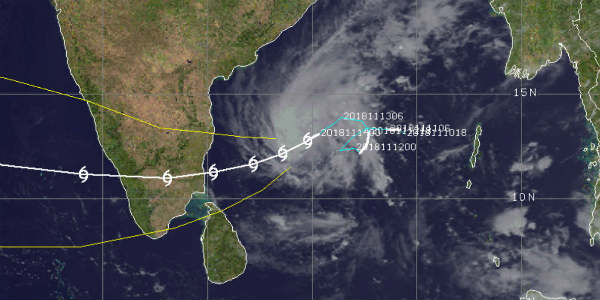
At present is Cyclone Gaja churning in Bay of Bengal, which is the sixth in the row. However, weathermen are of the view that although frequency has been more this season, but all these systems lack in intensity linked with cyclonic storm. In short, all of them had limited damage potential that too for a short duration and with advance preparedness, the casualties were also curtailed to few.
Either they have gained strength while they have moved away from the Indian coast or have weakened before hitting the coast. Also, most of the cyclones forming in Bay of Bengal during November usually head towards Odisha and Andhra Pradesh and towards Tamil Nadu in December. However, this season has seen all sorts of combination. Similar situation is seen with the current cyclonic storm Gaja.
The strength of the system is gauged by the amount of sea travel and Gaja has been there for more than a week now. In fact, all the possible conditions which lead to enhancement of the systems like latitude, moisture, warm sea surface temperature and low wind shear, all were present. Besides this, MJO is also in the favourable zone. But in spite all these, Gaja is still struggling to gain strength.
Though weather models are indicating that Gaja would will pick up strength and become severe cyclone shortly but that will happen for a short while. The storm would soon encounter with the coast and simultaneously losing latitude. As per the metrological rules, any southward movement of the weather system in Northern Hemisphere works against the growth of the system.
Meanwhile, one good thing about this system is that it would be helpful in improving the rainfall deficiency for Tamil Nadu. With Northeast Monsoon making much delayed onset, Tamil Nadu has been battling over high rainfall deficiency i.e. over 50%. Even after the arrival of three-month long season, there has been no significant rainfall over the state.
The clock is ticking as the time is passing because as the December nears, the average rainfall for the state also decreases. Thus, Cyclone Gaja would be benefit Tamil Nadu in terms of satisfactory Monsoon rains without exposing it to the fury of the storm.
Image Credits - cimss
Please Note: Any information picked from here must be attributed to skymetweather.com
