Updated on April 30, 2019 10:00 AM: Fani intensifies into very severe cyclonic storm, to become extremely severe cyclone soon
As expected,severe cyclone Fanihas intensified into a very severe cyclonic storm in the wee hours of Tuesday. Moving north-northwestwards, Fani has now moved over southwest and adjoining southeast Bay of Bengal.
The maiden storm of the season is now centered at latitude 11.7°N and longitude 86.5°E, about 650 km east-northeast of Trincomalee, Sri Lanka, 680 km east-southeast of Chennai, Tamil Nadu and 750 km southeast of Machilipatnam,Andhra Pradesh.
Fani is still travelling in conducive weather conditions of warm sea surface temperatures and low vertical wind shear. Thus, Fani is very likely to intensify further into anExtremely Severe Cyclonic Stormby the night of May 1 or early morning of May 2.
As per the weathermen,Faniwould be most powerful i.e. it will strengthen into extremely severe cyclone when it would be abeam Kavali, Andhra Pradesh.
We are now expecting slight change in the direction of the Fani, which is now likely to move northwestwards fir the next 24 hours. Thereafter, cyclonic storm Fani would recurve north-northeastwards towards Odisha Coast.
Very severe cyclone Fanihas already start impacting the weather over Indian mainland. The system is presently travelling far away from the coast, but its feeder bands have started giving rains over Kerala. Sri Lanka too have recorded very heavy rains.
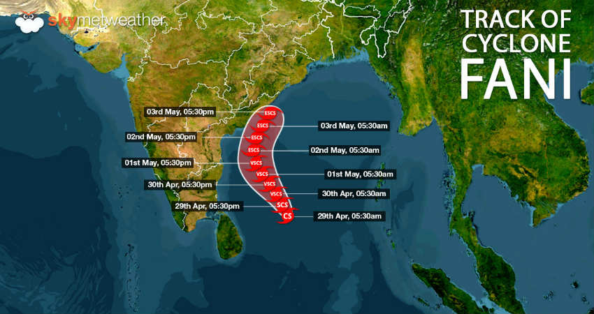
Updated on April 29, 2019 10:00 AM:Cyclone Fani shows signs of severe cyclone, to become extremely severe cyclone thereafter
In the last 24 hours, Cyclone Fani continues to gain latitude as it moved further northwards. It is presently centered at Latitude 8.6°N and Longitude 86.9°E over southeast Bay of Bengal and adjoining areas. This is around 600 km eastsoutheast of Trincomalee, Sri Lanka, 840 km southeast of Chennai and 1000 km southsoutheast of Machilipatnam.
The movement of the Cyclone Fani has become extremey slow as it has been travelling at the speed of 4 kmph - 5 kmph during the last few hours.
However, Fani has become more organised. In fact, atmospheric conditions and cloud configuration are indicating that it has strengthened into severe cyclonic storm. Skymet Weather reiterates that the cyclonic storm is still travelling extremely conducive environment. Sea surface temperatures are still in the range of 30°C to 32°C and vertical wind shear is also low.
Looking at its slow progress amidst the favourable sea condition, Fani has lot more chances of turning into a very severe cyclone in the next 24 hours and thereafter into an extremely severe cyclone in subsequent 24 hours.
Read more at: Slow progress and MJO to intensify Cyclone Fani into extremely severe cyclone
Updated on April 28, 2019 11:00 AM:Cyclone Fani all set to become severe cyclone shortly, very severe cyclone likely in 24 hours
TheCyclonic Storm Faniis likely to gain more strength and intensify into a severe cyclonic storm by Sunday afternoon. It is presently centered at Latitude 7.3°N and Longitude 87.9°E over southeast Bay of Bengal and adjoining areas. This is around 740 km eastsoutheast of Trincomalee, Sri Lanka, 1000 km southeast of Chennai and 1220 km southsoutheast of Machilipatnam.
Fanihas been continuously gaining latitude but weather conditions are still very much favourable for its further intensification. Sea surface temperatures have been very warm to the tune of 31°C and vertical wind shear has also been low. Thus, likely severe cyclonic storm Fani would soon in the next 24 hours would upgrade its status into a Very Severe Cyclonic Storm.
Read more at: Fani to intensify into severe cyclone by Sunday afternoon, very severe cyclone in 24 hrs
Updated on April 27, 2019 4:30 PM:Cyclone Fani arrives in Bay, severe cyclone to follow in 24 hours
Little earlier than expected, the deep depression in Southeast Bay of Bengal have intensified into a cyclonic storm on Saturday afternoon itself. It is presently centered at Latitude 5.4°N and Longitude 88.5°E, about 870 km east-southeast of Colombo, Sri Lanka, 1200 km southeast of Chennai and 1440 km southsoutheast of Machilipatnam.
According to weathermen, the situation is very much conducive forFani to intensify into a severe cyclonic stormin the next 24 hours. In fact, chances are bright for it to gain more strength and attain the status of very severe cyclonic storm by April 29 also.
The system is now likely to move in northwest direction off the Sri Lanka coast and thereafter it is likely to re-curve and move along the East Coast, right from Tamil Nadu to West Bengal and finally heading towards West Bengal.
However, for the next 24-36 hours, intense rains would be confined to sea only and coast would not much of impact. Thereafter, intense rains, high velocity winds and rough sea conditions would be seen all along the coastal areas of Tamil Nadu and Andhra Pradesh.
Updated on April 27, 2019 1:30 PM:Deep depression in Bay to intensify into Cyclone Fani by Saturday evening
Depression in Bay of Bengal has intensified into a Deep depression over Southeast Bay of Bengal. Moving in west-northwest direction, the system would intensify into acyclonic storm Faniby the late night hours of April 27.
The system is presently centered at latitude 4.8°N and longitude 88°E, around 890 km east southeast of Colombo, Sri Lanaka, 1200 km southeast of Chennai, and 1500 km south-southeast of Machilipatnam.
As reiterate, probable storm Fani is travelling extremely in favourable weather conditions of very warm sea surface temperatures to the tune 31°C, low vertical wind shear, gaining latitude and long sea travel.
In wake of this, the weather conditions are very much favourable for the cyclonic storm to strengthen further into a severe cyclonic storm during the next 24 hours.
At present the system is moving in north/northwest direction and by the time it becomes a cyclonic storm, it would move in northwest direction. Thereafter, the system is most likely to recurve and head towards Bangladesh.
However, in all this process, the system would skirt all along the East Coast, beginning right from Tamil Nadu to West Bengal.
As per weathermen, the terrain is such that system would not be able to escape the coastal areas. Tamil Nadu needs to be on alert initially, as would encounter some high velocity winds, moderate rains with some intense showers.
Image Credit:en.wikipedia.org
Any information taken from here should be credited to skymetweather.com