

First triple dip La Nina of 21st century is expected to fade away soon. The current NOAA forecast suggest that La Nina will continue till early 2023, making it one of the longest on record. The anomalies of cool temperatures in the Pacific waters are likely to dissolve, before 'spring' 2023. The scare is that La Nina may have steady transition into an evolving El Nino coinciding with Indian summer monsoon. The warm equatorial Pacific during El Nino exacerbates extreme weather, rampaging across the globe and more so for Indian Sub-Continent.
ENSO : El Nino forecast is available for the next 9 months. However, model accuracy for the lead times greater than 4 months is generally low at this time. Yet, the past record of El Nino indicated around this time, is a testimony of spoiled southwest monsoon. ENSO forecasts of December 2013 and December 2017 were akin to December 2022. Both these years witnessed sub-par southwest monsoon rainfall leading to moderate drought in 2014 and near drought in 2018. Earlier, similar patterns in 2003 and 2008 also proved cataclysmic, defacing Indian monsoon 2004 & 2009, both drought years.
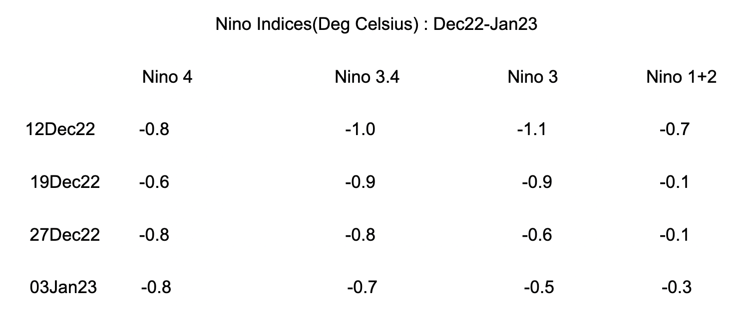
The initial projections indicate ENSO building up sharply and El Nino getting augmented rapidly during monsoon. As of now, the principal indicator Nino 3.4 holds ground and negative anomalies still prevail.

ENSO will continue with equal chance of La Nina and Neutral during Feb-Mar 2023. Chances of Neutral increase significantly during Mar-Apr 2023.

IOD : Sea surface temperatures are close to average across the norther half of Indian Ocean. Indian Ocean Dipole is inactive now and is likely to remain within neutral bounds of +/-0.4 Degree Celsius. The latest value of the index for the week ending 08Jan23 was +0.18deg. Any steep rise is unlikely during northern hemispheric winters.

MJO : Madden Julian Oscillation is an eastward moving "pulse" of cloud and rainfall near the equator and has a recurring period of 30-60 days. Its influence on weather events is better appreciated over the Indian Ocean and West Pacific. It is currently positioned over the Western Pacific and is likely to transit to Atlantic Ocean during next one week. Later, it is likely to come in phase 2 over Indian Ocean with significantly increased amplitude.

El Nino needs to be tracked closely during the next few months. It has a history of erratic behaviour during March-April, popularly mentioned as the 'spring barrier'.
