
El Nino refers to a climatic pattern of consistent warming of the eastern equatorial Pacific Ocean. This natural phenomenon is the most powerful fluctuation in the climate system, anywhere on earth. It causes climatic chaos across the globe and often drought in India. El Nino preceded by La Nina is considered more harmful than any normal occurrence . El Nino this year is following three consecutive years of La Nina – a rare “triple dip” and first of its kind in this century.
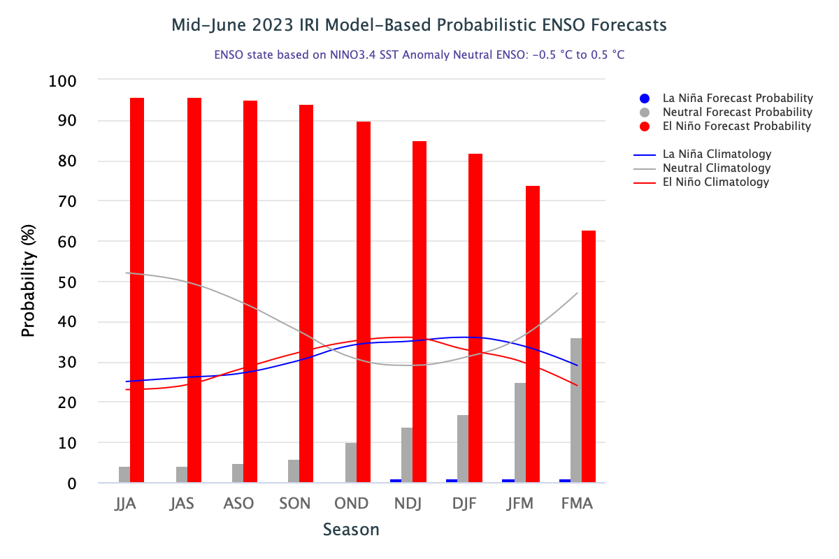
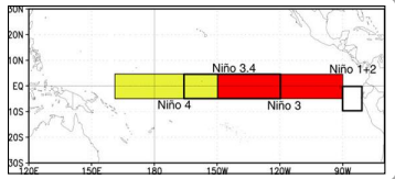
This monsoon disrupting weather phenomenon , invariably has the rise in the Nino indices anomalies in the astern equatorial Pacific Ocean. Nino 3.4 ( Oceanic Nino Index) is a principal measure of assessing, monitoring and predicting El Nino. Positive anomalies of sea surface temperature of >/= 0.5°C is essential requirement for announcing El Nino. Also, such anomalies need to be predicted to stay for longer durations, without any collapse, preferably for 6 months or more.
Warming of sea surface temperature (SST’s) in the eastern Pacific can commence anytime of the year. However, most of the El Nino events tend to develop from April-June and reach their maximum strength between October and February. Typically, they persist for 9-12 months but have occasionally lasted for over 2 years. An El Nino event emerging in early summer and lasting through the monsoon months is considered detrimental and habitually inflict a deficit monsoon.
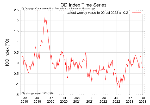
Sufficiently warmed Tropical Pacific releases enormous heat in to the atmosphere. And, when the atmosphere responds in consonance, the ocean – atmosphere coupling leads to this chaotic occurrence. An El Nino does not always reduce monsoon rains. Some other oceanic parameters, if in favor, can save the season from the blues of El Nino. A strong and consistent positive Indian Ocean Dipole can dilute the ill effects of El Nino. However, the recent value of IOD as on 02nd July 2023 was -0.21°C. There was a strong El Nino in 1997, which ended with a marginally surplus monsoon. But then, that has been the only exception in the last 25 odd years.
Monsoon is a very complex and puzzling phenomenon. It is the largest planetary scale system with enormous energy dynamics. Notwithstanding, any acceleration or deceleration on account of influential oceanic parameters, monsoon has the potential to run on its own steam, at least for couple of weeks. Intra-seasonal oscillations are an important component of monsoon variability. These are characterized by seasonal active and break sequences occurring within the season.
Complex monsoon , superimposed with El Nino makes the challenge bigger and tricky. El Nino could have different phases through the Indian Summer Monsoon Rainfall ( ISMR). It could be a standard El Nino, when emerging early in the summers. Late start, beyond summer may be termed as ‘evolving” El Nino . Decay of El Nino during northern hemispheric spring season, spilling over to the monsoon months becomes synonymous with “devolving” El Nino. Degree of ONI can classify these events from Neutral to evolving, devolving or standard El Nino.
Since 2001, Indian monsoon has witnessed all these types of El Nino. Their capacity and magnitude to derail the monsoon rainfall varies for each of the episode.

Seasonal rainfall during the El Nino years has no evident pattern. Broad inferences drawn may not be conclusive, as such. Along with standard El Nino, the evolving El Nino also was unsparing. However, the devolving El Nino rarely has adverse effect. Notwithstanding, there could always be some exceptions in each of these categories.

Monsoon 2023 seems to be an evolving El Nino year. There is an explosive warming closer to the South American coast and shrinking over the central Nino region. These are precursors to the “ canonic’ El Nino. Such episodes are few in number and therefore difficult to draw inferences. El Nino will peak during the ‘autumn’ months and fall of the year. Monsoon 2023 made a delayed and sluggish start. Month of June ended with a deficit of 10%. Courtesy cyclone Biparjoy, the rainfall distribution was heavily skewed. Southwest monsoon has entered an active phases. Substantial recovery has been made with accumulated deficit of June getting marginalized. Break even of the monsoon rainfall is likely in the next couple of days. Monsoon current may slowdown temporarily from 10thJuly but likely to get rejuvenated with some fresh monsoon system.
