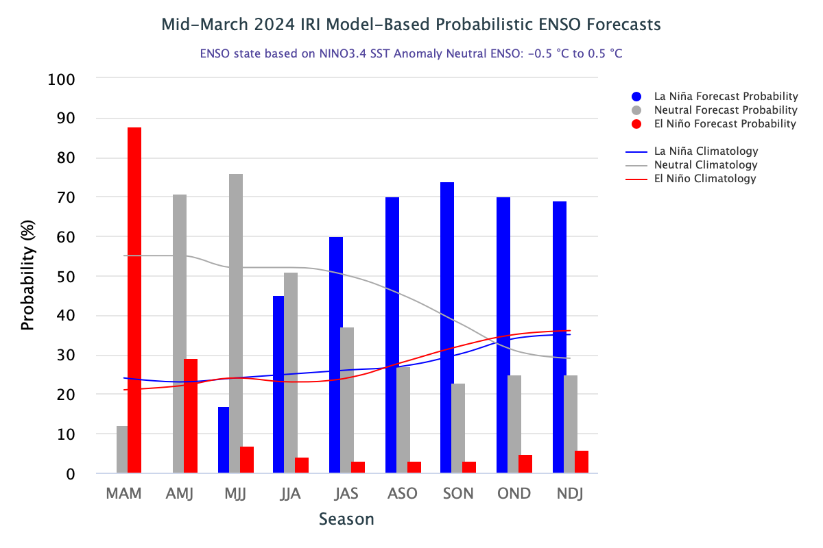
According to the Climate Prediction Center (CPC), an arm of the US National Oceanic and Atmospheric Administration (NOOA), there is 62% chance of La Nina emerging during June-August quarter. This is an increase of about 7% from its earlier assessment of 55%, two weeks ago. “Transition from El Nino to ENSO-neutral is expected by May-July 2024. Therefore, La Nina is favoured in June-Aug and chances increase through the Oct-Dec season” CPC said in its latest update.
El Nino has a strong relationship for its adverse impact on southwest monsoon. La Nina, though considered boon for monsoon, does not enjoy robust correlation. At best, it nullifies monsoon failure on 80% of the occasions. La Nina has a record of below normal monsoon, as well, as it happened in year 1999 and 2000. Though, IOD in 2000 was negative which may not be the case this season. However, La Nina after Super El Nino has a tall history of steering monsoon, safely to normal or above normal rainfall. As per the latest projection, La Nina component is growing from 30% at start of monsoon to 80% by end of September. Fall of the year will witness sustained peak of La Nina, rolling over to winters 2025 of Northern Hemisphere.
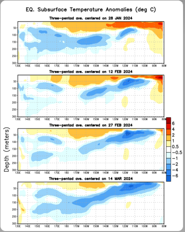
ENSO: Sub surface temperature anomalies have weakened since late Nov 2023. Since late Jan 2024, negative temperature anomalies have gradually strengthened. During the last four weeks, above average sea surface temperatures (SST’s) weakened across most of the equatorial Pacific Ocean.“ In the last couple of weeks, below average SST’s emerged in small region of the eastern Pacific Ocean’ the CPC said.

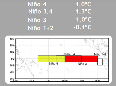
Collapse of positive anomalies in the eastern Pacific may be construed as waning of El Nino, commencing with the flanks. However, Nino 3.4 region, the principal measure for monitoring, assessing and predicting ENSO continue to hold strong and resist any drop in the temperature anomaly. Rather, it has risen to 1.3°C from its last week grade of 1.1°C. Barring Nino 1+2 region, rest all Nino indices have shown rise of temperature. It indicates that El Nino is not going to fade without the fight and may linger on till May 2024.
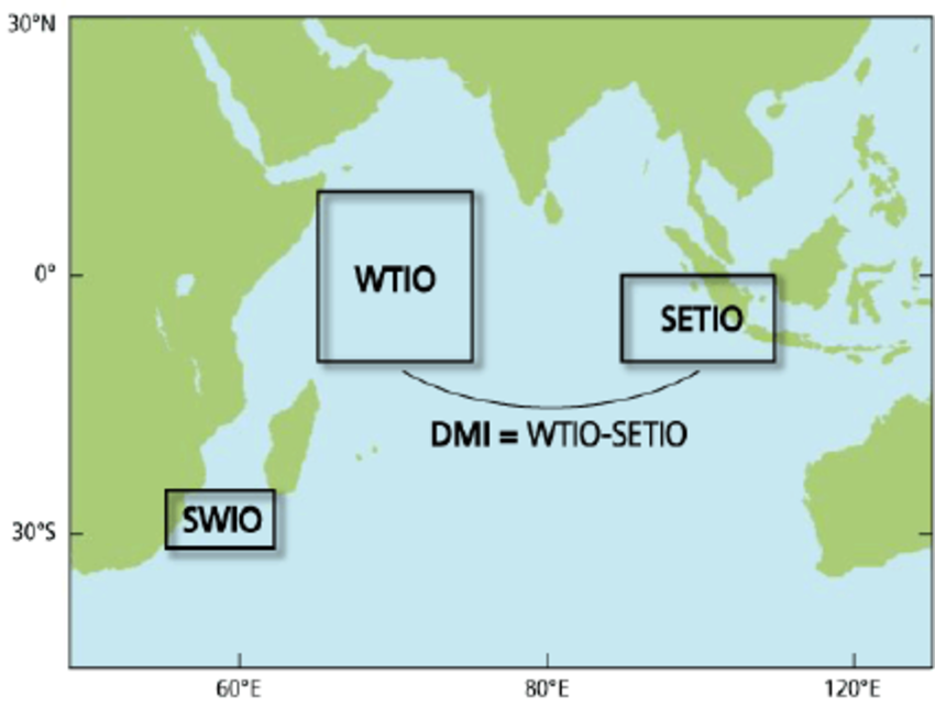
IOD: Indian Ocean Dipole is a coupled ocean-atmosphere phenomenon in the Indian Ocean. IOD also called as DMI, is the temperature difference between West Tropical Indian Ocean and Southeast Tropical Indian Ocean. Positive IOD is characterized by anomalous cooling of SST in the Southeast Equatorial Indian Ocean and anomalous warming of SST over the Western Equatorial Indian Ocean. Associated with these changes, the normal convection situated over the Eastern Indian Ocean warm pool shifts to the West and bring heavy rainfall over the East African region and droughts over the Indonesia region.
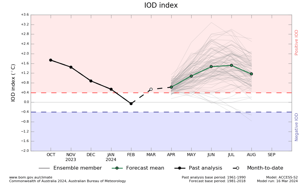
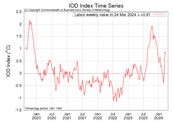
The Indian Ocean Dipole index has remained above the positive IOD threshold for the 2nd consecutive week. The most recent value of the index for the week ending 24 March 2024 was 0.81°C, narrowly below the last week mark of 0.86°C. Sustained values of IOD index above the threshold are required for an IOD event to form. Process of IOD formation, leading to monsoon 2024, may commence in another 3-4 weeks. IOD events are typically unable to form between December and April, when the ITCZ is located south of equator from Australia-Indonesia to southern parts of West Tropical Indian Ocean.
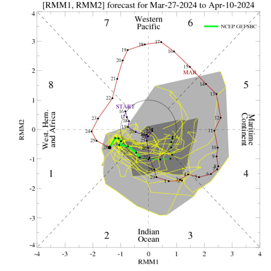
MJO: Madden-Julian Oscillation is transiting through the Western Hemisphere and propagating eastward in Phase 2&3 over Indian Ocean. Amplitude is shrinking and getting barely confined to the inner circle. The upcoming suppressed phase of MJO may tend to impede the tropical cyclone activity, if any. Afterall, month of April hosts fair number of tropical cyclones in the Indian seas, more so over Bay of Bengal.
Southwest monsoon is largely controlled by the oceanic parameters like El Nino, La Nina, IOD, MJO and few others. Fairly strong La Nina is likely to evolve during the monsoon period. Also, positive IOD will improve the monsoon prospects further. MJO remains a transitory phenomenon. Frequent passage of MJO over the Indian Ocean can stimulate the monsoon drivers, more so over Bay of Bengal. All roads are leading to a decent monsoon this season. Yet, many other inputs, still getting ready to be factored in, for comprehensive assessment of monsoon.