
Southwest Monsoon has advanced and covered parts of Karnataka, almost the entire Rayalaseema, South Coastal Andhra Pradesh and the northeastern states of Nagaland, Manipur, Mizoram and Tripura.
We have seen a progressive increase in the Pan India rainfall amount on a daily basis.
[yuzo_related]
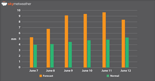
The first fortnight of June started with 2.5 mm and by June 12, we expect the amount to get double and reach up to 5.5 mm.
Monsoon has set in India before the scheduled date, almost three days in advance on May 28. So, the first four days of onset, i.e. May 28, 29, 30 and 31, the rains recorded were more than the normal and subsequently the intensity of the showers varied.
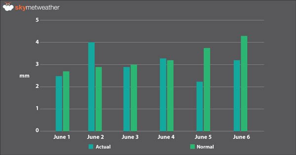
The official date for onset of Southwest Monsoon is June 1. So, the first six days of June, we can say that initially the rains were below normal and then later the showers recorded were above normal. So, marginal difference was seen in the recorded rainfall.
Now, the remaining six days, i.e., until June 12, we expect Monsoon rains to gradually increase. Major pockets that will be the solitary contributor would be Konkan and Goa and Coastal Karnataka. Other than these mentioned regions, the remaining parts of Maharashtra and Karnataka, Telangana, Madhya Pradesh, Chhattisgarh and Andhra Pradesh would also contribute to adequate rainfall.
Any information taken from here should be credited to skymetweather.com
