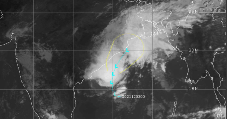
Cyclone Jawad at the moment is a Cyclonic Storm, away from the coast by about 200 km. The storm was earlier moving northwestward but now it is moving more of a northward. During evening, we expect Cyclone Jawad to come abeam Visakhapatnam but still keeping the coastal town about 100 km away from it.
Peripheral clouds have reached the coastline and some rainfall has been seen over some parts of Coastal Andhra Pradesh and some areas of Odisha Coast. Once the system reaches abeam Visakhapatnam in the evening, it will start to recurve and start moving north northeast initially and then northeastward.
At the moment, when it is moving northwestward, the orientation of the coastline is northeast-southwest. Therefore, for the next 12 hours, the storm will keep coming closer to the coast. When the system recurves, it will not completely move away from the coast since the orientation of the coastline is almost the same and the track of the storm will go nearly parallel to one another.
Cyclone Jawad will come the closest to the coast as a weakened deep depression or a depression, when it is near Puri in Odisha. In fact, the system could even brush the coastline of Puri.
By tonight, the system will lose its steam and weaken, crossing the West Bengal coast on the morning of December 6. By tomorrow morning, the system will weaken into a depression or so.
Usually, whenever the storm is moving close to the coastline, two things happen. One of them is that the frictional forces of the land come into play and restrict its growth, the other is the entrainment, which basically means dry air from the land entering the storm. Thus, while the storm is getting energy from the sea, but it is being balanced out by the other two factors restricting the growth.
Also, when the storm comes closer to the coast, the wind shear starts to increase, which again means hindering the growth. As a routine, the sea surface temperatures towards the northern parts of Bay of Bengal are colder as compared to the equatorial regions.
Climatologically and historically, Odisha hasn’t seen a Cyclone in 130 years in the month of December, which is likely to be the case this year as well. For Andhra Pradesh as well, all storms have weakened before crossing the coast during the month of December.
When the system moves across West Bengal, moderate to heavy rains are expected over many parts around December 6. Tomorrow, the system is likely to spend along the coastline of Odisha, resulting in some heavy rains and strong winds. The possibility of three digit rains cannot be ruled out in some parts of Odisha.
However, the fury of the storm including high speed winds and torrential rains may not seen. Nevertheless, even as a weakened system, it has the potential to give some hefty showers over Odisha due to its slow movement along Odisha coast.


