
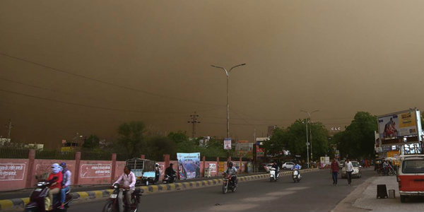
Northwest India has recently encountered the much-anticipated dust storm and thunderstorm activities. However, as hyped, the activities were comparatively much lesser, both in terms of intensity and duration, which was exactly predicted by Skymet Weather.
We have already clarified that pre-Monsoon activities peak in May making it vulnerable to dust storms, thunderstorm, lightning strikes, rain and thundershowers of varying intensity in parts of Northwest India. The arrival of an active Western Disturbance further enhances the pre-Monsoon activities, which was the case last week.
Violent and deadly activities are common during the month until the onset of Southwest Monsoon over the region which is usually in the early days of June. Normally, during this time, Northwest India including the states like Punjab, Haryana, Delhi NCR, West Uttar Pradesh and North Rajasthan are accustomed to witness at least 4-5 episodes of high-velocity dust storms and thunderstorms. Out of these episodes, generally, one or two occasions are such severe intensity which was the case on May 2.
[yuzo_related]
However, the other two so-hyped dust storm and thunderstorm activities were comparatively less intense in nature. The activity that occurred last night was even lesser than the activity that occurred a day before.
As per Skymet Weather, this reduction in the speed and intensity of the activity also has a reason. Dust storm generally is due to wind instability, which does not occur soon after releasing once.
In addition to this, the accumulation of heat is the main triggering factor for the pre-Monsoon activities to take place. However, after the spell of rain and thundershowers last week, the temperatures over the region dipped. Because of this, accumulation of heat could not take place.
This is the fact that the intensity of thunderstorm, dust storm, rain and thundershowers reduced over a period of a week. Moreover, usually, thunderstorms become deadly and dangerous if they are accompanied by strong winds and rain.
However, this time, the thunderstorms were accompanied by light and patchy rains and thus it could not add to the ferocity of the storm.
As per Skymet Weather, though the chaos and hype that surrounded dust storm and a thunderstorm is over, the remnants are expected to give some isolated rains for the next 24 hours. Another fresh Western Disturbance is likely to approach Western Himalayas on May 13 and then another round of dust storm and thunderstorm can be expected.
Hence, a slight relief is in store for almost a week until the next spell occurs.
Image Credit: The Indian Express
Any information taken from here should be credited to skymetweather.com
