
As being predicted by Skymet Weather, rains have begun and are continuing over Northwest Plains of India, only to intensify this morning.
As per the Doppler images, intense clouding and thunderclouds can be seen over many areas. These buildups are potential of bringing along intense lightning and thundershower accompanied with hailstorm at a few places in the next few hours.
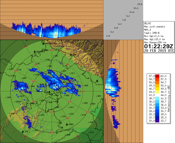
Below is the image of Delhi Doppler Radar showing 27.81% cloud build-up in Delhi at 7:22 am.
At present, intense thunderclouds are seen over many parts of Haryana. We expect light to moderate rain and thundershower activity to occur over places like Hisar, Bhivani, Rohtak, Gurugram, Jhajjar, Jind, Sonipat and Panipat. Lightning strikes and hailstorm activities are possible over a few places.
Lightning and thunderclouds are also seen over many parts of West Uttar Pradesh covering areas such as Muzaffarnagar, Shamli, Bijnor, Bagpat, Amroha, Moradabad, Meerut and Bulandshahar.
The same clouds seem to be covering parts of Northeast Rajasthan as well mainly over places like Alwar, Dausa and Bharatpur. These clouds will bring along isolated rains and thundershower activities along.
Gradually the thunderclouds over Haryana will move over Delhi and NCR due to the blowing Westerly winds. Isolated rain and thundershower activities are possible over Delhi and NCR in the next few hours.
Image Credits – etsy.com
Any information taken from here should be credited to Skymet Weather
