

Sea Surface Temperatures (SSTs) remain below average in the central-eastern equatorial Pacific Ocean. In accordance with prevailing oceanic and atmospheric conditions, weak La Nina continues to prevail. Therefore, the La Nina advisory remains in place. The timings for dissipation of La Nina are still ambiguous. Model-based objective type forecast predicts the continuation of weak La Nina till May and favours a transition to ENSO neutral during April-June. However, the subjective consensus takes this event to May-Jul.
ENSO: Notwithstanding the expected trends, below-average SSTs strengthened during the latter half of February and the 1st fortnight of March 2022. In particular, the weekly Nino3.4 index decreased further from -0.6°C to -1.1°C on 07th March and marginally stepped up to -1.0°C on 14th March. While atmospheric and oceanic indicators suggest the 2021-22 La Nina has already peaked, the decline to ENSO neutral may still not be simple and linear. Regardless of whether La Nina thresholds are sustained for longer or shorter periods, the presence of symbolic pattern itself suffices to influence the normal distribution of rainfall. The strength of the event does not necessarily equal the strength of its effect.
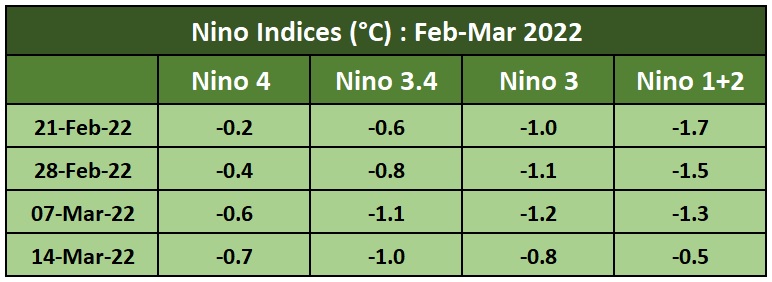
The Oceanic Nino Index (ONI) is based on SST’s departure from average in the Nino3.4 region (120 - 170°W, 5°S - 5°N). This is the principal measure for monitoring, assessing and predicting ENSO. The forecasters' consensus favours a slower decay of La Nina due to the recent renewal of ocean-atmosphere coupling, which resulted in cooler real-time sea surface temperatures across the equatorial Pacific Ocean.
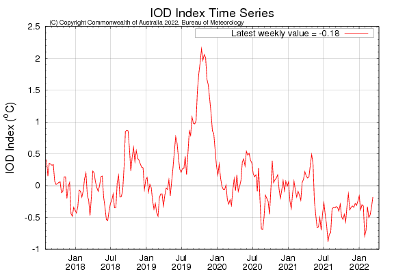
IOD: The Indian Ocean Dipole is currently neutral. The latest weekly value of the IOD index to 13 March was -0.18°C. There is a rise of 0.16°C as against its last week value of -0.34°C (06 march). It typically has little influence on global climate from December to April due to displacement of the monsoon trough.
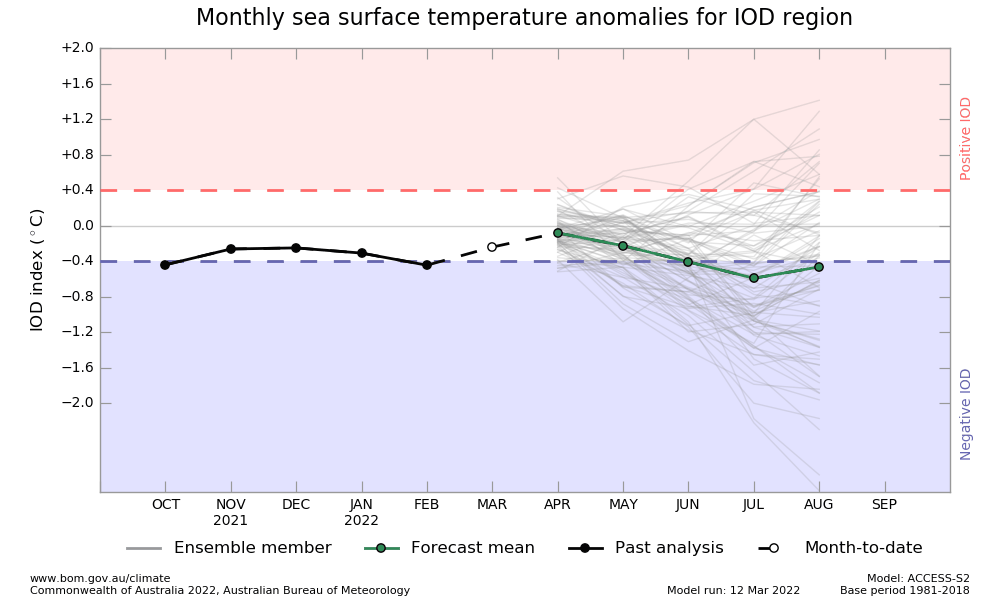
However, IOD projections continue to uphold its -ve amplitude albeit within the threshold limits of ‘neutral’.
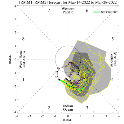
MJO: Both, dynamical and statistical Madden Julian Oscillation forecasts are in consonance. MJO is meandering over the Indian Ocean in phases 1 & 2 with moderate amplitude, placed outside the inner ring. This position remains favourable for enhancing cyclonic activity over the Bay of Bengal. It is likely to exit into the maritime continent during the last week of March. Subject to any pre-existing disturbance in the Indian Seas, MJO is in a position to escalate its impact.
Monsoon time is coming closer. Skymet will make a detailed forecast around mid-April. All the oceanic parameters play a very significant role in the overall performance of the season. El Nino/La Nina lead the table for a crucial role in assessing the likely conduct of monsoon.
