

ENSO is an irregular periodic variation in winds and sea surface temperature over the tropical eastern Pacific Ocean. This phenomenon has reach to affect climatic conditions over tropics and subtropics. The warming phase of the sea surface temperature is termed as El Nino and the cooling phase as La Nina. The ongoing La Nina conditions are expected to ease out and turn neutral by March 2023.

Oceanic Nino Index : The ONI, principal measure of El Nino / La Nina is reflected by the sea surface temperature in Nino 3.4 region. ONI is barely sustaining on the margins of cold neutral for the last 3 weeks. It is stuck at the threshold mark of - 0.5 degree since 06th Feb. It is expected to cross over to the neutral bounds anytime soon.

Equatorial sea surface temperatures are below average across most of the Pacific Ocean. The tropical Pacific atmosphere remains consistent with La Nina. Model based ENSO forecast of mid-Feb has bettered the chances of El Nino. El Nino and Neutral have equal share to start with in the quarter May-June-July and El Nino grows thereafter at the cost of Neutral. It contributes over 60% during the core monsoon months of July and August. Model forecasts at this time of the year are susceptible to error due to 'spring barrier'. Therefore, degree of confidence is low at this time and more authentic prediction emerge in April.

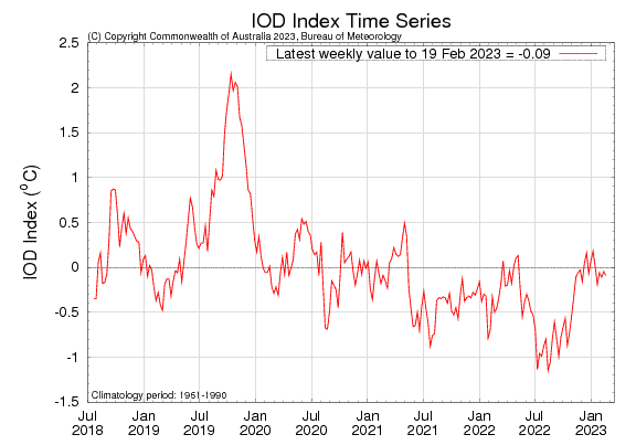
IOD : SST's are generally close to average across the tropical Indian Ocean. The Indian Ocean Dipole has remained neutral for the last 16 weeks. The IOD index value for the week ending 19th Feb 2023 was -0.09 deg. IOD is expected to turn +ve neutral shortly and thereafter stay within neutral bounds ( -0.4deg to +0.4deg) during pre monsoon season.
MJO : Madden Julian Oscillation has propagated eastward from the Maritime Continent across the Pacific. Courtesy La Nina conditions in the Pacific, MJO signal has turned weak. It is expected to gain amplitude and become active in the 1st week of March. An active MJO in the Pacific may weaken La Nina signal which as such is fading over the last few weeks. It may trigger formation of a cyclone off Australian coast in the north or northeast sector, in the initial days of March.

Gradual warming of the equatorial Pacific is the lead indicator of ensuing El Nino event. Negative sub-surface anomalies have also weakened over this area. Though, the model reliability is low at this point of time, the precursors are all hinting at an evolving El Nino during the monsoon months. The process may as well start, earlier than expected.
